NASA catches last image of Rafael as a hurricane, now merged with front
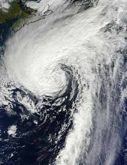
This visible image of Hurricane Rafael in the North Atlantic was taken from the MODIS instrument aboard NASA's Terra satellite on Oct. 17 at 1440 UTC (10:40 a.m. EDT). Rafael's northwestern fringe clouds were brushing Nova Scotia, Canada (top left).<br><br>Credit: NASA Goddard MODIS Rapid Response Team<br>
The Moderate Resolution Imaging Spectrometer (MODIS) instrument aboard NASA's Terra captured a visible image of Hurricane Rafael in the North Atlantic on Oct. 17 at 1440 UTC (10:40 a.m. EDT). Although Rafael was far from land, its northwestern fringe clouds were brushing Nova Scotia, Canada.
By 5 p.m. EDT on Oct. 17, Rafael had become extra-tropical, meaning that its core changed from a warm system to a cold system, just like a typical mid-latitude low pressure system. At that time, Rafael had maximum sustained winds near 75 mph (120 kph). It was centered near 40.2 North latitude and 56.5 West longitude, about 475 miles (750 km) southeast of Halifax, Nova Scotia, Canada. Rafael was moving to the northeast at 35 mph (56 kph). Turn toward the east-northeast with some increase in forward speed later today, Oct 18.
The National Hurricane Center noted that ocean swells generated by the cyclone are expected to affect the coast of eastern Canada during today and tomorrow. These swells are likely to cause life-threatening surf and rip currents.
By 5 p.m. EDT on Oct. 18, the cold front was found to be merged with the tropical cyclone, making it extra-tropical. Rafael is expected to complete a cyclonic loop around a deep-layer low over the north-central Atlantic day or two and ride into hurricane history.
Media Contact
More Information:
http://www.nasa.govAll latest news from the category: Earth Sciences
Earth Sciences (also referred to as Geosciences), which deals with basic issues surrounding our planet, plays a vital role in the area of energy and raw materials supply.
Earth Sciences comprises subjects such as geology, geography, geological informatics, paleontology, mineralogy, petrography, crystallography, geophysics, geodesy, glaciology, cartography, photogrammetry, meteorology and seismology, early-warning systems, earthquake research and polar research.


Newest articles

Properties of new materials for microchips
… can now be measured well. Reseachers of Delft University of Technology demonstrated measuring performance properties of ultrathin silicon membranes. Making ever smaller and more powerful chips requires new ultrathin…

Floating solar’s potential
… to support sustainable development by addressing climate, water, and energy goals holistically. A new study published this week in Nature Energy raises the potential for floating solar photovoltaics (FPV)…

Skyrmions move at record speeds
… a step towards the computing of the future. An international research team led by scientists from the CNRS1 has discovered that the magnetic nanobubbles2 known as skyrmions can be…

