NASA Casts Infrared Eye on Southern Indian Ocean's Tropical Cyclone Claudia
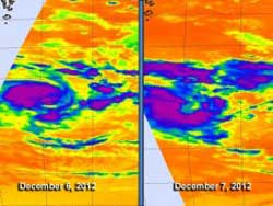
NASA's Aqua satellite flew over Tropical Cyclone Claudia on Dec. 6 at 2:59 p.m. EST/U.S. and Dec. 7 at 3:11 a.m. EST/U.S. The AIRS instrument showed the coldest, most powerful areas of the cyclone in purple, where cloud top temperatures exceeded – 63F/-52C.<br>Credit: NASA JPL, Ed Olsen <br>
Aqua flew over Tropical Cyclone Claudia on Dec. 6 at 1959 UTC (2:59 p.m. EST/U.S.) and Dec. 7 at 0811 UTC (3:11 a.m. EST/U.S.). The Atmospheric Infrared Sounder (AIRS) instrument analyzes storms in infrared light, and revealed the temperatures of clouds and sea surface around the storm. On Dec. 6, the coldest cloud top temperatures (colder than -63F/-52C) were located in the northwestern quadrant of the storm.
The next day, those strongest storms had shifted to the west and southwestern quadrants. The AIRS data on Dec. 7 also showed a much wider center of circulation, which was slightly exposed to outer winds. Thunderstorm development was also increasing around the center of circulation.
On Dec. 7 at 1500 UTC (10 a.m. EST), newly renamed Tropical Storm Claudia, formely Tropical Storm 03S had maximum sustained winds near 45 knots. Claudia was moving in a southerly direction and away from Diego Garcia. Claudia was centered near 14.3 south latitude and 75.4 east longitude, about 445 nautical miles south of Diego Garcia. Claudia is on a south-southwesterly track, but is expected to shift more to the south over the next several days.
Claudia is currently in an area of moderate (10 to 20 knots) vertical wind shear and sea surface temperatures warm enough to keep it going. AIRS data indicates that sea surface temperatures were near 28 to 29 degrees Celsius.
Over the weekend of Dec. 8 and 9, however, Claudia will venture into cooler waters and the vertical wind shear is forecast to increase. Those two factors indicate that Claudia will weaken and become an extra-tropical storm over the weekend.
Text Credit: Rob Gutro
NASA's Goddard Space Flight Center
Media Contact
All latest news from the category: Earth Sciences
Earth Sciences (also referred to as Geosciences), which deals with basic issues surrounding our planet, plays a vital role in the area of energy and raw materials supply.
Earth Sciences comprises subjects such as geology, geography, geological informatics, paleontology, mineralogy, petrography, crystallography, geophysics, geodesy, glaciology, cartography, photogrammetry, meteorology and seismology, early-warning systems, earthquake research and polar research.


Newest articles
Rocks with the oldest evidence yet of Earth’s magnetic field
The 3.7 billion-year-old rocks may extend the magnetic field’s age by 200 million years. Geologists at MIT and Oxford University have uncovered ancient rocks in Greenland that bear the oldest…

Decisive breakthrough for battery production
Storing and utilising energy with innovative sulphur-based cathodes. HU research team develops foundations for sustainable battery technology Electric vehicles and portable electronic devices such as laptops and mobile phones are…

Superradiant atoms could push the boundaries of how precisely time can be measured
Superradiant atoms can help us measure time more precisely than ever. In a new study, researchers from the University of Copenhagen present a new method for measuring the time interval,…

