NASA adds up Hurricane Sandy's rainfall from space
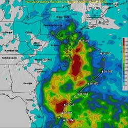
This TRMM rainfall analysis indicates that the heaviest rainfall totals of greater than 260mm (10.2 inches) were over the open waters of the Atlantic Ocean. Rainfall totals of over 180mm (~ 7 inches) are also shown over land in many areas near the Atlantic coast from New Jersey to South Carolina. Hurricane Sandy's track over the Atlantic Ocean is shown overlaid on this analysis in white.<br><br>Credit: SSAI/NASA, Hal Pierce<br>
Much of the recent deadly flooding along the northeastern United States coastlines was caused by super storm Sandy's storm swell. Strong winds from Sandy persistently pushed Atlantic Ocean waters toward the coast. High tides that occurred at the same time also magnified the effects of the storm swell. Some flooding was also caused by long periods of heavy rainfall that made rivers and streams overflow their banks.
The TRMM-based, near-real time Multi-satellite Precipitation Analysis (MPA) is done at NASA's Goddard Space Flight Center in Greenbelt, Md. The MPA monitors rainfall over a large area of the globe (from 60 degrees North latitude to 60 degrees South latitude). MPA rainfall totals over the eastern United States were calculated for the period from October 24-31, 2012 when super storm Sandy was making it's catastrophic transit through the area.
The rainfall analysis indicated that the heaviest rainfall totals of greater than 260mm (10.2 inches) were over the open waters of the Atlantic Ocean. Rainfall totals of over 180mm (~ 7 inches) occurred over land in many areas near the Atlantic coast from New Jersey to South Carolina.
The reported death toll from hurricane Sandy's flooding and high winds has now reached above 120. Over 70 deaths were caused by Sandy in the Caribbean and recent reports bring the total to greater than 50 in the United States.
NOAA's Hydrometeorological Prediction Center issued their last advisory on Sandy's remnants on Oct. 31, stating that “multiple centers of circulation in association with the remnants of Sandy can be found across the lower Great Lakes.”
A visible image from NOAA's GOES-13 satellite at 1:31 p.m. EDT on Nov. 1, 2012 showed the remnant clouds from Sandy still lingered over the Great Lakes and stretched east to New England and north into Canada.
The book on this super storm is now closed, though the clean-up will continue for a long time to come.
Media Contact
More Information:
http://www.nasa.govAll latest news from the category: Earth Sciences
Earth Sciences (also referred to as Geosciences), which deals with basic issues surrounding our planet, plays a vital role in the area of energy and raw materials supply.
Earth Sciences comprises subjects such as geology, geography, geological informatics, paleontology, mineralogy, petrography, crystallography, geophysics, geodesy, glaciology, cartography, photogrammetry, meteorology and seismology, early-warning systems, earthquake research and polar research.


Newest articles

Machine learning algorithm reveals long-theorized glass phase in crystal
Scientists have found evidence of an elusive, glassy phase of matter that emerges when a crystal’s perfect internal pattern is disrupted. X-ray technology and machine learning converge to shed light…

Mapping plant functional diversity from space
HKU ecologists revolutionize ecosystem monitoring with novel field-satellite integration. An international team of researchers, led by Professor Jin WU from the School of Biological Sciences at The University of Hong…

Inverters with constant full load capability
…enable an increase in the performance of electric drives. Overheating components significantly limit the performance of drivetrains in electric vehicles. Inverters in particular are subject to a high thermal load,…

