NASA gets a cold stare from Emilia's eye
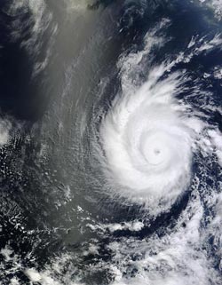
NASA's Terra satellite captured this visible image of Hurricane Emilia following Tropical Storm Daniel in the Eastern Pacific Ocean on July 9, 2012, at 1825 UTC / 2:25 p.m. EDT. Credit: NASA MODIS Rapid Response Team<br>
The Atmospheric Infrared Sounder (AIRS) instrument that flies onboard NASA's Aqua satellite measured cloud top temperatures in the powerful thunderstorms surrounding Emilia's eye to be colder than -94 Fahrenheit (-70 Celsius). That indicates that they're very high in the troposphere, and very powerful (which would coincide with Emilia being a major hurricane).
NASA's Terra satellite captured a visible image of Hurricane Emilia on July 9, 2012 at 1825 UTC / 2:25 p.m. EDT, and Emilia's eye was clearly visible in the image.
Emilia exploded from a Category 2 hurricane to a Category 4 hurricane on the Saffir-Simpson Scale since yesterday. Today, July 10 at 5 a.m. EDT, Emilia's maximum sustained winds were near 140 mph (220 kmh). By 11 a.m. EDT, Emilia's maximum sustained winds dropped to 130 mph (215 kmh),still holding to Category 4 hurricane status. Emilia was located about 685 miles (1100 km) south-southwest of the southern tip of Baja California. Emilia is moving at 10 mph (17 kmh) to the west-northwest.
The National Hurricane Center expects Emilia to continue weakening tonight through Thursday, July 12.
Behind Emilia to the east, lies System 98E, a tropical low pressure area that appears to be developing. The National Hurricane Center gives System 98E a 40 percent chance for development over the next couple of days. That means that while Emilia is chasing Tropical Storm Daniel (west of Emilia), there may be another named storm chasing Emilia in the next couple of days.
Media Contact
More Information:
http://www.nasa.govAll latest news from the category: Earth Sciences
Earth Sciences (also referred to as Geosciences), which deals with basic issues surrounding our planet, plays a vital role in the area of energy and raw materials supply.
Earth Sciences comprises subjects such as geology, geography, geological informatics, paleontology, mineralogy, petrography, crystallography, geophysics, geodesy, glaciology, cartography, photogrammetry, meteorology and seismology, early-warning systems, earthquake research and polar research.


Newest articles

Bringing bio-inspired robots to life
Nebraska researcher Eric Markvicka gets NSF CAREER Award to pursue manufacture of novel materials for soft robotics and stretchable electronics. Engineers are increasingly eager to develop robots that mimic the…

Bella moths use poison to attract mates
Scientists are closer to finding out how. Pyrrolizidine alkaloids are as bitter and toxic as they are hard to pronounce. They’re produced by several different types of plants and are…

AI tool creates ‘synthetic’ images of cells
…for enhanced microscopy analysis. Observing individual cells through microscopes can reveal a range of important cell biological phenomena that frequently play a role in human diseases, but the process of…

