NASA's TRMM satellite sees Melissa's tropical transition
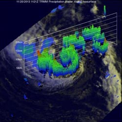
NASA's TRMM satellite saw Melissa on Nov. 20 after it became tropical. The tallest thunderstorms, over 8 miles high, were located northwest of the center.<br><br>Credit: SSAI/NASA, Hal Pierce<br>
NASA's Tropical Rainfall Measuring Mission or TRMM satellite passed directly above newly transformed Tropical Storm Melissa's center of circulation on November 20, 2013 at 11:21 UTC/6:21 a.m. EST. TRMM's Precipitation Radar (PR) instrument found that rain was falling at a maximum rate of 55 mm/~2.2 inches per hour in an area just to the southeast of Melissa's center of circulation.
TRMM Precipitation Radar data were also used to create a 3-D image that showed Melissa's structure. The TRMM data revealed that the tallest towers, reaching heights of over 13km/~8 miles, were located in a band of rainfall to the northwest of Melissa's center. The strongest intensity radar echo of over 49dBZ was returned from an area of heavy convective storms near Melissa's center. This heavy convection near the center signaled Melissa's transition from a subtropical storm to a tropical storm.
At 1500 UTC/10 a.m. EST, Melissa's maximum sustained winds were near 60 mph/95 kph. Melissa is a good sized storm, as tropical storm force winds extend outward up to 205 miles/335 km from the center.
The National Hurricane Center expects little change in strength over the next 24 hours, but does expect Melissa to lose her tropical characteristics thereafter, so her life as a tropical storm will be quite short.
Melissa's center was located near latitude 35.6 north and longitude 47.7 west, about 1,155 miles/1,860 km west of the Azores. The Azores is a group of nine volcanic islands in the North Atlantic Ocean. The island group is about 1,500 km/930 miles west of Lisbon, Portugal.
Melissa is moving toward the east-northeast near 30 mph/48 kph and this general motion is expected to continue during the next couple of days. The estimated minimum central pressure is 988 millibars.
Although Melissa is far from land, the storm is still generating large ocean swells, rip currents, and dangerous surf in Bermuda, parts of the Northern Leeward Islands, Puerto Rico and Hispaniola today.
The National Hurricane Center expects Melissa to continue moving northeast and pass north of the Azores.
Media Contact
More Information:
http://www.nasa.govAll latest news from the category: Earth Sciences
Earth Sciences (also referred to as Geosciences), which deals with basic issues surrounding our planet, plays a vital role in the area of energy and raw materials supply.
Earth Sciences comprises subjects such as geology, geography, geological informatics, paleontology, mineralogy, petrography, crystallography, geophysics, geodesy, glaciology, cartography, photogrammetry, meteorology and seismology, early-warning systems, earthquake research and polar research.


Newest articles

Bringing bio-inspired robots to life
Nebraska researcher Eric Markvicka gets NSF CAREER Award to pursue manufacture of novel materials for soft robotics and stretchable electronics. Engineers are increasingly eager to develop robots that mimic the…

Bella moths use poison to attract mates
Scientists are closer to finding out how. Pyrrolizidine alkaloids are as bitter and toxic as they are hard to pronounce. They’re produced by several different types of plants and are…

AI tool creates ‘synthetic’ images of cells
…for enhanced microscopy analysis. Observing individual cells through microscopes can reveal a range of important cell biological phenomena that frequently play a role in human diseases, but the process of…

