NASA's TRMM Satellite sees Andrea's heavy rains in Cuba, US East Coast
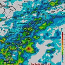
TRMM rainfall amounts (June 1-7) along Andrea's track (shown by the white line connecting the storm symbols) were between 45 and 90 mm (~2 to 4 inches, shown in darker blue and green, respectively; with locally high amounts from around 100 mm (~4 inches, shown in yellow) to around 150 mm (~6 inches, shown in red) over parts of South Carolina, eastern Georgia, and coastal North Carolina.<br><br>Credit: Credit: SSAI/NASA Goddard Space Flight Center, Hal Pierce<br>
This trough extended out over the Gulf from the Yucatan Peninsula and provided the focus for the development of showers and thunderstorms in the region, eventually leading to the formation of Tropical Storm Andrea.
With its suite of passive microwave and active radar sensors, the Tropical Rainfall Measuring Mission or TRMM satellite is ideally suited to measure rainfall from space. TRMM is a joint mission between NASA and the Japanese Space Agency.
For increased coverage, TRMM is used to calibrate rainfall estimates from other additional satellites. The TRMM- based, near-real time Multi-satellite Precipitation Analysis (TMPA) at the NASA Goddard Space Flight Center in Greenbelt, Maryland is used to estimate rainfall over a wide portion of the globe.
At NASA Goddard, the TMPA rainfall totals were calculated for the eastern Gulf and the surrounding region for the period 1-7 June 2013, covering the time before Andrea formed until it was passing through eastern North Carolina. The calculations were mapped on an image at NASA Goddard. The TRMM data showed rainfall totals on the order of 400 to 500 mm (~16 to 20 inches) stretching from the eastern tip of the Yucatan to western Cuba and over the southeast Gulf of Mexico. Upwards of 600 mm (~24 inches) occurred offshore over the Yucatan Straight. There were reports of widespread flooding over western Cuba but no injuries.
Elsewhere, amounts over South Florida are on the order of 100 to 200 mm (~4 to 8 inches), while amounts over northern Florida are generally on the order of 100 mm (~4 inches) or less.
As Andrea moved northward up the United States' east coast, it began to accelerate as it transitioned into an extra-tropical system. Because of this, rainfall amounts were significantly lighter. A second image created at NASA Goddard showed TMPA rainfall totals for the eastern U.S. for the same period (June 1 through 7). In general, rainfall amounts along Andrea's track were between 45 and 90 mm (~2 to 4 inches) with locally high amounts from around 100 mm (~4 inches to around 150 mm (~6 inches) over parts of South Carolina, eastern Georgia, and coastal North Carolina.
Text credit: Steve Lang
SSAI/NASA Goddard Space Flight Center
Media Contact
More Information:
http://www.nasa.govAll latest news from the category: Earth Sciences
Earth Sciences (also referred to as Geosciences), which deals with basic issues surrounding our planet, plays a vital role in the area of energy and raw materials supply.
Earth Sciences comprises subjects such as geology, geography, geological informatics, paleontology, mineralogy, petrography, crystallography, geophysics, geodesy, glaciology, cartography, photogrammetry, meteorology and seismology, early-warning systems, earthquake research and polar research.


Newest articles

“Nanostitches” enable lighter and tougher composite materials
In research that may lead to next-generation airplanes and spacecraft, MIT engineers used carbon nanotubes to prevent cracking in multilayered composites. To save on fuel and reduce aircraft emissions, engineers…

Trash to treasure
Researchers turn metal waste into catalyst for hydrogen. Scientists have found a way to transform metal waste into a highly efficient catalyst to make hydrogen from water, a discovery that…

Real-time detection of infectious disease viruses
… by searching for molecular fingerprinting. A research team consisting of Professor Kyoung-Duck Park and Taeyoung Moon and Huitae Joo, PhD candidates, from the Department of Physics at Pohang University…

