NASA's TRMM Satellite sees a small area of heavy rain left in Tropical Storm Hector
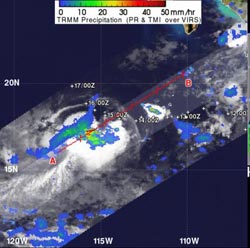
The TRMM satellite captured rainfall rates from Tropical Storm Hector on Aug. 14, 2012 1:28 a.m. EDT. TRMM data showed that Hector had a small area of moderate to heavy rainfall around the center of circulation. Heavy rainfall appears in red, falling at 2 inches/50 mm per hour. Light to moderate rainfall is depicted in blue and green (falling at a rate between .78 to 1.57 inches (20 to 40 mm) per hour.<br><br>Credit: Credit: SSAI/NASA, Hal Pierce<br>
The Tropical Rainfall Measuring Mission satellite known as TRMM is managed by both NASA and the Japanese Space Agency. From its orbit in space, TRMM's instruments can estimate rainfall from tropical cyclones.
The TRMM satellite captured rainfall rates from Tropical Storm Hector on August 14, 2012 1:28 a.m. EDT. TRMM data showed that Hector had a small area of moderate to heavy rainfall around the center of circulation. That small area of heavy rainfall was falling at 2 inches/50 mm per hour. For the most part, rainfall was light-to-moderate in other areas of Hector.
Hector is being battered by moderate winds from the east, and that has been pushing the rainfall to the west of the storm's center. That wind shear is expected to be around for the next couple of days, which will prevent Hector from strengthening.
On Tuesday, August 14 at 11 a.m. EDT (1500 UTC) Hector's maximum sustained winds remained near 45 mph (75 kmh). The center of Tropical Storm Hector was about 230 miles (365 km) west-southwest of Socorro Island and about 440 miles (710 km) southwest of the southern tip of Baja California. That puts Hector's center near latitude 18.1 north and longitude 114.4 west. Hector is moving toward the west near 6 mph (9 kmh).
Hector is moving west and is expected to turn northwest before weakening into a remnant low pressure area by the end of the week.
Media Contact
More Information:
http://www.nasa.govAll latest news from the category: Earth Sciences
Earth Sciences (also referred to as Geosciences), which deals with basic issues surrounding our planet, plays a vital role in the area of energy and raw materials supply.
Earth Sciences comprises subjects such as geology, geography, geological informatics, paleontology, mineralogy, petrography, crystallography, geophysics, geodesy, glaciology, cartography, photogrammetry, meteorology and seismology, early-warning systems, earthquake research and polar research.


Newest articles

Superradiant atoms could push the boundaries of how precisely time can be measured
Superradiant atoms can help us measure time more precisely than ever. In a new study, researchers from the University of Copenhagen present a new method for measuring the time interval,…

Ion thermoelectric conversion devices for near room temperature
The electrode sheet of the thermoelectric device consists of ionic hydrogel, which is sandwiched between the electrodes to form, and the Prussian blue on the electrode undergoes a redox reaction…

Zap Energy achieves 37-million-degree temperatures in a compact device
New publication reports record electron temperatures for a small-scale, sheared-flow-stabilized Z-pinch fusion device. In the nine decades since humans first produced fusion reactions, only a few fusion technologies have demonstrated…

