NASA'S TRMM Satellite provides rainfall estimate for Cyclone Phet
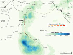
This TRMM satellite rainfall estimate map showed Cyclone Phet\'s heaviest rainfall (600 or more millimeters/23.6 or more inches) occurred over open waters of the Arabian Sea (blue) Northeast Oman received as much as 450 millimeters (17.7 inches), while Pakistan received between 150-300 millimeters/ 5.9-11.8 inches. The colored line indicates storm track and intensity. Credit: NASA /Jesse Allen<br>
TRMM satellite rainfall data estimated Cyclone Phet's heaviest rainfall (600 or more millimeters/23.6 or more inches) occurred over open waters of the Arabian Sea. One area of northeast Oman received as much as 450 millimeters (17.7 inches), while Pakistan received between 150-300 millimeters/ 5.9-11.8 inches as Phet made landfall there this past weekend.
NASA's Jesse Allen created a rainfall image is based on data from the Multi-satellite Precipitation Analysis (MPA) produced at NASA's Goddard Space Flight Center in Greenbelt, Md. The image showed both rainfall amounts and the storm track for Phet from May 31 to June 6, 2010. The MPS analysis estimates rainfall by combining measurements from many satellites and calibrating them using rainfall measurements from the Tropical Rainfall Measuring Mission (TRMM) satellite.
Tropical Cyclone Phet brought not just strong winds but also heavy rains to the Arabian Sea, the Arabian Peninsula, and the coast of Pakistan in late May and early June. Phet reached its greatest intensity off the coast of Oman on June 3. After making landfall in Oman, Phet dissipated somewhat, but remained organized enough to move back over the Arabian Sea toward Pakistan.
Media Contact
More Information:
http://www.nasa.govAll latest news from the category: Earth Sciences
Earth Sciences (also referred to as Geosciences), which deals with basic issues surrounding our planet, plays a vital role in the area of energy and raw materials supply.
Earth Sciences comprises subjects such as geology, geography, geological informatics, paleontology, mineralogy, petrography, crystallography, geophysics, geodesy, glaciology, cartography, photogrammetry, meteorology and seismology, early-warning systems, earthquake research and polar research.


Newest articles

Superradiant atoms could push the boundaries of how precisely time can be measured
Superradiant atoms can help us measure time more precisely than ever. In a new study, researchers from the University of Copenhagen present a new method for measuring the time interval,…

Ion thermoelectric conversion devices for near room temperature
The electrode sheet of the thermoelectric device consists of ionic hydrogel, which is sandwiched between the electrodes to form, and the Prussian blue on the electrode undergoes a redox reaction…

Zap Energy achieves 37-million-degree temperatures in a compact device
New publication reports record electron temperatures for a small-scale, sheared-flow-stabilized Z-pinch fusion device. In the nine decades since humans first produced fusion reactions, only a few fusion technologies have demonstrated…

