NASA's TRMM satellite measures drenching rains from Typhoon Sanba in Japan, South Korea
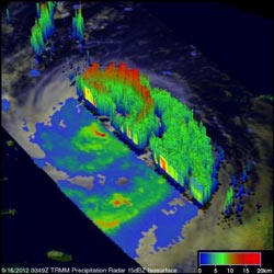
Powerful thunderstorms around Sanba's eye wall on Sept. 16, 2012, 0349 UTC were revealed to be about 12km (~7.5 miles) high. However, the tallest thunderstorm towers, reaching to 14km (~8.7 miles), were found by TRMM PR in an intense rain band shown circulating south of Sanba's center as it passed over Okinawa.<br><br>Credit: NASA/SSAI, Hal Pierce<br>
The Tropical Rainfall Measuring Mission (TRMM) satellite provided good coverage of Sanba as it passed over Typhoon Sanba on Sept. 16, 2012 at 0349 UTC, after Sanba had passed over Okinawa, Japan. Sanba was moving northward over the East China Sea toward South Korea and its circulation was affecting western Japan.
Later, the TRMM satellite again passed over Sanba on Sept. 16, 2012 at 2339 UTC (7:39 p.m. EDT). Data from TRMM's Microwave Imager (TMI) and Precipitation Radar (PR) instruments showed that Sanba was concentrating rain at a rate of over 90 mm (~3.5 inches) per hour in an area near South Korea's southern coast. TRMM saw that rain bands from Sanba were still producing scattered heavy showers as far away as the Japanese island of Shikoku.
TRMM Precipitation Radar (PR) data collected with the September 16, 2012 0349 UTC pass were used to create a 3-D cut-away view of the storm, looking from the northwest. At that time, the typhoon had weakened slightly but was still a strong category two typhoon with wind speeds of about 95 knots (~109 mph). The 3-D image showed powerful thunderstorms around Sanba's eye wall were about 12km (~7.5 miles) high. However, the tallest thunderstorm towers, reaching to 14km (~8.7 miles), were found by TRMM PR in an intense rain band shown circulating south of Sanba center.
On Sept. 17, Typhoon Sanba made landfall in the south Gyeongsang Province, located on the southern coast of South Korea.
Media Contact
More Information:
http://www.nasa.govAll latest news from the category: Earth Sciences
Earth Sciences (also referred to as Geosciences), which deals with basic issues surrounding our planet, plays a vital role in the area of energy and raw materials supply.
Earth Sciences comprises subjects such as geology, geography, geological informatics, paleontology, mineralogy, petrography, crystallography, geophysics, geodesy, glaciology, cartography, photogrammetry, meteorology and seismology, early-warning systems, earthquake research and polar research.


Newest articles

High-energy-density aqueous battery based on halogen multi-electron transfer
Traditional non-aqueous lithium-ion batteries have a high energy density, but their safety is compromised due to the flammable organic electrolytes they utilize. Aqueous batteries use water as the solvent for…

First-ever combined heart pump and pig kidney transplant
…gives new hope to patient with terminal illness. Surgeons at NYU Langone Health performed the first-ever combined mechanical heart pump and gene-edited pig kidney transplant surgery in a 54-year-old woman…

Biophysics: Testing how well biomarkers work
LMU researchers have developed a method to determine how reliably target proteins can be labeled using super-resolution fluorescence microscopy. Modern microscopy techniques make it possible to examine the inner workings…

