NASA's TRMM Satellite and HS3 Mission Checking out Tropical Storm Humberto
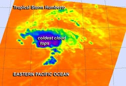
The AIRS instrument aboard NASA's Aqua satellite captured this infrared image of Humberto on Sept. 17 at 4:29 UTC/12:289 a.m. EDT. The image showed the highest storms and coldest cloud top temperatures (purple) northeast of the center.<br><br>Image Credit: NASA JPL, Ed Olsen<br>
NASA's Global Hawk 871 departed from NASA's Wallops Flight Facility, Wallops Island, Va. today, Sept. 17, at 10 a.m. EDT from Runway 04. This marked the twenty-fifth flight for NASA 871. Meanwhile, NASA 872 was returning to home base after making its seventy-fifth flight. These flights over Tropical Storm Humberto brought forth the one-hundredth flight of NASA's Global Hawks.
NASA's Global Hawk 872 unmanned aircraft took off at 10:42 a.m. EDT from Runway 22 at NASA's Wallops Flight Facility, Wallops Island, Va. on Sept. 16 to investigate Humberto and dispersed dropsondes throughout the storm. NASA 872 gathered data on the environment of the storm. Global Hawk aircraft are well-suited for hurricane investigations because they can fly for as long as 28 hours and over-fly hurricanes at altitudes greater than 60,000 feet (18.3 km).
Tropical storm Humberto had little deep convection and was classified by the National Hurricane Center (NHC) as a post-tropical cyclone on September 14, 2013. By September 16, Humberto was showing bursts of strong convection and thunderstorms were developing with heavy rainfall, so Humberto was again classified a tropical storm.
NASA's Tropical Rainfall Measuring Mission or TRMM satellite observed Humberto on September 15, 2013 at 1652 UTC (12:52 p.m. EDT) and on September 16, 2013 at 1557 UTC (11:57 a.m. EDT). A comparison of the two TRMM orbits showed significant changes that occurred within Humberto in less than 24 hours. In the first orbit on September 15, 2013 Humberto's center of circulation was rain free and only contained a small area of convective rainfall that was located well to the north of Humberto's surface location. Areas of strong convective rainfall were associated with rebounding Tropical Storm Humberto when TRMM viewed the same area on September 16, 2013.
The Atmospheric Infrared Sounder instrument aboard NASA's Aqua satellite captured an infrared image of Humberto on Sept. 17 at 4:29 UTC/12:289 a.m. EDT. The image showed the highest storms and coldest cloud top temperatures were still east and northeast of the center and were dropping the heaviest rainfall. .
At 11 a.m. EDT on Sept. 17 the center of Tropical Storm Humberto was located near latitude 29.4 north and longitude 42.5 west, about 1070 miles/1,720 km west-southwest of the Azores Islands. Humberto's maximum sustained winds were near 45 mph/75 kph and the National Hurricane Center expects some slight strengthening. Humberto is moving to the north at 10 mph/17 kph and is expected to turn to the northwest and slow down before heading north again on Sept. 18.
HS3 is a mission that brings together several NASA centers with federal and university partners to investigate the processes that underlie hurricane formation and intensity change in the Atlantic Ocean basin. Among those factors, HS3 will address the controversial role of the hot, dry and dusty Saharan Air Layer in tropical storm formation and intensification and the extent to which deep convection in the inner-core region of storms is a key driver of intensity change. The HS3 mission will operate between Aug. 20 and Sept. 23.
Humberto is forecast to again become a post-tropical low in about four days.
Text credit: Rob Gutro
NASA's Goddard Space Flight Center
Media Contact
All latest news from the category: Earth Sciences
Earth Sciences (also referred to as Geosciences), which deals with basic issues surrounding our planet, plays a vital role in the area of energy and raw materials supply.
Earth Sciences comprises subjects such as geology, geography, geological informatics, paleontology, mineralogy, petrography, crystallography, geophysics, geodesy, glaciology, cartography, photogrammetry, meteorology and seismology, early-warning systems, earthquake research and polar research.


Newest articles

Bringing bio-inspired robots to life
Nebraska researcher Eric Markvicka gets NSF CAREER Award to pursue manufacture of novel materials for soft robotics and stretchable electronics. Engineers are increasingly eager to develop robots that mimic the…

Bella moths use poison to attract mates
Scientists are closer to finding out how. Pyrrolizidine alkaloids are as bitter and toxic as they are hard to pronounce. They’re produced by several different types of plants and are…

AI tool creates ‘synthetic’ images of cells
…for enhanced microscopy analysis. Observing individual cells through microscopes can reveal a range of important cell biological phenomena that frequently play a role in human diseases, but the process of…

