NASA's TRMM satellite eyeing Tropical Storm Khanun's rainfall
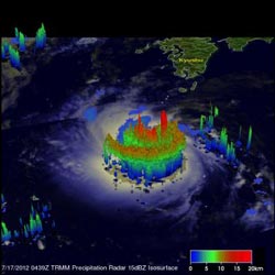
RMM's Precipitation Radar (PR) data were used to give a 3-D view of Khanun's rainfall structure of Khanun on July 17, 2012, at 0439 UTC. The 3-D view showed that powerful convective storms near Khanun's center were pushing to heights of about 17 km (~10.6 miles). Credit: Credit: SSAI/NASA, Hal Pierce<br>
The TRMM satellite had an excellent daytime look at Tropical Storm Khanun near Okinawa in the northwestern Pacific Ocean on July 17, 2012 at 0439 UTC (12:39 a.m. EDT/1:39 p.m. Japan). Khanun had estimated wind speeds of over 40 knots (~46 mph) at the time TRMM passed overhead.
The storm was compact but well organized and shows possible eye wall formation. The bulk of the strongest precipitation was occurring in the western semi-circle of the storm.
TRMM's Precipitation Radar (PR) data were used to give a 3-D view of Khanun's rainfall structure. The 3-D view showed that powerful convective storms near Khanun's center were pushing to heights of about 17 kilometers (~10.6 miles).
At 1500 UTC (11 a.m. EDT) on July 17, Khanun's maximum sustained winds had increased to 50 knots (57.5 mph/92.6 kmh). It was located about 95 nautical miles (109 miles/176 km) north-northeast of Kadena Air Base, Okinawa, Japan, near 27.8 North and 128.2 East. Khanun was moving to the northwest near 15 knots (17.2 mph/27.7 kmh). Tropical-storm-force winds extend out to 60 nautical miles (69 miles/111 km) from the center of circulation, so Kadena Air Base was not yet experiencing susatained tropical storm force winds at that time.
Khanun is predicted to slightly increase in power today. It is expected to affect both South and North Korea as it moves northward through the western side of the Yellow Sea over the next couple days.
Media Contact
More Information:
http://www.nasa.govAll latest news from the category: Earth Sciences
Earth Sciences (also referred to as Geosciences), which deals with basic issues surrounding our planet, plays a vital role in the area of energy and raw materials supply.
Earth Sciences comprises subjects such as geology, geography, geological informatics, paleontology, mineralogy, petrography, crystallography, geophysics, geodesy, glaciology, cartography, photogrammetry, meteorology and seismology, early-warning systems, earthquake research and polar research.


Newest articles

Superradiant atoms could push the boundaries of how precisely time can be measured
Superradiant atoms can help us measure time more precisely than ever. In a new study, researchers from the University of Copenhagen present a new method for measuring the time interval,…

Ion thermoelectric conversion devices for near room temperature
The electrode sheet of the thermoelectric device consists of ionic hydrogel, which is sandwiched between the electrodes to form, and the Prussian blue on the electrode undergoes a redox reaction…

Zap Energy achieves 37-million-degree temperatures in a compact device
New publication reports record electron temperatures for a small-scale, sheared-flow-stabilized Z-pinch fusion device. In the nine decades since humans first produced fusion reactions, only a few fusion technologies have demonstrated…

