NASA's Hurricane Mission explores Tropical Storm Nadine
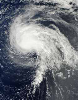
NASA's Terra satellite captured this true-color image of Hurricane Nadine in the Atlantic Ocean on Sept. 16 at 1345 UTC (9:45 a.m. EDT) while NASA's Global Hawk was flying around the storm.<br><br>Credit: NASA/Goddard/MODIS Rapid Response Team<br>
The Moderate Resolution Imaging Spectroradiometer aboard NASA's Terra satellite captured a true-color image of Hurricane Nadine in the Atlantic Ocean on Sept. 16 at 1345 UTC (9:45 a.m. EDT) while NASA's Global Hawk was flying around the storm.
Nadine strengthened to a hurricane on Friday, Sept. 14 at 11 p.m. EDT, and weakened back to a tropical storm on Sunday, Sept. 16 at 11 p.m. EDT. Nadine's highest wind speed as a hurricane was 80 mph (130 kmh).
NASA's Global Hawk landed back at the Wallops Flight Facility, Wallops Island, Va., in the morning hours on Sept. 15 after spending a full day gathering data from Hurricane Nadine.
“During the flight, Nadine strengthened from a tropical storm to a hurricane despite being hit by very strong westerly winds at upper levels and very dry air on its periphery,” said Scott Braun, HS3 Mission Principal Investigator from NASA's Goddard Space Flight Center, Greenbelt, Md. Data from this flight will help scientists determine how a storm like Nadine can intensify even in the presence of seemingly adverse conditions. Nadine is currently a tropical storm.
“The Global Hawk, one of two associated with the HS3 mission, sought to determine how the structure of Nadine might change under the influence of strong vertical wind shear as it moved northward in the Atlantic, ” Braun said. During its 22.5 hour flight around Nadine, the Global Hawk covered more than one million square kilometers (386,100 square miles) going back and forth over the storm in what's called a “lawnmower pattern.”
The Global Hawk captured data using instruments aboard and also dropping sensors called sondes into the storm. The dropsonde system ejected the small sensors tied to parachutes that drift down through the storm measuring winds, temperature and humidity.
At 11 a.m. EDT) on Sept. 17, Tropical Storm Nadine had maximum sustained winds near 70 mph (100 kmh). It was located about 585 miles southwest of the Azores, near 32.9 North and 35.3 East. Nadine is moving to the northeast near 15 mph (24 kmh). The National Hurricane Center forecasts some weakening in the next day.
Media Contact
More Information:
http://www.nasa.govAll latest news from the category: Earth Sciences
Earth Sciences (also referred to as Geosciences), which deals with basic issues surrounding our planet, plays a vital role in the area of energy and raw materials supply.
Earth Sciences comprises subjects such as geology, geography, geological informatics, paleontology, mineralogy, petrography, crystallography, geophysics, geodesy, glaciology, cartography, photogrammetry, meteorology and seismology, early-warning systems, earthquake research and polar research.


Newest articles

Superradiant atoms could push the boundaries of how precisely time can be measured
Superradiant atoms can help us measure time more precisely than ever. In a new study, researchers from the University of Copenhagen present a new method for measuring the time interval,…

Ion thermoelectric conversion devices for near room temperature
The electrode sheet of the thermoelectric device consists of ionic hydrogel, which is sandwiched between the electrodes to form, and the Prussian blue on the electrode undergoes a redox reaction…

Zap Energy achieves 37-million-degree temperatures in a compact device
New publication reports record electron temperatures for a small-scale, sheared-flow-stabilized Z-pinch fusion device. In the nine decades since humans first produced fusion reactions, only a few fusion technologies have demonstrated…

