NASA's Hot Tower Research Confirmed Again with Tropical Storm Sandy
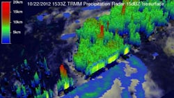
NASA's TRMM satellite flew over the developing tropical depression 18 on Oct. 21 at 8:40 p.m. EDT. This 3-D perspective showed powerful storms near the center were reaching altitudes of over 14 km (~8.7 miles). Red areas indicate heavy rainfall of 50 mm/2 inches per hour.<br>Credit: NASA/SSAI, Hal Pierce <br>
Sandy may further intensify into a hurricane and watches and warnings have been posted in the Caribbean Sea. On Oct. 23, a Hurricane Watch and Tropical Storm Warning were in effect for Jamaica, and a tropical storm watch was in effect for Haiti.
A low pressure center in the southwestern Caribbean sea was upgraded to Tropical Depression 18 by the National Hurricane Center (NHC) yesterday, Oct. 22 at 1500 UTC (11:00 a.m. EDT). The Tropical Rainfall Measuring Mission satellite, otherwise known as TRMM passed directly above the newly formed tropical depression on October 22, 2012 at 1533 UTC (October 21, 2012 at 11:33 p.m. EDT). TRMM's Microwave Imager (TMI) and Precipitation Radar (PR) data were used to determine the rainfall rates occurring within the depression and the newly formed tropical depression was already showing good organization. Some intense convective storms near the center of circulation dropping rain at a rate of about 50 mm (~2 inches) per hour.
NASA's 3-D Look at Tropical Storm Sandy
A 3-D perspective was made at NASA's Goddard Space Flight Center in Greenbelt, Md. using data from TRMM Precipitation Radar (PR) from the orbit. Powerful storms called “hot towers” located near the center of TD18's circulation were reaching altitudes of over 14 km (~8.7 miles). Towering thunderstorms like these at the center of tropical cyclones are often a sign of intensification.
A “hot tower” is a rain cloud that reaches at least to the top of the troposphere, the lowest layer of the atmosphere. The troposphere peaks around nine miles (14.5 km) high in the tropics. The towering clouds are called “hot” because they rise to such altitude due to the large amount of latent heat. Water vapor releases this latent heat as it condenses into liquid. NASA scientists Owen Kelley and John Stout of George Mason University and NASA's Goddard Space Flight Center, Greenbelt, Md., found that a tropical cyclone with a hot tower around its center of circulation was twice as likely to intensify within the next six hours, than a cyclone that lacked a tower. That's exactly what happened on Oct. 22, when TRMM spotted hot towers in Tropical Depression 18. It became Tropical Storm Sandy just six hours later.
Sandy's Stats on Oct. 23
On Oct. 23 at 8 a.m. EDT (1200 UTC), Tropical Storm Sandy's maximum sustained winds were near 45 mph (75 kph) and the National Hurricane Center expects the storm to strengthen over the next two days. The center of Tropical Storm Sandy was located near latitude 13.4 north and longitude 77.9 west, about 325 miles (525 km) south-southwest of Kingston, Jamaica. Sandy was moving to the north-northeast near 3 mph (6 kph) and is expected to continue in that direction for the next two days taking the center of the tropical storm near or over Jamaica on Wed. Oct. 24. Sandy's estimated minimum central pressure is 997 millibars.
NASA Infrared Data on Sandy
Infrared satellite imagery captured on Oct. 23 at 0617 UTC (2:17 a.m. EDT) from the Atmospheric Infrared Sounder instrument aboard NASA's Aqua satellite showed that there are bands of strong thunderstorms east of Sandy's center of circulation . Those bands of thunderstorms are reaching high into the troposphere where cloud top temperatures are as cold as -63 Fahrenheit (-52 Celsius).
Sandy's Wind, Rain, Storm Surge
Tropical storm winds are expected to reach Jamaica during the night-time hours of Oct. 23 or early morning hours on Wed. Oct. 24. The National Hurricane Center noted that “hurricane conditions expected on Wed. Hurricane conditions are also possible in eastern Cuba by Wed. night. Tropical storm conditions are possible in Haiti on Oct. 24, and in central and southeastern Bahamas on Thurs. Oct. 24.
Sandy is expected to be a big rainmaker, generating between six and 12 inches across Jamaica, Haiti , the Domenican Republic and eastern Cuba. Isolated rainfall totals could reach 20 inches. In addition, storm surges are expect to raise water levels between one and three feet above normal tide levels.
The National Hurricane Center expects Sandy to strengthen into a hurricane over the next couple of days.
Text credit: Rob Gutro
NASA's Goddard Space Flight Center, Greenbelt, Md.
Media Contact
All latest news from the category: Earth Sciences
Earth Sciences (also referred to as Geosciences), which deals with basic issues surrounding our planet, plays a vital role in the area of energy and raw materials supply.
Earth Sciences comprises subjects such as geology, geography, geological informatics, paleontology, mineralogy, petrography, crystallography, geophysics, geodesy, glaciology, cartography, photogrammetry, meteorology and seismology, early-warning systems, earthquake research and polar research.


Newest articles

How 3D printers can give robots a soft touch
Soft skin coverings and touch sensors have emerged as a promising feature for robots that are both safer and more intuitive for human interaction, but they are expensive and difficult…

Oxygen vacancies mediated ultrathin Bi4O5Br2 nanosheets
… as efficient piezocatalyst for synthesis of H2O2 from pure water. As an important chemical raw material, hydrogen peroxide (H2O2) is widely applied in various aspects of industry and life….

Atom-by-atom: Imaging structural transformations in 2D materials
Silicon-based electronics are approaching their physical limitations and new materials are needed to keep up with current technological demands. Two-dimensional (2D) materials have a rich array of properties, including superconductivity…

