NASA's Aura satellite measures pollution 'butterfly' from fires in central Africa
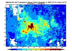
This image from the OMI instrument on NASA's Aura satellite shows nitrogen dioxide levels from July 7 through 12, 2011 in central Africa pertaining to agricultural fires. The highest levels of NO2 appear as a dark red butterfly over the southern Democratic Republic of the Congo. The NO2 is measured by the number of molecules in a cubic centimeter. Credit: NASA/James Acker<br>
An image of the pollution from agricultural fires in central Africa was created from data of nitrogen dioxide (NO2) levels over the period from July 7 to 12, 2011. It was created from Ozone Measuring Instrument (OMI) data using the NASA Giovanni system by Dr. James Acker at NASA's Goddard Space Flight Center in Greenbelt, Md.
Each year, people in the region burn croplands to clear fields after harvests. Burning is also used to create new growth in pastures and move grazing animals to new locations.
NO2 forms during fires when nitrogen reacts with oxygen. In fact, NO2 is formed in any combustion process where the oxygen is provided by Earth's atmosphere.
Detection of NO2 is important because it reacts with sunlight to create low-level ozone or smog and poor air quality. The OMI instrument that flies aboard NASA's Aura satellite is able to detect NO2. Low-level ozone (smog) is hazardous to the health of both plants and animals, and ozone in association with particulate matter causes respiratory problems in humans.
OMI measures NO2 by the number of molecules in a cubic centimeter. The highest concentrations appear in dark red and are coming from extreme northern Angola and south central part of the Democratic Republic of the Congo. The high concentration coming from the DRC appears to look like a butterfly.
OMI data is archived at the NASA Goddard Earth Sciences Data and Information Services Center (GES DISC), and is provided by KNMI, the Koninklijk Nederlands Meteorologisch Instituut (Royal Netherlands Meteorological Institute). Dr. P.F. Levelt is the Principal Investigator of OMI, Dr. J. Tamminen is the Finnish Co-PI, and Dr. P.K. Bhartia leads the U.S. OMI science team. Dr. James Gleason (NASA) and Pepijn Veefkind (KNMI) are PIs of the OMI NO2 product.
Media Contact
More Information:
http://www.nasa.govAll latest news from the category: Earth Sciences
Earth Sciences (also referred to as Geosciences), which deals with basic issues surrounding our planet, plays a vital role in the area of energy and raw materials supply.
Earth Sciences comprises subjects such as geology, geography, geological informatics, paleontology, mineralogy, petrography, crystallography, geophysics, geodesy, glaciology, cartography, photogrammetry, meteorology and seismology, early-warning systems, earthquake research and polar research.


Newest articles

Superradiant atoms could push the boundaries of how precisely time can be measured
Superradiant atoms can help us measure time more precisely than ever. In a new study, researchers from the University of Copenhagen present a new method for measuring the time interval,…

Ion thermoelectric conversion devices for near room temperature
The electrode sheet of the thermoelectric device consists of ionic hydrogel, which is sandwiched between the electrodes to form, and the Prussian blue on the electrode undergoes a redox reaction…

Zap Energy achieves 37-million-degree temperatures in a compact device
New publication reports record electron temperatures for a small-scale, sheared-flow-stabilized Z-pinch fusion device. In the nine decades since humans first produced fusion reactions, only a few fusion technologies have demonstrated…

