NASA's Aqua satellite sees weaker Tropical Depression Errol crossing West Timor
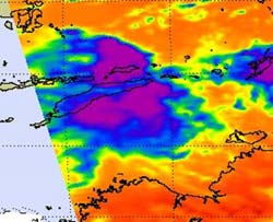
AIRS instrument aboard NASA's Aqua satellite captured an infrared image on April 18 at 04:53 UTC (12:53 a.m. EDT) that showed very little strong (purple) convection remained in Errol and most cloud tops were warming (blue). Credit: NASA/JPL, Ed Olsen<br>
West Timor is the western and Indonesian portion of the island of Timor. To the east lies the Timor Sea, to the west is the Southern Indian Ocean.
The Atmospheric Infrared Sounder (AIRS) instrument aboard NASA's Aqua satellite captured an infrared image on April 18 at 04:53 UTC (12:53 a.m. EDT) that showed very little strong convection (rapidly rising air that forms thunderstorms) remained in Errol. The strongest areas of convection had cloud-top temperatures as cold as -63F/-52C. However, AIRS data shows that much of the cloud top temperatures in the depression have since warmed.
Cloud-top temperatures are important because they tell forecasters how high thunderstorms are, and the higher the thunderstorm, the colder the cloud tops and the more powerful the thunderstorms. Warming cloud top temperatures mean lower cloud heights and indicate that the storm is growing weaker. It means that there's not as much power to lift the air up to create the thunderstorms that power it.
As usually happens when a tropical cyclone crosses land, it weakens because it is cut-off from the warm ocean waters that power it. In addition, vertical wind shear has increased to 15 knots (17 mph/28 kmh) providing additional weakening.
Tropical Depression Errol had maximum sustained winds near 30 knots (34 mph/55 kmh) on Monday, April 18 at 1200 UTC (8 a.m. EDT). It was located about 35 nautical miles west-northwest of Kupang, West Timor near 10.0 South and 122.9 East. It was moving northwestward at 1 knot (1 mph/2 kmh). By 12 p.m. EDT on April 18, Kupang, West Timor, Indonesia was reporting cloudy skies and rising pressure, indicating that Tropical Depression Errol was moving away.
Errol is encountering wind shear and is expected to continue weakening as it moves west to west-southwest. The Joint Typhoon Warning Center forecasters note that in addition to being weakened from tracking over land, and encountering increased wind shear, drier air is moving in, which will sap the moisture and ability to generate thunderstorms within. Errol is forecast to dissipate in the open waters of the Southern Indian Ocean in a day or two.
Media Contact
More Information:
http://www.nasa.govAll latest news from the category: Earth Sciences
Earth Sciences (also referred to as Geosciences), which deals with basic issues surrounding our planet, plays a vital role in the area of energy and raw materials supply.
Earth Sciences comprises subjects such as geology, geography, geological informatics, paleontology, mineralogy, petrography, crystallography, geophysics, geodesy, glaciology, cartography, photogrammetry, meteorology and seismology, early-warning systems, earthquake research and polar research.


Newest articles

Bringing bio-inspired robots to life
Nebraska researcher Eric Markvicka gets NSF CAREER Award to pursue manufacture of novel materials for soft robotics and stretchable electronics. Engineers are increasingly eager to develop robots that mimic the…

Bella moths use poison to attract mates
Scientists are closer to finding out how. Pyrrolizidine alkaloids are as bitter and toxic as they are hard to pronounce. They’re produced by several different types of plants and are…

AI tool creates ‘synthetic’ images of cells
…for enhanced microscopy analysis. Observing individual cells through microscopes can reveal a range of important cell biological phenomena that frequently play a role in human diseases, but the process of…

