Living at the edge of an active volcano: Risk from lava flows on Mount Etna
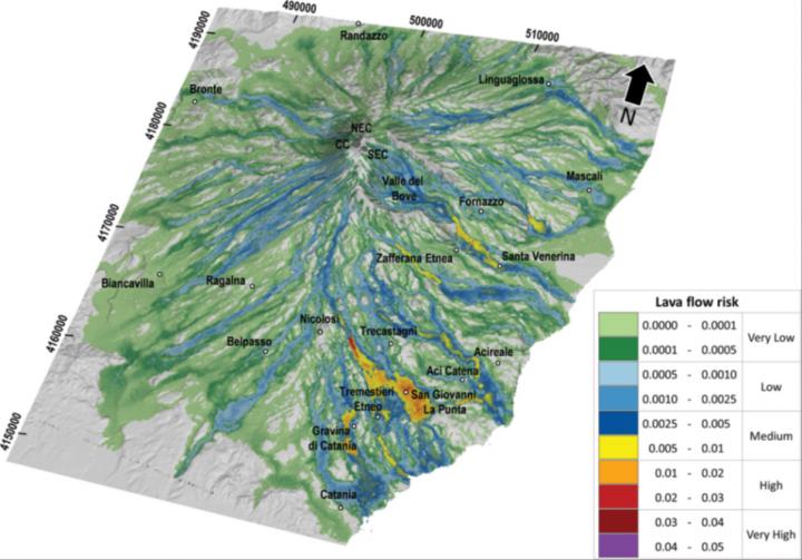
Oblique view of the risk map for lava flow inundation on the flanks of Mt. Etna for the next 50 years. Colors represent different levels of risk and indicate the probability of damage. The lava flow risk map constitutes a powerful instrument to promptly evaluate the real cost of living in areas near Mt. Etna and provide a tool both for the management of the eruptive emergencies and the long-term planning of the territory. In addition, the risk assessment approach developed by researchers of the TecnoLab at the INGV in Catania allows a fast update of the risk map including new data as soon as they are available. Credit: Ciro del Negro and colleagues.
On Mt. Etna volcano, inhabited areas have been inundated repeatedly by lava flows in historical times. The increasing exposure of a larger population, which has almost tripled in the area around Mt. Etna during the last 150 years, has resulted from on a poor assessment of the volcanic hazard and risk, allowing inappropriate land use in vulnerable areas.
Thus, the researchers of the Laboratory of Technologies for Volcanology (TecnoLab) at the INGV in Catania assessed and mapped hazard, exposure, and risk for providing a basic broad overview of the potential effusive eruption impacts on the flanks of Mt. Etna.
Despite our knowledge of volcanic hazards and our capability to monitor volcanic activity, the possibility that effusive eruptions of Etna volcano could harm people, properties and services is greater today than ever before. A 2013 analysis of lava flow hazards and their distribution around the Etna volcano showed them to be far more dangerous than previously expected.
There is no compelling evidence to think that rates and magnitudes of volcanism are changing, but, as a consequence of rising population densities, increasingly sophisticated facilities, and expanding complex social and economic infrastructure, all communities around Mt. Etna are becoming more vulnerable to experiencing heavy consequences from volcanic hazard activity.
The researchers of the TecnoLab assessed the lava flow risk on the flanks of Mt. Etna by using a GIS-based approach that combines simply the hazard with the exposure of elements at stake (the vulnerability was not considered).
The hazard, showing the long-term probability related to lava flow inundation, was obtained by combining three different kinds of information: the spatiotemporal probability of the future opening of new flank eruptive vents, the event probability associated with classes of expected eruptions, and the overlapping of lava flow paths simulated by the MAGFLOW model.
Data including all exposed elements were gathered from institutional web portals and high-resolution satellite imagery, and organized in four thematic layers: population, buildings, service networks, and land use. The total exposure is given by a weighted linear combination of the four thematic layers, where weights are calculated using the Analytic Hierarchy Process (AHP).
The resulting risk map shows the likely damage caused by a lava flow eruption, allowing rapid visualization of the areas in which there would be the greatest losses if a flank eruption occurred on Mt. Etna. The highest hazard levels were obtained within the uninhabited Valle del Bove and along the upper portions of the South and North-East Rifts.
Instead, higher exposure levels were found near the eastern coast where the population is highly concentrated and, as a consequence, there are wider urban areas and critical infrastructures. By combining the location of the main population centers on Etna with those where the hazard is high, we identified the south-eastern flank as the sector with the highest overall level of risk due to effusive eruptions from vents located on the volcano flanks.
###
FEATURED ARTICLE
Living at the edge of an active volcano: Risk from lava flows on Mt. Etna
Ciro del Negro and colleagues, https:/
GSA BULLETIN articles published ahead of print are online at http://bulletin.
Media Contact
More Information:
https://www.geosociety.org/GSA/News/pr/2019/19-45.aspxAll latest news from the category: Earth Sciences
Earth Sciences (also referred to as Geosciences), which deals with basic issues surrounding our planet, plays a vital role in the area of energy and raw materials supply.
Earth Sciences comprises subjects such as geology, geography, geological informatics, paleontology, mineralogy, petrography, crystallography, geophysics, geodesy, glaciology, cartography, photogrammetry, meteorology and seismology, early-warning systems, earthquake research and polar research.


Newest articles

Optimising inventory management
Crateflow enables accurate AI-based demand forecasts. A key challenge for companies is to control overstock and understock while developing a supply chain that is resilient to disruptions. To address this,…

Cause of rare congenital lung malformations
Gene mutations in the RAS-MAPK signaling pathway disrupt lung development in the womb. Most rare diseases are congenital – including CPAM (congenital pulmonary airway malformations). These are airway malformations of…

“Nanostitches” enable lighter and tougher composite materials
In research that may lead to next-generation airplanes and spacecraft, MIT engineers used carbon nanotubes to prevent cracking in multilayered composites. To save on fuel and reduce aircraft emissions, engineers…

