Landsat Satellites Track Continued Missouri River Flooding
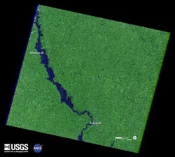
Flooding down the Missouri River continues along the Nebraska and Iowa border as shown in this Landsat 7 satellite image of July 17, 2011. Heavy rains and snowmelt have caused record flows. Green represents vegetation, dark blue is water. Credit: USGS/NASA <br>
A Landsat 5 image of the area from May 5, 2011 shows normal flow. In contrast, a Landsat 7 image from July 17 depicts flood conditions in the same location.
A national overview map of streamflow provided by U.S. Geological Survey (USGS) WaterWatch graphically portrays the immense geographic extent of flooding in the Missouri River basin.
Monitoring both floods and droughts, the USGS WaterWatch internet site displays maps, graphs, and tables that describe current and past streamflow conditions for the United States. The real-time streamflow data is generally updated on an hourly basis.
The Landsat Program is a series of Earth-observing satellite missions jointly managed by NASA and the U.S. Geological Survey. Landsat satellites have been consistently gathering data about our planet since 1972. They continue to improve and expand this unparalleled record of Earth’s changing landscapes, for the benefit of all. The next Landsat satellite is scheduled to launch in December 2012.
For the USGS WaterWatch website, please visit:
http://waterwatch.usgs.gov/new/index.php?id=ww
For more information about the Landsat launching in 2012: http://ldcm.gsfc.nasa.gov Jon Campbell, USGS,703-648-4180 joncampbell@usgs.gov
Rob Gutro, NASA's Goddard Space Flight Center, Robert.j.gutro@Nasa.gov
Media Contact
All latest news from the category: Earth Sciences
Earth Sciences (also referred to as Geosciences), which deals with basic issues surrounding our planet, plays a vital role in the area of energy and raw materials supply.
Earth Sciences comprises subjects such as geology, geography, geological informatics, paleontology, mineralogy, petrography, crystallography, geophysics, geodesy, glaciology, cartography, photogrammetry, meteorology and seismology, early-warning systems, earthquake research and polar research.


Newest articles

Superradiant atoms could push the boundaries of how precisely time can be measured
Superradiant atoms can help us measure time more precisely than ever. In a new study, researchers from the University of Copenhagen present a new method for measuring the time interval,…

Ion thermoelectric conversion devices for near room temperature
The electrode sheet of the thermoelectric device consists of ionic hydrogel, which is sandwiched between the electrodes to form, and the Prussian blue on the electrode undergoes a redox reaction…

Zap Energy achieves 37-million-degree temperatures in a compact device
New publication reports record electron temperatures for a small-scale, sheared-flow-stabilized Z-pinch fusion device. In the nine decades since humans first produced fusion reactions, only a few fusion technologies have demonstrated…

