Landsat 5 satellite sees Mississippi River floodwaters lingering
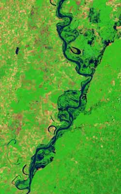
The Landsat 5 satellite Thematic Mapper captured this images on June 11, 2011. In this false-color images, water is navy blue. Depending on land use, land above water is green or burnt orange. The image is rotated, with the left sides facing north. Credit: Credit: NASA Earth Observatory images created by Jesse Allen and Robert Simmon, using Landsat data provided by the United States Geological Survey<br>
On May 19, 2011, the Mississippi River reached a historic crest at Vicksburg. According to the Advanced Hydrological Prediction Service (AHPS) of the U.S. National Weather Service, the river reached 57.10 feet (17.40 meters) that day. By early June, flooding had receded considerably around Vicksburg, but water remained high.
On June 14, the AHPS reported that the Mississippi River reached 44.88 feet (13.68 meters) at Vicksburg. At that point, the river was in minor flood stage, and its level was forecast to continue falling through June 19.
The Landsat series of satellites is used by emergency managers to acquire a range of imagery, from floods to fires. Landsat has recently provided both images of the flooding of the Mississippi River and the fires raging in Arizona.
The Landsat Program is a series of Earth-observing satellite missions jointly managed by NASA and the U.S. Geological Survey. Landsat satellites have been consistently gathering data about our planet since 1972. They continue to improve and expand this unparalleled record of Earth's changing landscapes, for the benefit of all. The next Landsat satellite is scheduled to launch in December 2012.
Media Contact
More Information:
http://www.nasa.govAll latest news from the category: Earth Sciences
Earth Sciences (also referred to as Geosciences), which deals with basic issues surrounding our planet, plays a vital role in the area of energy and raw materials supply.
Earth Sciences comprises subjects such as geology, geography, geological informatics, paleontology, mineralogy, petrography, crystallography, geophysics, geodesy, glaciology, cartography, photogrammetry, meteorology and seismology, early-warning systems, earthquake research and polar research.


Newest articles

Properties of new materials for microchips
… can now be measured well. Reseachers of Delft University of Technology demonstrated measuring performance properties of ultrathin silicon membranes. Making ever smaller and more powerful chips requires new ultrathin…

Floating solar’s potential
… to support sustainable development by addressing climate, water, and energy goals holistically. A new study published this week in Nature Energy raises the potential for floating solar photovoltaics (FPV)…

Skyrmions move at record speeds
… a step towards the computing of the future. An international research team led by scientists from the CNRS1 has discovered that the magnetic nanobubbles2 known as skyrmions can be…

