Infrared NASA Satellite Imagery Confirmed Newborn Tropical Storm Sonca
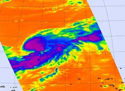
This infrared image of Tropical Storm Sonca was captured on Sept. 14 at 10:41 p.m. EDT. The purple area around the center of circulation indicates the coldest, highest cloud heights, where the heaviest rain was occurring. Satellite data also shows Sonca has taken on the signature "comma" shape of a tropical storm. Credit: NASA JPL, Ed Olsen<br>
Infrared imagery is gathered by the Atmospheric Infrared Sounder (AIRS) instrument that flies on NASA's Aqua satellite. It provides valuable information to forecast organizations such as the Joint Typhoon Warning Center and National Hurricane Center about cloud temperatures and heights and sea-surface temperatures.
Infrared data provides valuable clues about how a tropical cyclone is going to behave. High, cold clouds with temperatures colder than -63 Fahrenheit (-52 Celsius) within a tropical cyclone tell meteorologists that convection (rising air that forms thunderstorms that power a tropical cyclone) is strong, and further strengthening of the entire tropical cyclone is likely. When NASA satellites show that cloud temperatures are warming, it means there is less strength or uplift in the air to help form powerful thunderstorms.
When NASA's Aqua satellite flew over Tropical Storm Sonca on Sept. 14 at 10:41 p.m. EDT the AIRS instrument gathered that infrared temperature data about the thunderstorms that make up the storm. AIRS showed a large area around the center of circulation where the coldest, highest cloud heights, where the heaviest rain was occurring. Satellite data also showed Sonca has taken on the signature “comma” shape of a tropical storm.
Tropical Storm Sonca's maximum sustained winds are near 35 knots (40 mph) so it's just over the threshold of being a tropical storm. The storm is over 120 miles in diameter with tropical storm-force wind gusts out 60 miles from the center. Sonca is approximately 760 nautical miles east of the island of Iwo To, Japan and has tracked north-northwestward at 9 knots (10 mph).
Forecasters at the Joint Typhoon Warning Center are monitoring the progress of Sonca and using the infrared data that AIRS provides in addition data from other NASA satellites. Sonca is currently forecast to pass to the northeast of Chichi Jima, Japan over the weekend and bring gusty winds, heavy surf and rainfall to the island.
Text credit: Rob Gutro, NASA's Goddard Space Flight Center, Greenbelt, Md.
Media Contact
More Information:
http://www.nasa.govAll latest news from the category: Earth Sciences
Earth Sciences (also referred to as Geosciences), which deals with basic issues surrounding our planet, plays a vital role in the area of energy and raw materials supply.
Earth Sciences comprises subjects such as geology, geography, geological informatics, paleontology, mineralogy, petrography, crystallography, geophysics, geodesy, glaciology, cartography, photogrammetry, meteorology and seismology, early-warning systems, earthquake research and polar research.


Newest articles

Skyrmions move at record speeds
… a step towards the computing of the future. An international research team led by scientists from the CNRS1 has discovered that the magnetic nanobubbles2 known as skyrmions can be…
A flexible and efficient DC power converter for sustainable-energy microgrids
A new DC-DC power converter is superior to previous designs and paves the way for more efficient, reliable and sustainable energy storage and conversion solutions. The Kobe University development can…
Technical Trials for Easing the (Cosmological) Tension
A new study sorts through models attempting to solve one of the major challenges of contemporary cosmic science, the measurement of its expansion. Thanks to the dizzying growth of cosmic…

