Infrared NASA Data Shows Cyclone Haruna Being Blown Away
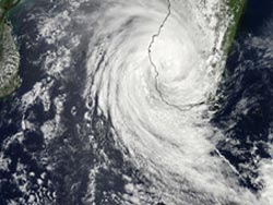
The MODIS instrument aboard NASA's Aqua satellite captured this visible image of Tropical Storm Haruna on Feb. 22 at 1105 UTC (6:05 a.m. EST). Credit: NASA Goddard MODIS Rapid Response Team<br>
Wind shear has been a problem for Haruna for days. A night-time image from the VIIRS instrument aboard NASA-NOAA's Suomi NPP satellite taken on Feb. 21 at 22:23 UTC showed the eye of Cyclone Haruna had elongated from northwest to southeast as a result of wind shear. For more information about the Suomi NPP satellite, visit: www.nasa.gov/npp.
On Sunday, Feb. 24, Haruna was centered near 27.2 south and 54.1 east, about 370 nautical miles (425.8 miles/682.5 km) south-southwest of La Reunion Island. Haruna's maximum sustained winds were near 40 knots (46 mph/74 kph) and the storm was moving to the east-southeast at 16 knots (18.4 mph/29.6 kph). An infrared image of Haruna captured by the Moderate Resolution Imaging Spectroradiometer instrument aboard NASA's Terra satellite showed the bulk of the clouds and rainfall were pushed south of the center. The storm was being battered by wind shear and that was pushing the main precipitation away from the center and elongating the storm.
On Feb. 24 at 2141 (4:41 p.m. EST), an infrared image from the Atmospheric Infrared Sounder (AIRS) instrument aboard NASA's Aqua satellite showed former Cyclone Haruna blowing apart several hundred miles south of La Reunion Island. AIRS showed that cloud top temperatures had warmed, indicating that cloud heights had dropped and the storm no longer had the strength in uplift that it previously had. For more information about AIRS, visit: http://airs.jpl.nasa.gov/.
The Joint Typhoon Warning Center issued their final advisory on the cyclone on Feb. 24. By Feb. 25 at 0000 UTC (7 p.m. EST/U.S. on Feb. 24) Tropical Cyclone Haruna had maximum sustained winds near 35 knots (40.2 mph/64.8 kph). It was centered near 27.0 south latitude and 57.5 east longitude, about 360 nautical miles south-southwest of La Reunion Island and was moving to the east-northeast at 15 knots (17.2 mph/27.7 kph). Haruna is being battered by wind shear and is expected to dissipate over the next couple of days.
Text Credit: Rob Gutro
NASA's Goddard Space Flight Center, Greenbelt, Md.
Media Contact
All latest news from the category: Earth Sciences
Earth Sciences (also referred to as Geosciences), which deals with basic issues surrounding our planet, plays a vital role in the area of energy and raw materials supply.
Earth Sciences comprises subjects such as geology, geography, geological informatics, paleontology, mineralogy, petrography, crystallography, geophysics, geodesy, glaciology, cartography, photogrammetry, meteorology and seismology, early-warning systems, earthquake research and polar research.


Newest articles

“Nanostitches” enable lighter and tougher composite materials
In research that may lead to next-generation airplanes and spacecraft, MIT engineers used carbon nanotubes to prevent cracking in multilayered composites. To save on fuel and reduce aircraft emissions, engineers…

Trash to treasure
Researchers turn metal waste into catalyst for hydrogen. Scientists have found a way to transform metal waste into a highly efficient catalyst to make hydrogen from water, a discovery that…

Real-time detection of infectious disease viruses
… by searching for molecular fingerprinting. A research team consisting of Professor Kyoung-Duck Park and Taeyoung Moon and Huitae Joo, PhD candidates, from the Department of Physics at Pohang University…

