Igor now a Category 4 hurricane with icy cloud tops and heavy rainfall
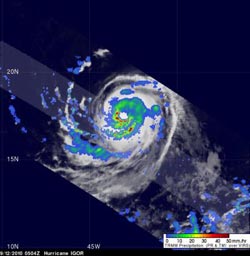
TRMM on Sept. 12 at 0504 UTC (1:04 a.m. EDT) captured an image of Hurricane Igor\'s rainfall, and there was a lot of heavy rain falling (red) at over 2 inches per hour.<br><br>Credit: NASA/SSAI, Hal Pierce<br>
Last week, Igor was a tropical storm who faded into a tropical depression. The National Hurricane Center had forecast that over the weekend Igor would approach more favorable conditions (low wind shear and warm sea surface temperatures) causing it to strengthen into a hurricane and it did. Tropical storm Igor was upgraded by the National Hurricane Center (NHC) in Miami, Florida to a hurricane on Sunday, September 12 at 0300 UTC (Sept. 11 at 11 p.m. EDT) .
The Tropical Rainfall Measuring Mission (TRMM) satellite, which is operated jointly by NASA and the Japanese Space Agency, JAXA captured a good look at Igor a few hours after it reached hurricane status. TRMM passed over Igor and captured his rainfall rates at 0504UTC ( 1:04 a.m. EDT). The TRMM Precipitation Radar (PR) and TRMM Microwave Imager (TMI) instruments revealed that Igor had a well defined circular eye containing bands of heavy rainfall (falling at a rate of as much as 2 inches per hour).
NASA's Aqua satellite captured an infrared image of Hurricane Igor on Sept. 12 at 15:53 UTC (1:53 p.m. EDT). At that time it showed strong convection and powerful thunderstorms around its center with cold cloud top temperatures between -76F to -94 Fahrenheit (-60 Celsius to -70 Celsius)! Igor's eye was also clearly seen in the infrared image.
On Sept. 13 at 11 a.m. EDT, Igor had maximum sustained winds near 150 mph and was a Category 4 hurricane on the Saffir-Simpson scale. The center of Hurricane Igor was located 880 miles east of the Northern Leeward Islands near latitude 17.5 north and longitude 49.7 west. Igor is moving toward the west near 10 mph and a turn toward the west-northwest is expected tonight or tomorrow. Estimated minimum central pressure is 933 millibars.
Igor is expected to remain a major hurricane for a couple of days.
Media Contact
More Information:
http://www.nasa.govAll latest news from the category: Earth Sciences
Earth Sciences (also referred to as Geosciences), which deals with basic issues surrounding our planet, plays a vital role in the area of energy and raw materials supply.
Earth Sciences comprises subjects such as geology, geography, geological informatics, paleontology, mineralogy, petrography, crystallography, geophysics, geodesy, glaciology, cartography, photogrammetry, meteorology and seismology, early-warning systems, earthquake research and polar research.


Newest articles

Silicon Carbide Innovation Alliance to drive industrial-scale semiconductor work
Known for its ability to withstand extreme environments and high voltages, silicon carbide (SiC) is a semiconducting material made up of silicon and carbon atoms arranged into crystals that is…

New SPECT/CT technique shows impressive biomarker identification
…offers increased access for prostate cancer patients. A novel SPECT/CT acquisition method can accurately detect radiopharmaceutical biodistribution in a convenient manner for prostate cancer patients, opening the door for more…

How 3D printers can give robots a soft touch
Soft skin coverings and touch sensors have emerged as a promising feature for robots that are both safer and more intuitive for human interaction, but they are expensive and difficult…

