Huge post-tropical Hurricane Igor drenched Newfoundland, Canada
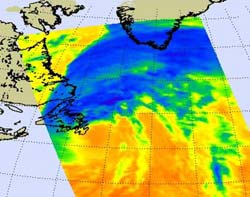
This infrared image of Hurricane Igor\'s cold (blue) thunderstorms was taken from NASA\'s Aqua satellite on Sept. 21 at 1553 UTC (11:53 a.m. EDT) as he was moving north into the Labrador Sea toward Labrador and Baffin Island. Igor\'s clouds extended into southern Greenland. Credit: NASA/JPL, Ed Olsen<br>
NASA's Terra and Aqua satellites captured visible and infrared images of Hurricane Igor yesterday as he brought heavy rainfall into northeastern Canada. A visible image of Hurricane Igor over Newfoundland, Canada was captured by the Moderate Resolution Imaging Spectroradiometer (MODIS) instrument on NASA's Terra satellite on Sept. 21 at 14:15 UTC (10:15 a.m. EDT). At that time, Igor had re-strengthened and an eye appeared on the visible imagery.
One and a half hours later, at 1553 UTC (11:53 a.m. EDT), NASA's Aqua satellite captured an infrared image of Hurricane Igor's cold thunderstorms that extended from Labrador, Canada eastward over southern Greenland. Igor was moving northward toward into the Labrador Sea toward Labrador and Baffin Island.
At 5 p.m. EDT on Sept. 21, Igor completed its post-tropical transition and its core went from a warm core, tropical system to a cold core system. At that time, he was 125 miles north-northeast of St. Johns, Newfoundland, Canada near 49.3 North and 51.7 West. Igor still had sustained hurricane-force winds of 80 mph although they are expected to weaken today, Sept. 22. Igor's minimum central pressure was 950 millibars, and he was moving north-northeast near a super-speedy 39 mph!
As Igor moved north his circulation continued increase. By 5 p.m. EDT on Sept. 21, tropical-storm force winds extended outward up to 520 miles from its center making the system over 1,000 miles wide!
Environment Canada noted that Hurricane Igor passed just south and east of Newfoundland on Tuesday, Sept. 21 and brought heavy rain and strong winds. Heavy rainfall extended far north and west of Igor's center as it neared Newfoundland, and hurricane-force winds were reported even into the evening.
A trough of low pressure (an elongated area of low pressure) that had passed over Newfoundland the day before (Monday) Igor arrived was still in the vicinity and interacted with the hurricane. The trough took moisture and energy from Igor and caused more heavy rainfall over the region. There were reports of extensive flooding, power outages and wind damage throughout the eastern half of Newfoundland over the last two days. Igor is one storm that the Atlantic will not miss.
Media Contact
More Information:
http://www.nasa.govAll latest news from the category: Earth Sciences
Earth Sciences (also referred to as Geosciences), which deals with basic issues surrounding our planet, plays a vital role in the area of energy and raw materials supply.
Earth Sciences comprises subjects such as geology, geography, geological informatics, paleontology, mineralogy, petrography, crystallography, geophysics, geodesy, glaciology, cartography, photogrammetry, meteorology and seismology, early-warning systems, earthquake research and polar research.


Newest articles

Silicon Carbide Innovation Alliance to drive industrial-scale semiconductor work
Known for its ability to withstand extreme environments and high voltages, silicon carbide (SiC) is a semiconducting material made up of silicon and carbon atoms arranged into crystals that is…

New SPECT/CT technique shows impressive biomarker identification
…offers increased access for prostate cancer patients. A novel SPECT/CT acquisition method can accurately detect radiopharmaceutical biodistribution in a convenient manner for prostate cancer patients, opening the door for more…

How 3D printers can give robots a soft touch
Soft skin coverings and touch sensors have emerged as a promising feature for robots that are both safer and more intuitive for human interaction, but they are expensive and difficult…

