Great opportunities for marine research with new underwater vehicle
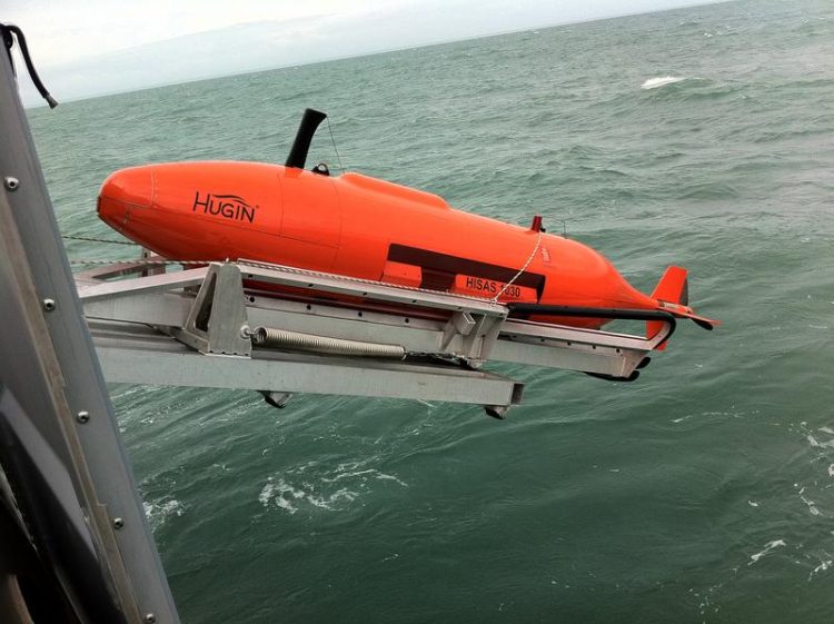
AUV, Autonomous Underwater Vehicle
After more than two years of preparation, the University of Gothenburg has signed a contract that will make Sweden’s first autonomous underwater vehicle for research use a reality.
“This underwater vessel will enable us to do research in areas that we have been unable to reach so far, such as underneath glaciers in Antarctica that are 500 metres thick and beneath the Arctic sea ice”, says Anna Wåhlin, a professor of oceanography at the University of Gothenburg.
Enabling detailed studies of the seabed
The vessel is known as an AUV, Autonomous Underwater Vehicle. It is an unmanned, autonomous submarine equipped with a range of instruments and sensors capable of mapping the marine environment and measuring the ocean’s chemistry, physics and biology.
With the craft, detailed studies can be carried out at great depths in the oceans. The submarine operates independently and can be sent out on missions under the control of a mothership, where scientists can also be working on other investigations.
“To measure the marine environment to the extent necessary for understanding how the ocean works, we must make use of autonomous observation platforms on a much larger scale. Future research vessels will serve as motherships for many different autonomous vehicles, with our AUV being one of the largest and most complex.”
Large areas of the seabed can be surveyed
The new underwater vessel will be able to descend to a depth of 3,000 metres and cover a range of about 200-300 km. It is equipped with a new state-of-the-art navigation system that makes it possible to operate for long distances under water and simultaneously know where it is, a major challenge for craft below the surface of the ocean since signals from satellites or GPS cannot penetrate water. It is equipped with instruments that can be used to survey large areas of the seabed and ice in great detail. It also will have sonar that penetrates the floor of the ocean and reveals the nature of sedimentation in the past.
“That information can be used to tell how the climate has changed throughout history and how the edge of the ice has moved. In addition, the AUV will have ultramodern equipment to measure ocean currents, temperature, carbon dioxide, chlorophyll, nitrates and oxygen, among other things.”
Permits study of climate in the past
With the help of these instruments, scientists will be able to chart the ocean floor with such great resolution that they can determine the type of seabed, if it is clay or if coral grows there, and detect various types of phenomena such as contourites (convoluted sedimentary deposits on the seabed).
By peering into the seabed and sedimentation, scientists can also study the climate thousands of years back in time, conduct detailed studies of ocean currents and their chemistry and biology, and survey large areas of the ocean covered by ice. This will help calibrate the satellites that measure the expanse and thickness of ice. The underwater craft also will be used for investigations of water closer to Sweden – in the Skagerrak and the Baltic Sea, for example.
The Autonomous Underwater Vehicle is a national infrastructure, funded by a grant from the Knut and Alice Wallenberg Foundation and managed by a project team with representatives from the University of Gothenburg, Chalmers University of Technology and Stockholm University. The contract with the Norwegian company Kongsberg AS has now been signed. The underwater vehicle is expected to be in operation next year at the latest.
Contact:
Anna Wåhlin. Professor at the University of Gothenburg
anna.wahlin@marine.gu.se, +46 (0)31-786 2866
Photo: Kongsberg AS
Portrait Anna Wåhlin, Malin Arnesson
http://science.gu.se/english/News/News_detail//great-opportunities-for-marine-re…
Media Contact
All latest news from the category: Earth Sciences
Earth Sciences (also referred to as Geosciences), which deals with basic issues surrounding our planet, plays a vital role in the area of energy and raw materials supply.
Earth Sciences comprises subjects such as geology, geography, geological informatics, paleontology, mineralogy, petrography, crystallography, geophysics, geodesy, glaciology, cartography, photogrammetry, meteorology and seismology, early-warning systems, earthquake research and polar research.


Newest articles

Properties of new materials for microchips
… can now be measured well. Reseachers of Delft University of Technology demonstrated measuring performance properties of ultrathin silicon membranes. Making ever smaller and more powerful chips requires new ultrathin…

Floating solar’s potential
… to support sustainable development by addressing climate, water, and energy goals holistically. A new study published this week in Nature Energy raises the potential for floating solar photovoltaics (FPV)…

Skyrmions move at record speeds
… a step towards the computing of the future. An international research team led by scientists from the CNRS1 has discovered that the magnetic nanobubbles2 known as skyrmions can be…

