Google Earth Ocean Terrain Receives Major Update
Scripps Institution of Oceanography / University of California, San Diego
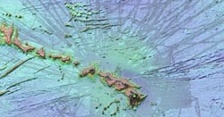
Internet information giant Google updated ocean data in its Google Earth application this week, reflecting new bathymetry data assembled by Scripps Institution of Oceanography, UC San Diego, NOAA researchers and many other ocean mapping groups from around the world.
The newest version of Google Earth includes more accurate imagery in several key areas of ocean using data collected by research cruises over the past three years.
“The original version of Google Ocean was a newly developed prototype map that had high resolution but also contained thousands of blunders related to the original archived ship data,” said David Sandwell, a Scripps geophysicist. “UCSD undergraduate students spent the past three years identifying and correcting the blunders as well as adding all the multibeam echosounder data archived at the National Geophysical Data Center in Boulder, Colorado.”
“The Google map now matches the map used in the research community, which makes the Google Earth program much more useful as a tool for planning cruises to uncharted areas,” Sandwell added.
For example, the updated, more precise data corrects a grid-like artifact on the seafloor that was misinterpreted in the popular press as evidence of the lost city of Atlantis off the coast of North Africa.
Through several rounds of upgrades, Google Earth now has 15 percent of the seafloor image derived from shipboard soundings at 1-kilometer resolution. Previous versions only derived about 10 percent of their data from ship soundings and the rest from depths predicted by Sandwell and NOAA researcher Walter Smith using satellite gravity measurements. The two developed the prediction technique in 1994. The satellite and sounding data are combined with land topography from the NASA Shuttle Radar Topography Mission (SRTM) to create a global topography and bathymetry grid called SRTM30_PLUS.
This new version includes all of the multibeam bathymetry data collected by U.S. research vessels over the past three decades including 287 Scripps expeditions from research vessels Washington, Melville and Revelle. UCSD undergraduate student Alexis Shakas processed all the U.S. multibeam data and then worked with Google researchers on the global integration.
The next major upgrade to the grid will occur later this year using a new gravity model having twice the accuracy of previous models. The new gravity information is being collected by a European Space Agency satellite called CryoSat that was launched in February 2010.
Note to broadcast and cable producers: University of California, San Diego provides an on-campus satellite uplink facility for live or pre-recorded television interviews. Please phone or e-mail the media contact listed above to arrange an interview.
About Scripps Institution of Oceanography
Scripps Institution of Oceanography at University of California, San Diego, is one of the oldest, largest and most important centers for global science research and education in the world. Now in its second century of discovery, the scientific scope of the institution has grown to include biological, physical, chemical, geological, geophysical and atmospheric studies of the earth as a system. Hundreds of research programs covering a wide range of scientific areas are under way today in 65 countries. The institution has a staff of about 1,400, and annual expenditures of approximately $170 million from federal, state and private sources. Scripps operates robotic networks, and one of the largest U.S. academic fleets with four oceanographic research ships and one research platform for worldwide exploration. Birch Aquarium at Scripps serves as the interpretive center of the institution and showcases Scripps research and a diverse array of marine life through exhibits and programming for more than 415,000 visitors each year.
Media Contact
All latest news from the category: Earth Sciences
Earth Sciences (also referred to as Geosciences), which deals with basic issues surrounding our planet, plays a vital role in the area of energy and raw materials supply.
Earth Sciences comprises subjects such as geology, geography, geological informatics, paleontology, mineralogy, petrography, crystallography, geophysics, geodesy, glaciology, cartography, photogrammetry, meteorology and seismology, early-warning systems, earthquake research and polar research.


Newest articles
Advanced Brain Science Without Coding Expertise
Researchers at Helmholtz Munich and the LMU University Hospital Munich introduce DELiVR, offering a new AI-based approach to the complex task of brain cell mapping. The deep learning tool democratizes…

Bringing bio-inspired robots to life
Nebraska researcher Eric Markvicka gets NSF CAREER Award to pursue manufacture of novel materials for soft robotics and stretchable electronics. Engineers are increasingly eager to develop robots that mimic the…

Bella moths use poison to attract mates
Scientists are closer to finding out how. Pyrrolizidine alkaloids are as bitter and toxic as they are hard to pronounce. They’re produced by several different types of plants and are…

