Global Climate Trend Since Nov. 16, 1978: +0.14 C Per Decade
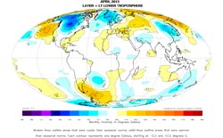
The University of Alabama in Huntsville<br><br>April 2013 map <br>
Global composite temp.: +0.10 C (about 0.18 degrees Fahrenheit) above 30-year average for April.
Northern Hemisphere: +0.12 C (about 0.22 degrees Fahrenheit) above 30-year average for April.
Southern Hemisphere: +0.09 C (about 0.16 degrees Fahrenheit) above 30-year average for April.
Tropics: +0.17 C (about 0.31 degrees Fahrenheit) above 30-year average for April.
March temperatures (revised):
Global Composite: +0.18 C above 30-year average
Northern Hemisphere: +0.33 C above 30-year average
Southern Hemisphere: +0.04 C above 30-year average
Tropics: +0.23 C above 30-year average
(All temperature anomalies are based on a 30-year average (1981-2010) for the month reported.)
Notes on data released May 6, 2013:
Compared to seasonal norms, during April the coldest area on the globe was in the southeastern portion of Saskatchewan, Canada, where the average temperature was as much as 4.82 C (about 8.7 degrees Fahrenheit) cooler than seasonal norms. Compared to seasonal norms, the “warmest” area on the globe in April was on the northeastern Russian coast near the Bering Sea. Temperatures there averaged 4.51 C (about 8.1 degrees Fahrenheit) warmer than seasonal norms for April.
Archived color maps of local temperature anomalies are available on-line at:
http://nsstc.uah.edu/climate/
The processed temperature data is available on-line at:
vortex.nsstc.uah.edu/data/msu/t2lt/uahncdc.lt
As part of an ongoing joint project between UAHuntsville, NOAA and NASA, John Christy, a professor of atmospheric science and director of the Earth System Science Center (ESSC) at The University of Alabama in Huntsville, and Dr. Roy Spencer, an ESSC principal scientist, use data gathered by advanced microwave sounding units on NOAA and NASA satellites to get accurate temperature readings for almost all regions of the Earth. This includes remote desert, ocean and rain forest areas where reliable climate data are not otherwise available.
The satellite-based instruments measure the temperature of the atmosphere from the surface up to an altitude of about eight kilometers above sea level. Once the monthly temperature data is collected and processed, it is placed in a “public” computer file for immediate access by atmospheric scientists in the U.S. and abroad.
Neither Christy nor Spencer receives any research support or funding from oil, coal or industrial companies or organizations, or from any private or special interest groups. All of their climate research funding comes from federal and state grants or contracts.
Media Contact
More Information:
http://www.uah.eduAll latest news from the category: Earth Sciences
Earth Sciences (also referred to as Geosciences), which deals with basic issues surrounding our planet, plays a vital role in the area of energy and raw materials supply.
Earth Sciences comprises subjects such as geology, geography, geological informatics, paleontology, mineralogy, petrography, crystallography, geophysics, geodesy, glaciology, cartography, photogrammetry, meteorology and seismology, early-warning systems, earthquake research and polar research.


Newest articles

Bringing bio-inspired robots to life
Nebraska researcher Eric Markvicka gets NSF CAREER Award to pursue manufacture of novel materials for soft robotics and stretchable electronics. Engineers are increasingly eager to develop robots that mimic the…

Bella moths use poison to attract mates
Scientists are closer to finding out how. Pyrrolizidine alkaloids are as bitter and toxic as they are hard to pronounce. They’re produced by several different types of plants and are…

AI tool creates ‘synthetic’ images of cells
…for enhanced microscopy analysis. Observing individual cells through microscopes can reveal a range of important cell biological phenomena that frequently play a role in human diseases, but the process of…

