First Eastern Pacific tropical depression runs ahead of dawn
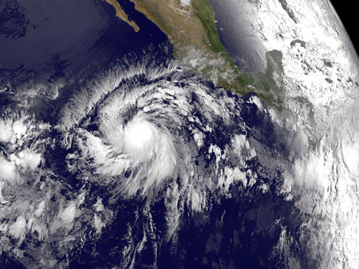
NOAA's GOES-West satellite captured an infrared image of the developing depression on May 28 at 1200 UTC (8 a.m. EDT). The GOES image showed a circular center with bands of thunderstorms spiraling into the center from the northwest and southeast. Credits: NASA/NOAA GOES Project
An image of the storm taken from NOAA's GOES-West satellite shows the depression in infrared light as it was born in the early morning hours before sunrise.
To the east of the depression, the GOES image shows the sunlight of dawn reaching Mexico's Yucatan Peninsula.
At 0900 UTC (5 a.m. EDT) the center of Tropical Depression One-E was located near latitude 11.0 North, longitude 110.4 West, ABOUT 685 miles (1,105 km) southwest of Manzanillo Mexico.
The depression is moving toward the west-northwest near 15 mph (24 km/h), but a decrease in forward speed is expected to begin later today.
Maximum sustained winds were near 35 mph (55 km/h) with higher gusts and it is expected to become a tropical storm later today, May 28 and could become a hurricane by late Friday.
The estimated minimum central pressure is 1005 millibars (29.68 inches).
NOAA's GOES-West satellite captured an infrared image of the developing depression on May 28 at 1200 UTC (8 a.m. EDT). The GOES image showed a circular center with bands of thunderstorms spiraling into the center from the northwest and southeast.
The National Hurricane Center (NHC) forecast said that the depression should turn toward the northwest by tonight and the north-northwest by Friday night remaining over open ocean.
Media Contact
All latest news from the category: Earth Sciences
Earth Sciences (also referred to as Geosciences), which deals with basic issues surrounding our planet, plays a vital role in the area of energy and raw materials supply.
Earth Sciences comprises subjects such as geology, geography, geological informatics, paleontology, mineralogy, petrography, crystallography, geophysics, geodesy, glaciology, cartography, photogrammetry, meteorology and seismology, early-warning systems, earthquake research and polar research.


Newest articles

Silicon Carbide Innovation Alliance to drive industrial-scale semiconductor work
Known for its ability to withstand extreme environments and high voltages, silicon carbide (SiC) is a semiconducting material made up of silicon and carbon atoms arranged into crystals that is…

New SPECT/CT technique shows impressive biomarker identification
…offers increased access for prostate cancer patients. A novel SPECT/CT acquisition method can accurately detect radiopharmaceutical biodistribution in a convenient manner for prostate cancer patients, opening the door for more…

How 3D printers can give robots a soft touch
Soft skin coverings and touch sensors have emerged as a promising feature for robots that are both safer and more intuitive for human interaction, but they are expensive and difficult…

