Did a volcanic cataclysm 40,000 years ago trigger the final demise of the Neanderthals?
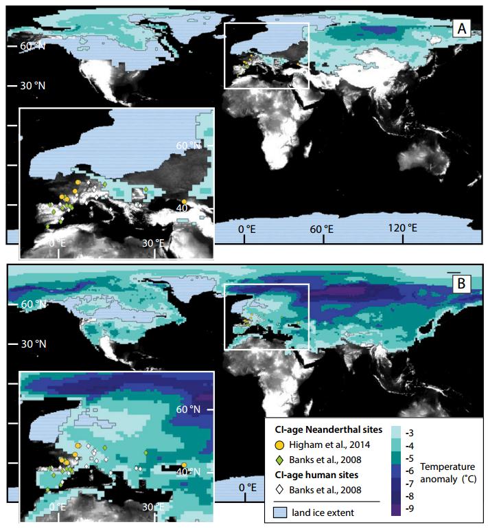
Figure 4 in B.A. Black et al.: This image shows annually averaged temperature anomalies in excess of 3°C for the first year after the Campanian Ignimbrite (CI) eruption compared with spatial distribution of hominin sites with radiocarbon ages close to that of the eruption. Credit: B.A. Black et al. and the journal Geology
The Campanian Ignimbrite (CI) eruption in Italy 40,000 years ago was one of the largest volcanic cataclysms in Europe and injected a significant amount of sulfur-dioxide (SO2) into the stratosphere. Scientists have long debated whether this eruption contributed to the final extinction of the Neanderthals. This new study by Benjamin A. Black and colleagues tests this hypothesis with a sophisticated climate model.
Black and colleagues write that the CI eruption approximately coincided with the final decline of Neanderthals as well as with dramatic territorial and cultural advances among anatomically modern humans. Because of this, the roles of climate, hominin competition, and volcanic sulfur cooling and acid deposition have been vigorously debated as causes of Neanderthal extinction.
They point out, however, that the decline of Neanderthals in Europe began well before the CI eruption: “Radiocarbon dating has shown that at the time of the CI eruption, anatomically modern humans had already arrived in Europe, and the range of Neanderthals had steadily diminished. Work at five sites in the Mediterranean indicates that anatomically modern humans were established in these locations by then as well.”
“While the precise implications of the CI eruption for cultures and livelihoods are best understood in the context of archaeological data sets,” write Black and colleagues, the results of their study quantitatively describe the magnitude and distribution of the volcanic cooling and acid deposition that ancient hominin communities experienced coincident with the final decline of the Neanderthals.
In their climate simulations, Black and colleagues found that the largest temperature decreases after the eruption occurred in Eastern Europe and Asia and sidestepped the areas where the final Neanderthal populations were living (Western Europe). Therefore, the authors conclude that the eruption was probably insufficient to trigger Neanderthal extinction.
However, the abrupt cold spell that followed the eruption would still have significantly impacted day-to-day life for Neanderthals and early humans in Europe. Black and colleagues point out that temperatures in Western Europe would have decreased by an average of 2 to 4 degrees Celsius during the year following the eruption. These unusual conditions, they write, may have directly influenced survival and day-to-day life for Neanderthals and anatomically modern humans alike, and emphasize the resilience of anatomically modern humans in the face of abrupt and adverse changes in the environment.
FEATURED ARTICLE
Campanian Ignimbrite volcanism, climate, and the final decline of the Neanderthals
Benjamin A. Black et al., University of California, Berkeley, California, USA. Published online ahead of print on 19 March 2015; http://dx.
Other recently posted GEOLOGY articles (see below) cover such topics as
- 1. Isostatic rebound, the Baltic Sea, and paleo-shorlines;
- 2. How “uplift sowed the seeds of its own destruction” in the Western Alps;
- 3. Glacial changes in the central Brooks Range, Alaska; and
- 4. EarthScope seismology in the southern Appalachians.
GEOLOGY articles published online ahead of print can be accessed online at http://geology.
Please discuss articles of interest with the authors before publishing stories on their work, and please make reference to GEOLOGY in articles published. Contact Kea Giles for additional information or assistance.
Non-media requests for articles may be directed to GSA Sales and Service, gsaservice@geosociety.org.
Glacio-isostatic control on hypoxia in a high-latitude shelf basin
Tom Jilbert et al., Utrecht University, Utrecht, Netherlands; current: University of Helsinki, Helsinki, Finland. Published online ahead of print on 19 March 2015; http://dx.
“Isostatic rebound” describes the rise of land masses that were previously buried under ice. The last ice age terminated rapidly, leaving crustal depressions in high latitude regions that continue to rebound today. Vertical motion of the crust has a strong effect on coastlines and the geometry of shelf seas such as the Baltic Sea, Hudson Bay, and the St. Lawrence Estuary. These societally important marine environments are today sensitive to oxygen depletion and eutrophication, partly due to the restricted exchange of water masses with the global ocean. Tom Jilbert and colleagues put forward the idea that isostatic rebound has influenced the distribution of low-oxygen conditions in high-latitude shelf seas since the termination of the last ice age. By analyzing “proxies,” such as trace metals and cyanobacterial pigments in sediment cores, they show that some regions of the Baltic Sea have become more oxygenated over this interval, while others have remained vulnerable to oxygen depletion up to the present day. The authors use a paleo-shoreline model to reconstruct the geometry of the Baltic Sea since its inception 8000 years ago, and show that shallowing of straits between different regions of the Sea controlled the distribution of low-oxygen conditions through time.
Rapid exhumation in the Western Alps driven by slab detachment and glacial erosion
Matthew Fox et al., University of California, Berkeley, California, USA; and Berkeley Geochronology Center, Berkeley, California, USA; and ETH Zurich, Zurich, Switzerland. Published online ahead of print on 19 March 2015; http://dx.
This research addresses how, when, and why mountain landscapes form. In broad terms, mountain landscapes require two things: tectonic activity, usually generated by compression at plate-tectonic boundaries, that tends to increase their elevation; and the erosional effect of landslides, rivers, and glaciers, that tends to decrease elevation. We investigate the relative importance of these processes across the European Alps, using a technique called thermochronometry that allows us to determine the past thermal history of rocks. Because temperature increases with depth below Earth's surface, we can interpret the cooling history of a rock as the history of how erosion brought that rock to Earth's surface. We put together more than 2,500 thermochronometric ages collected by many studies in the past 30 years to explore, with detail and resolution not previously possible, how erosion rates changed in space and time during the past 35 million years. We find that renewed uplift across the Western Alps has triggered a response in glacier formation and activity; glacial activity has eroded the mountains at a rate two or three times higher than prior to uplift or in the neighboring regions to the east. The consequence is that the uplift sowed the seeds of its own destruction.
Rapid and early deglaciation in the central Brooks Range, Arctic Alaska
Simon L. Pendleton et al., University at Buffalo, Buffalo, New York, USA; current: University of Colorado, Boulder, Colorado, USA. Published online ahead of print on 19 March 2015; http://dx.
We applied an isotopic dating technique to glacial landforms in the central Brooks Range, Alaska, to reconstruct the most complete history of glacier changes since the end of the last Ice Age. We found that glaciers began retreating about 21,000 years ago. We hypothesize that retreat was due to increasing insolation and the redirection of warm southerly air masses over the region by the massive Laurentide Ice Sheet over Canada. A decrease in Laurentide Ice sheet size beginning about 19,000 years ago may have reversed warming in the region, causing glaciers to advance about 18,000 years ago. This was followed by a very rapid period of glacier retreat between 16,000 and 15,000 years ago, when glaciers all but disappeared from northern Alaska. We hypothesis that this was likely induced by the increase in global atmospheric CO2 concentrations around that time. Glaciers had since been small or completely absent until re-growth over the last 5000 years.
Constraining lithologic variability along the Alleghanian detachment in the southern Appalachians using passive-source seismology
E. Horry Parker, Jr., et al., University of Georgia, Athens, Georgia, USA. Published online ahead of print on 19 March 2015; http://dx.
The formation of the Appalachian Mountains resulted from the continental collision between Africa and North America ~325 million years ago. Previous seismic reflection investigations of the deep geologic structure of the southern Appalachians identified a laterally continuous subhorizontal detachment fault beneath the high elevations of the Blue Ridge and Inner Piedmont, implying that rocks at the surface were translated ~250 km to the northwest over the ancient continental margin. In this study, E. Horry Parker Jr. and colleagues analyze seismic waves generated by distant earthquakes from South America and the northern Pacific. The results from the EarthScope SESAME seismic array provide new constraints on the southeastward extension of the Appalachian detachment and nature of the rocks along the fault zone. The new data are consistent with the hypothesis that sedimentary rocks originally deposited on the ancient North American margin underlie the highly metamorphosed rocks visible at the surface. The study also provides strong evidence that the Appalachian detachment extends southeastward beneath the Carolina terrane, an assemblage of rocks formed in a volcanic arc system, and later thrust over the continental margin.
Intense and widespread seismicity during the end-Triassic mass extinction due to emplacement of a large igneous province
Sofie Lindström et al., GEUS Geological Survey of Denmark and Greenland, Copenhagen, Denmark. Published online ahead of print on 19 March 2015; http://dx.
The end-Triassic mass extinction (201.6 million years ago) is generally explained by global warming and ocean acidification caused by CO2 and/or methane released from massive volcanism in the Central Atlantic magmatic province (CAMP). In the United Kingdom, the extinction beds also contain conspicuous disturbed sediments — seismites — originally interpreted as formed by a single seismic shock from an unknown extraterrestrial impact. In this study, Lindström and colleagues instead demonstrate that ~950,000 km2 of northwest Europe was repeatedly affected by intense seismic activity during the ~20,000-year-duration of the biotic crisis. The repetitive nature of the seismites negates formation by an extraterrestrial bolide impact. Instead, the seismites are linked to tectonic activity in connection to CAMP formation. The most intense seismic phase coincided with major terrestrial ecosystem disturbances, indicating deforestation and soil erosion, and appears to have ceased prior to the largest CO2/methane release. This, together with lack of evidence for continued seismicity in the Early Jurassic during the 600.000 years of ongoing extrusive CAMP volcanism, suggests that magmatic intrusions into sedimentary rocks during an initial phase of the CAMP played a part in the extinction. Such intrusions may form gases (e.g. SO2, halocarbons and PAHs) that are deleterious to living organisms.
Deformed monazite yields high-temperature tectonic ages
T.M. Erickson et al., Curtin University of Technology, Perth, Western Australia, Australia. Published online ahead of print on 19 March 2015; http://dx.
This paper reports the first detailed analysis of plastic deformation in natural monazite, a common accessory mineral in high-grade metamorphic rocks from the mid to lower crust. The analyzed sample comes from a granulite of the Sandamata Complex of Rajasthan, India. We use high-spatial resolution mapping of the crystallographic orientation of the monazite lattice to characterize a range of microstructures (twins, low-angle grain boundaries and recrystallized neoblasts) that formed as a response to tectonic stresses applied to the grain over a billion years ago. Ion probe U-Pb dating of the different microstructural types indicates a systematic variation in ages with the microstructures. One type of microstructure (neoblastic monazite), formed by the nucleation of new grains and subsequent growth by grain boundary migration, is shown to have completely reset U-Pb ages. This allows the ages from these domains to be used to constrain the timing of tectonic deformation of the host rock. Our results provide valuable constraints on the tectonic evolution of the Sandamata Complex, but, more importantly, also indicate that the application of integrated microstructural analysis and high spatial resolution U-Pb geochronology to monazite provides a new approach to dating high temperature deformation in the deep crust.
Mid-Cretaceous High Arctic stratigraphy, climate, and Oceanic Anoxic Events
Jens O. Herrle et al., Goethe-University Frankfurt, Biodiversity and Climate Research Centre (BIK-F), Frankfurt am Main, Germany. Published online ahead of print on 19 March 2015; http://dx.
There is ample information on major marine environmental and evolutionary change during the Cretaceous (145 to 66 million years ago) from the low- to mid-latitudes. However, knowledge of the role of Cretaceous High Arctic climate and oceanographic changes in the Arctic Amerasian and Sverdrup basins is still limited because of its difficult accessibility. Only the Canadian High Arctic Sverdrup Basin provides accessible Cretaceous sections and thus is a natural laboratory to unravel the marine climate and ecosystem evolution of the Canadian High Arctic. By using a bio- and chemostratigraphic approach, Jens Herrle and colleagues recorded, for the first time, in a single organic-rich marine sedimentary succession at Glacier Fiord on Axel Heiberg Island in the High Arctic Sverdrup Basin, the timing and magnitude of most major Oceanic Anoxic Events (OAEs) in brackish-water (OAE1a) and shelf (OAE1b and OAE2) settings. They demonstrate that the occurrence of upper Aptian to lowermost Albian glendonite beds within the Polar Sea is coeval with a subtropical Atlantic drop in sea-surface temperatures of ~4 degrees C. Thus, their data support the presence of cool shelf waters in the High Arctic at this time.
Volatile budget of Tenerife phonolites inferred from textural zonation of S-rich haüyne
Lauren B. Cooper et al., Institute of Geochemistry and Petrology, ETH Zurich, Zurich, Switzerland. Published online ahead of print on 19 March 2015; http://dx.
In this paper, we use complex textural zonation patterns within haüyne phenocrysts in phonolites from Las Can?adas volcano, Tenerife, Canary Islands, Spain, to explain gas transfer processes occurring in magmatic reservoirs. This work has implications for understanding the origin of the well-known, but poorly understood, “excess S” problem, where more S is emitted from a volcano than can be accounted for by the erupted magma. In total, five textural zones were identified within haüyne, using several microscopy and spectroscopy methods. We propose that the distinctive zones are related to variable rates of haüyne crystallization and may be linked to the degassing state of the magmatic system. For example, fluid inclusion-rich zones within haüyne document the upward percolation of a low-density magmatic fluid phase into the erupted reservoir. Such zones attest to the extreme wetting property of haüyne and provide direct physical evidence that the magma was fluid saturated during rapid haüyne growth. Although phonolitic systems, such as Tenerife, do not typically produce large excess S emissions, the gas transfer processes recorded in phonolitic haüyne should be applicable to intermediate-silicic systems devoid of haüyne, but with much larger S excesses.
Mismatch of glacier extent and summer insolation in Southern Hemisphere mid-latitudes
Alice M. Doughty et al., Dartmouth College, Hanover, New Hampshire, USA and School of Earth and Climate Sciences and Climate Change Institute, University of Maine, Orono, Maine, USA. Published online ahead of print on 19 March 2015; http://dx.
Despite being widely accepted, some difficulties remain with the Milankovitch theory of climate. Cyclic fluctuations in solar radiation intensity due to wobbles in Earth's orbit are thought to influence the growth and demise of Northern Hemisphere continental ice sheets during glaciations, but should have an opposite effect on Southern Hemisphere glaciers. Detailed mapping and surface exposure dating of ice-age glacier moraine landforms in New Zealand's Southern Alps, targeting the cosmogenic isotope 10Be, has identified at least seven episodes of maximal glacier expansion during the last ice age. Five maxima have been identified in the moraine belts impounding Lake Pukaki, dated at 41,760 years plus or minus 1090; 35,500 years plus or minus 1260; 27,170 years plus or minus 680; 20,270 years plus or minus 600; and 18,290 years plus or minus 490, and moraine belts at nearby Lake Ohau record two more glacier maxima, at 32,520 years plus or minus 970 and 22,510 years plus or minus 660. There is no consistent relationship between these seven maxima and orbitally induced variations in solar radiation intensity, but there is close similarity between the expansion and contraction of these southern glaciers and nearby sea surface temperature records obtained from offshore marine sediment cores. Further inquiry is needed into inter-hemispheric linkages between climatic patterns and orbital variations.
Global increase in plant carbon isotope fractionation following the Last Glacial Maximum caused by increase in atmospheric pCO2
Brian A. Schubert, University of Louisiana at Lafayette, Lafayette, Louisiana, USA; and A. Hope Jahren, University of Hawaii at M?noa, Honolulu, Hawaii, USA. Published online ahead of print on 19 March 2015; http://dx.
Our study uses a global dataset of carbon isotope values measured in fossil leaves and organic matter to calculate carbon dioxide levels in the atmosphere during the last 30,000 years. Despite the widespread use of similar isotope data, the effect of changes in CO2 on carbon isotope values has never been separated from the climate signal. This work breaks new ground for using terrestrial carbon isotope records to reconstruct CO2 levels in the past, and shows that the change in carbon isotope values that we identify here is best interpreted as being caused by an increase in atmospheric CO2 levels. The work illustrates a need to revisit previous interpretations of climate and environmental change made using similar carbon isotope data, and provides a novel way to estimate Earth's climate sensitivity to changing levels of CO2 in the atmosphere.
###
Media Contact
All latest news from the category: Earth Sciences
Earth Sciences (also referred to as Geosciences), which deals with basic issues surrounding our planet, plays a vital role in the area of energy and raw materials supply.
Earth Sciences comprises subjects such as geology, geography, geological informatics, paleontology, mineralogy, petrography, crystallography, geophysics, geodesy, glaciology, cartography, photogrammetry, meteorology and seismology, early-warning systems, earthquake research and polar research.


Newest articles

Silicon Carbide Innovation Alliance to drive industrial-scale semiconductor work
Known for its ability to withstand extreme environments and high voltages, silicon carbide (SiC) is a semiconducting material made up of silicon and carbon atoms arranged into crystals that is…

New SPECT/CT technique shows impressive biomarker identification
…offers increased access for prostate cancer patients. A novel SPECT/CT acquisition method can accurately detect radiopharmaceutical biodistribution in a convenient manner for prostate cancer patients, opening the door for more…

How 3D printers can give robots a soft touch
Soft skin coverings and touch sensors have emerged as a promising feature for robots that are both safer and more intuitive for human interaction, but they are expensive and difficult…

