Citizen science campaign to aid disaster response
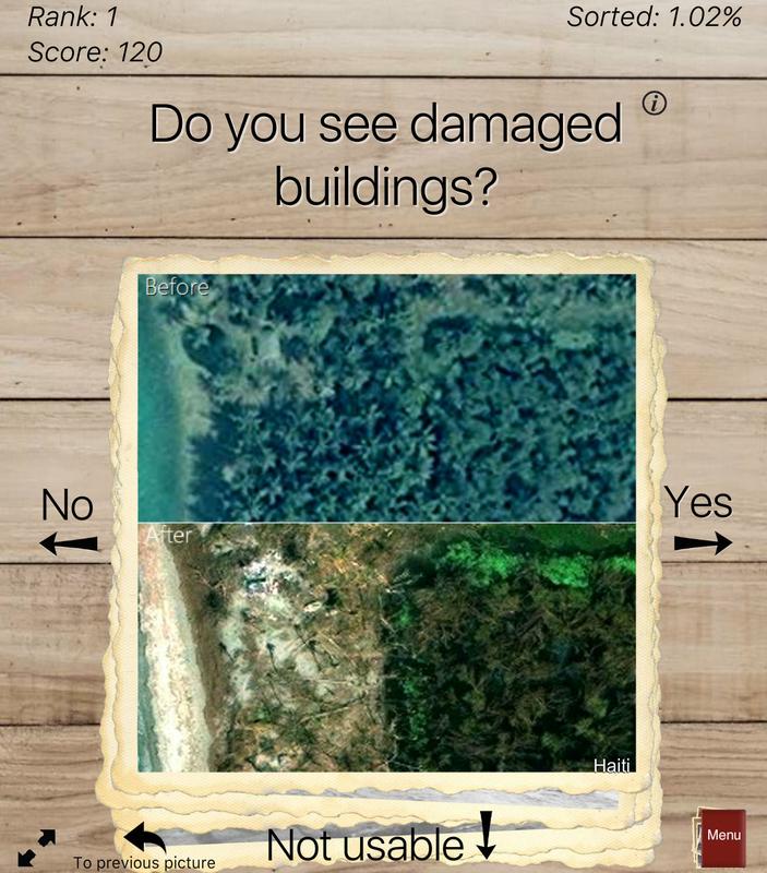
Screenshot from the Picture Pile app IIASA
After natural disasters, communities need fast access to damage assessment maps to aid relief, recovery and rebuilding efforts. On 28 April at the European Geosciences Union General Assembly (EGU), IIASA researchers will present a new way to link volunteers around the world with a way to help communities after major disasters. They invite the general public to test out the app for the next few weeks, using data from Hurricane Matthew, which devastated Haiti last year.
“Our goal is to provide a simple way for people to help disaster response efforts. At the same time, the app could help raise public awareness of natural disasters,” says IIASA researcher Olha Danylo, who is presenting the work at EGU.
The new campaign takes advantage of Picture Pile, an app for mobile phone, tablet, and computer, which has previously been used to crowdsource the mapping of deforestation in Tanzania. IIASA researchers have now redesigned the app to use satellite imagery provided by DigitalGlobe in partnership with the Humanitarian OpenStreetMap Team under the Crowd4Sat project with Imperative Space and the European Space Agency (ESA).
The app provides a simple platform for volunteers to classify differences between two satellite images. Volunteers are asked to look at before-disaster and post-disaster satellite images, noting in this case where they see damage to buildings. This sort of image processing is simple for a human being, but difficult to program into computer algorithms.
Because time is of the essence in such disaster response efforts, this initial public test will provide the researchers a chance to rapidly analyze app functionality, evaluate the data quality provided by volunteers, and make improvements before applying it in a real situation.
“This is kind of like a fire drill. When a disaster occurs, it’s important that we are able to respond quickly, that the app and data collection run smoothly, and that we know what quality of data to expect,” says IIASA researcher Steffen Fritz, who leads the institute’s citizen science team. “Hurricane Matthew, for example, damaged an estimated 200,000 homes in Haiti. The idea of this project is to help provide a quick initial damage assessment, so that help can also quickly reach those who need it.”
Led by Imperative Space in collaboration with IIASA and the Humanitarian OpenStreetMap Team, the project is a part of the ESA initiative Crowd4Sat, which combines citizen science with satellite observations in the fields of biodiversity & wildlife, environment and disaster relief.
Reference
Danylo O, Sturn T, Giovando C, Moorthy I, Fritz S, See L, Kapur R, Girardot B, Ajmar A, Tonolo FG, Reinicke T, Mathieu PP, Duerauer M (2017) Picture Pile: A citizen-powered tool for rapid post-disaster damage assessments. European Geophysical Union General Assembly 2017 EGU2017-19266
EGU session Fri, 28 Apr, 09:00–09:15, Room L2
About IIASA:
The International Institute for Applied Systems Analysis (IIASA) is an international scientific institute that conducts research into the critical issues of global environmental, economic, technological, and social change that we face in the twenty-first century. Our findings provide valuable options to policymakers to shape the future of our changing world. IIASA is independent and funded by prestigious research funding agencies in Africa, the Americas, Asia, Europe, and Oceania. www.iiasa.ac.at
About Imperative Space
Imperative Space (www.imperativespace.com) is an independent venture based in the UK specialising in innovative public engagement, education and creative communications projects for and about the space sector. Its work includes citizen science, online learning, data visualisation, data apps, video-led training, documentary films, interactive technology, exhibition design, consultancy and the development of international outreach initiatives. It has particular expertise in developing innovative applications and engagement initiatives using satellite Earth observation data, and leads the Crowd4Sat initiative (www.crowd4sat.org) for ESA. Imperative Space is a part of Imperative Communications (www.imperativecommunications.com), a company providing a similar range of services in other sectors facing pressing global challenges, including in climate change and the environment, education, sustainable development and public services.
TEST THE APP TODAY
Browser: http://geo-wiki.org/games/picturepile/
iPhone/iPad: https://itunes.apple.com/us/app/picture-pile/id926740054?ls=1&mt=8
GooglePlay: https://play.google.com/store/apps/details?id=air.PicturePile
Media Contact
All latest news from the category: Earth Sciences
Earth Sciences (also referred to as Geosciences), which deals with basic issues surrounding our planet, plays a vital role in the area of energy and raw materials supply.
Earth Sciences comprises subjects such as geology, geography, geological informatics, paleontology, mineralogy, petrography, crystallography, geophysics, geodesy, glaciology, cartography, photogrammetry, meteorology and seismology, early-warning systems, earthquake research and polar research.


Newest articles

Combatting disruptive ‘noise’ in quantum communication
In a significant milestone for quantum communication technology, an experiment has demonstrated how networks can be leveraged to combat disruptive ‘noise’ in quantum communications. The international effort led by researchers…

Stretchable quantum dot display
Intrinsically stretchable quantum dot-based light-emitting diodes achieved record-breaking performance. A team of South Korean scientists led by Professor KIM Dae-Hyeong of the Center for Nanoparticle Research within the Institute for…

Internet can achieve quantum speed with light saved as sound
Researchers at the University of Copenhagen’s Niels Bohr Institute have developed a new way to create quantum memory: A small drum can store data sent with light in its sonic…

