Category 4 Cyclone Giri hits Burma, NASA satellite sees heavy rainfall
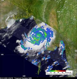
This TRMM rainfall rate image captured on Oct. 21 at 1534 UTC (11:34 a.m. EDT) shows moderate to heavy rain showers were surrounding Cyclone Giri\'s partially-formed eye. Red indicates heavy rainfall at more than 2 inches per hour. The yellow and green areas indicate moderate rainfall between .78 to 1.57 inches per hour.<br>Credit: NASA/SSAI, Hal Pierce<br><br><br>
Giri is the second tropical cyclone of 2010 to form in the Bay of Bengal and was seen by the Tropical Rainfall Measuring Mission (TRMM) satellite. Cyclone Giri was seen clearly by the TRMM satellite twice on Oct. 21.
The first good view was at 1534 UTC (11:34 a.m. EDT) when TRMM data showed a very well organized storm with heavy rainfall south of Giri's partially formed eye. The heaviest rainfall was falling at about 2 inches per hour, south of Giri's eye. The rainfall analysis was done at NASA's Goddard Space Flight Center, Greenbelt, Md.
The second TRMM orbit at 2347 UTC (7:47 p.m. EDT) captured Giri's rainfall when the wind speeds had increased to 85 knots (98 mph) making it a category two tropical cyclone on the Saffir-Simpson scale. The second TRMM image showed that Giri had developed a closed eye surrounded by powerful thunderstorms dropping heavy rainfall. Cyclone Giri then intensified to a category four tropical cyclone with wind speeds estimated at 125 knots (~144mph) before striking Burma's west coast in the middle of the morning.
On Oct. 22 at 1500 UTC (11 a.m. EDT) Cyclone Giri had maximum sustained winds near 135 knots (155 mph) and was weakening as it continued to move inland. Giri's center was about 180 nautical miles south-southeast of Chittagong, Bangladesh near 20.1 North and 93.7 East. It was moving north-northeast at 10 mph.
Satellite data also indicated that as Giri was making landfall, that it had a well-defined eye about 20 nautical miles wide. High waves, coastal erosion, severe winds of Category four hurricane force and very heavy rainfall are all being experienced along coastal areas of Hunters Bay and Combermere Bay. As Giri moves inland over the rugged terrain of Myanmar it will rapidly weaken and drop large amounts of rain.
Media Contact
More Information:
http://www.nasa.govAll latest news from the category: Earth Sciences
Earth Sciences (also referred to as Geosciences), which deals with basic issues surrounding our planet, plays a vital role in the area of energy and raw materials supply.
Earth Sciences comprises subjects such as geology, geography, geological informatics, paleontology, mineralogy, petrography, crystallography, geophysics, geodesy, glaciology, cartography, photogrammetry, meteorology and seismology, early-warning systems, earthquake research and polar research.


Newest articles

Silicon Carbide Innovation Alliance to drive industrial-scale semiconductor work
Known for its ability to withstand extreme environments and high voltages, silicon carbide (SiC) is a semiconducting material made up of silicon and carbon atoms arranged into crystals that is…

New SPECT/CT technique shows impressive biomarker identification
…offers increased access for prostate cancer patients. A novel SPECT/CT acquisition method can accurately detect radiopharmaceutical biodistribution in a convenient manner for prostate cancer patients, opening the door for more…

How 3D printers can give robots a soft touch
Soft skin coverings and touch sensors have emerged as a promising feature for robots that are both safer and more intuitive for human interaction, but they are expensive and difficult…

