California rising
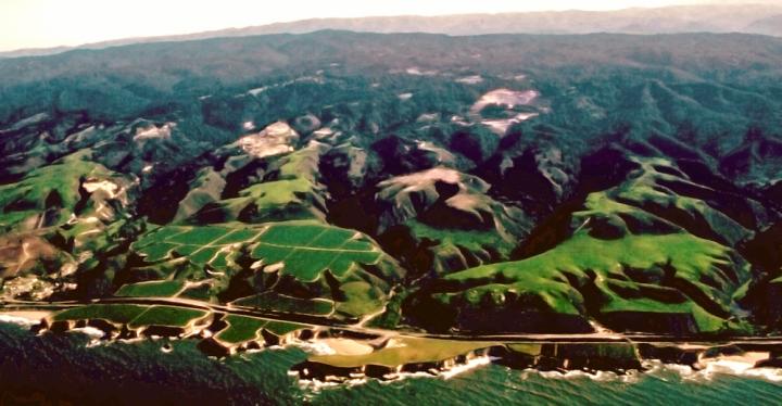
This aerial view shows the marine-terraced coastline of California north of Santa Cruz. Credit: Ramon Arrowsmith via Wikimedia Commons
For millions of years, the Pacific and North American plates have been sliding past — and crashing into — one another. This ongoing conflict creates uplift, the geological phenomenon that formed mountains along the west coast.
A new analysis by UC Santa Barbara earth scientist Alex Simms demonstrates that the Pacific coastlines of North America are not uplifting as rapidly as previously thought. The results appear in the journal Geological Society of America Bulletin.
“Current models overestimate uplift rates by an average of 40 percent,” said Simms, an associate professor in UCSB's Department of Earth Science. “They do not take into account glacio-isostatic adjustment, the Earth's response to the melting and growth of past ice sheets. Previous studies of the Pacific coast, including California, have ignored this when trying to use past sea levels to calculate uplift rates.”
Uplift is the vertical elevation of the Earth's surface in response to plate tectonics.
Scientists determine uplift rates by measuring marine terraces — flat mesas that indicate where the ocean level used to be — and comparing their elevations to geologic records of sea-level change. However, traditionally used “global” sea-level records come from places like the Huon Peninsula of Papua New Guinea, far away from the ice sheets that once covered Canada. That's a problem because the freezing of water into ice sheets and its subsequent thawing actually changed the shape of the Earth ever so slightly — and this deformation affects ocean levels.
According to Simms, the land responds the way a mattress does, indenting from weight and then relaxing back to its original shape. The Earth's gravitation field also changes in response to the building up and melting of these ice sheets. These changes to the land and Earth's gravity cause past sea levels to vary across the world. Most of this glacio-isostatic adjustment is not caused by current glacier melt but by the rebound of the Earth from the several-kilometer-thick ice sheets that covered much of Canada 20,000 years ago.
Simms and his colleagues compiled existing elevation measurement data from more than two dozen sites ranging from mid-Oregon to Baja California. They then recalculated uplift rates for each, applying a correction for glacio-isostatic adjustment.
Some areas are affected to a greater degree than others. The uplift rate for Punta Cabras in Baja California showed the largest difference: 72 percent lower than previous estimates. The rate for the San Diego area was reduced by 62 percent. For other areas, the rate changes were not as dramatic.
“Areas in Oregon are moving so fast that when you add the correction, the adjustment is much smaller: 10 to 20 percent,” Simms said. “If a site is going up 100 meters versus 90 meters, that's not a big change. Here, sea level changed differently because of the distance from where these big ice sheets used to be.”
This study provides one of the first spatially corrected sea-level records for California. “A 2012 study looked at one spot with one model, but we looked at variation across the state,” Simms explained. “Now our data can be applied not only in California but along the Pacific coast of North America.”
###
The study's co-authors are Hélène Rouby of the Laboratoire de Géologie de l'Ecole normale supérieure in Paris and Kurt Lambeck of The Australian National University in Canberra.
Media Contact
All latest news from the category: Earth Sciences
Earth Sciences (also referred to as Geosciences), which deals with basic issues surrounding our planet, plays a vital role in the area of energy and raw materials supply.
Earth Sciences comprises subjects such as geology, geography, geological informatics, paleontology, mineralogy, petrography, crystallography, geophysics, geodesy, glaciology, cartography, photogrammetry, meteorology and seismology, early-warning systems, earthquake research and polar research.


Newest articles

Bringing bio-inspired robots to life
Nebraska researcher Eric Markvicka gets NSF CAREER Award to pursue manufacture of novel materials for soft robotics and stretchable electronics. Engineers are increasingly eager to develop robots that mimic the…

Bella moths use poison to attract mates
Scientists are closer to finding out how. Pyrrolizidine alkaloids are as bitter and toxic as they are hard to pronounce. They’re produced by several different types of plants and are…

AI tool creates ‘synthetic’ images of cells
…for enhanced microscopy analysis. Observing individual cells through microscopes can reveal a range of important cell biological phenomena that frequently play a role in human diseases, but the process of…

