Better daily sea ice forecasts for the Arctic following CU-Boulder-led innovation
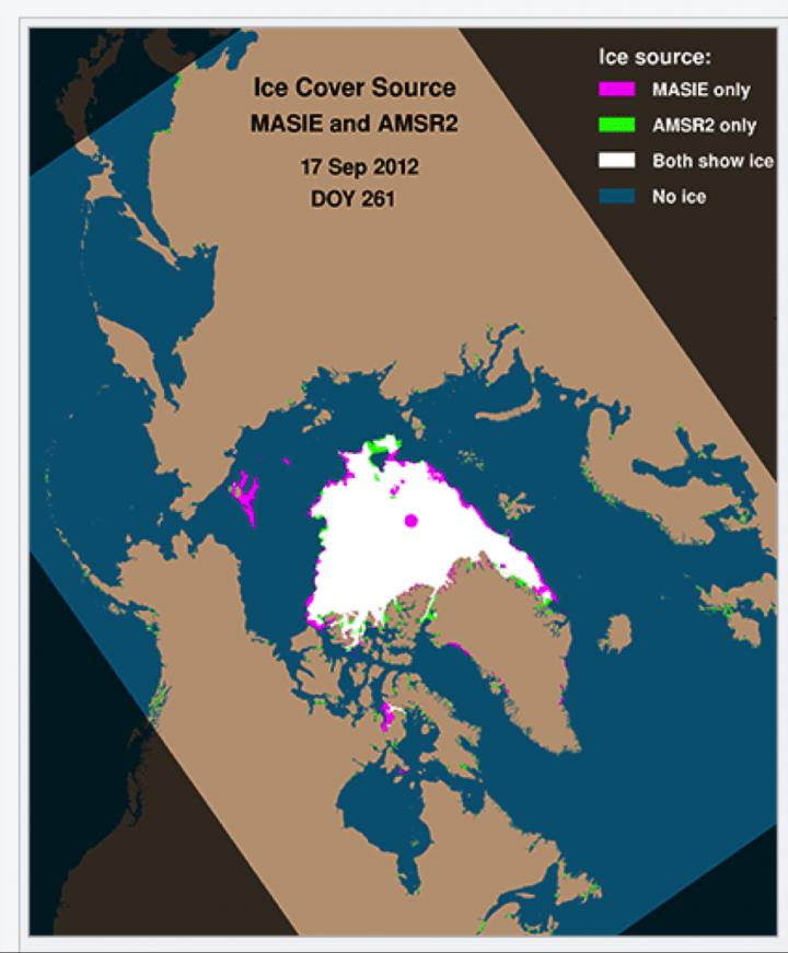
In this image, showing sea ice cover on a single summer day in 2012, pink areas represent sea ice not captured by the satellite-based microwave instrument AMSR2, but accurately captured by the MASIE product. During that summer, an energy company had to cease drilling operations in the Arctic because of unanticipated ice. A blend of MASIE and AMSR2 is used to make the new dataset of sea ice conditions that the forecast model uses. Credit: NSIDC
The Navy, the National Oceanic and Atmospheric Administration (NOAA) and others have been seeking to improve sea ice forecasts, said Pamela Posey of the U.S. Naval Research Laboratory (NRL) in Mississippi. In the remote Arctic, unanticipated sea ice can slow science research vessels and create problems for Navy submarines.
“It's especially important to have accurate forecasts given rapidly changing conditions in the Arctic,” Posey said.
The new system–which captures current sea-ice conditions more accurately and in greater detail by blending several streams of data–has been used operationally in Navy forecasting since February, Posey said. Florence Fetterer with the National Snow and Ice Data Center (NSIDC) and colleagues developed the blended input approach, and NRL has now shown it improves 6-hour forecast accuracy by 40 percent year-round. During the summer, forecasts improved even more than that, they reported in a paper in The Cryosphere, a journal of the European Geosciences Union.
NSIDC is part of the Cooperative Institute for Research in Environmental Sciences (CIRES) at the University of Colorado Boulder.
The new ingredients now going into the Navy's official sea ice forecasts are satellite data and human interpretation of sea ice presence or absence from satellite sources, said Pablo Clemente-Colón, Chief Scientist of the U.S. National Ice Center, a collaboration of the Navy, NOAA and the U.S. Coast Guard. “This is one of the first times that human analysis is ingested operationally into a major forecast model,” he said.
A couple years ago, Posey and others recognized that sea ice forecast models–used by Navy submarines, the U.S. Coast Guard and many others just as they use weather forecasts–had improved, with more detailed or “higher resolution” output. But just as with weather forecasts, these models have to start with accurate initial conditions, and observations of sea ice had not kept pace with models. The Naval Research Laboratory asked experts at NSIDC to see what could be done.
“Our idea was pretty simple, to combine two types of measurements,” said Fetterer, a CIRES scientist who is NSIDC's NOAA liaison. With colleagues from NASA, the National Ice Center and the Naval Research Laboratory, Fetterer blended data from the high-resolution satellite-based Advanced Microwave Scanning Radiometer 2 (AMSR2) with MASIE (“may-zee,” the Multisensor Analyzed Sea Ice Extent), itself a blended product that includes human interpretation of many satellite imagery sources as well as other information. The MASIE product often catches ice that the microwave data alone miss, especially in summer, when melt ponds on the surface of the ice appear as ocean to the sensor. Where there is ice, the AMSR product supplies an estimate of ice concentration that the forecast model needs.
The resulting high-resolution dataset can capture even small patches of sea ice a few miles across, which are easy to miss in some satellite datasets. That means better input into forecasts, and more accurate output, too. “We expect this combined product is going to do a much, much, much better job at initializing the Navy's forecast model,” Fetterer said.
The Navy used the new technique this summer as part of its support to the U.S. Coast Guard icebreaker Healy, which conducted missions in the Beaufort Sea with a transit to the North Pole to study biogeochemistry of Arctic waters. The Navy has used the blended product to provide sea ice forecasts at 2-km resolution since July 2015, Posey said.
“It is really helping us, and it's providing a better product for the whole community that uses and depends on accurate sea ice information from forecast modelers to anybody with assets in the Arctic,” Clemente-Colón said.
###
CIRES is a partnership of NOAA and CU-Boulder.
Media Contact
All latest news from the category: Earth Sciences
Earth Sciences (also referred to as Geosciences), which deals with basic issues surrounding our planet, plays a vital role in the area of energy and raw materials supply.
Earth Sciences comprises subjects such as geology, geography, geological informatics, paleontology, mineralogy, petrography, crystallography, geophysics, geodesy, glaciology, cartography, photogrammetry, meteorology and seismology, early-warning systems, earthquake research and polar research.


Newest articles

Silicon Carbide Innovation Alliance to drive industrial-scale semiconductor work
Known for its ability to withstand extreme environments and high voltages, silicon carbide (SiC) is a semiconducting material made up of silicon and carbon atoms arranged into crystals that is…

New SPECT/CT technique shows impressive biomarker identification
…offers increased access for prostate cancer patients. A novel SPECT/CT acquisition method can accurately detect radiopharmaceutical biodistribution in a convenient manner for prostate cancer patients, opening the door for more…

How 3D printers can give robots a soft touch
Soft skin coverings and touch sensors have emerged as a promising feature for robots that are both safer and more intuitive for human interaction, but they are expensive and difficult…

