A NASA infrared look at the Southern Indian Ocean's 15th tropical cyclone
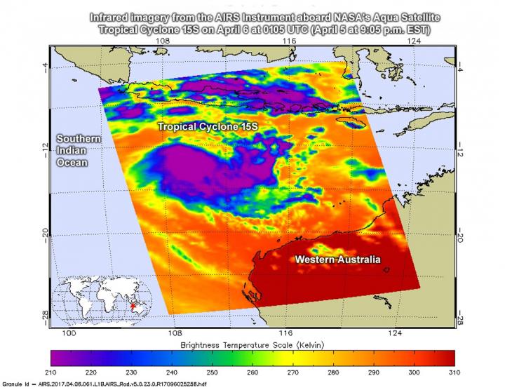
This NASA infrared image of Tropical Cyclone 15S on April 6 at 0105 UTC (April 5 at 9:05 p.m. EST) showed strongest storms with cloud top temperatures of thunderstorms as cold (purple) as -63F/-53C. Credits: NASA JPL, Ed Olsen
The Atmospheric Infrared Sounder or AIRS instrument aboard NASA's Aqua satellite looked at Tropical Cyclone 15S in infrared light. Infrared light provides scientists with temperature data and that's important when trying to understand how strong storms can be. The higher the cloud tops, the colder and the stronger the storms that make up a tropical cyclone.
NASA's Aqua satellite flew over Tropical Cyclone 15S on April 6 at 0605 UTC (2:05 a.m. EST). AIRS detected strongest storms around the center of circulation with cloud top temperatures as cold as minus 63 degrees Fahrenheit (minus 53 degrees Celsius). Storms with cloud top temperatures that cold have the capability to produce heavy rainfall.
The Joint Typhoon Warning Center or JTWC stated on April 6 at 0900 UTC (5 a.m. EST) newly formed Tropical Cyclone 15S had maximum sustained winds near 35 knots (40 mph/62 kph). 15S was centered near 13.5 degrees south latitude and 110.7 degrees east longitude, about 572 nautical miles (658 miles/1,059 km) north-northwest of Learmonth, Australia. 15S was moving to the south-southwest at 4 knots (4.6 mph/7.4 kph) away from Australia.
The JTWC noted “Upper level atmospheric analysis Indicates the system is in an area of strong westerly vertical wind shear. Additionally, a mid-latitude trough or elongated area of low pressure is causing subsidence along the southwestern quadrant (of the storm).”
Subsidence means sinking air, and that prevents cloud formation as air has to rise in order to condense to form clouds and the thunderstorms that make up a tropical cyclone.
Tropical Cyclone 15S is moving along the northwestern edge of an elongated area of subtropical high pressure, which is located southeast of the storm. That means that 15S expected to continue tracking south-southwestward around that high pressure area, turning more to the west as the high pressure builds.
JWTC forecasts this system will be short-lived because vertical wind shear will increase in the direction the storm is heading. It is expected to dissipate in three days by April 9.
Media Contact
All latest news from the category: Earth Sciences
Earth Sciences (also referred to as Geosciences), which deals with basic issues surrounding our planet, plays a vital role in the area of energy and raw materials supply.
Earth Sciences comprises subjects such as geology, geography, geological informatics, paleontology, mineralogy, petrography, crystallography, geophysics, geodesy, glaciology, cartography, photogrammetry, meteorology and seismology, early-warning systems, earthquake research and polar research.


Newest articles

Combatting disruptive ‘noise’ in quantum communication
In a significant milestone for quantum communication technology, an experiment has demonstrated how networks can be leveraged to combat disruptive ‘noise’ in quantum communications. The international effort led by researchers…

Stretchable quantum dot display
Intrinsically stretchable quantum dot-based light-emitting diodes achieved record-breaking performance. A team of South Korean scientists led by Professor KIM Dae-Hyeong of the Center for Nanoparticle Research within the Institute for…

Internet can achieve quantum speed with light saved as sound
Researchers at the University of Copenhagen’s Niels Bohr Institute have developed a new way to create quantum memory: A small drum can store data sent with light in its sonic…

