3 satellites see eruption of Puyehue-Cordón volcano from space
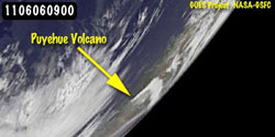
GOES-11 satellite image, taken on June 6 at 0900 UTC (5 a.m. EDT) from the farthest vantage point of any of the satellites, still showed the triangular-shaped plume, even from its position over the western US, despite the large distance. Credit: NASA/NOAA GOES Project, Dennis Chesters<br>
The Terra satellite flew over the volcano on June 6 at 14:25 UTC (10:25 a.m. EDT). The Moderate Resolution Imaging Spectroradiometer (MODIS) instrument captured a visible image of the eruption that showed the large ash plume blowing northeast, then to the southeast and over the Atlantic Ocean. The ash plume went at least as high as six miles on June 4 when it erupted, according to CNN International. Some 3,500 people were evacuated.
The Geostationary Operational Environmental Satellites called GOES-13 and GOES-11 also captured images of the volcano from a different vantage point in space that revealed the plume was visible from even farther away.
GOES-13 monitors the eastern U.S. and the Atlantic Ocean, while GOES-11 monitors the western U.S. and eastern Pacific Ocean. The GOES-11 satellite image, taken from the farthest vantage point of any of the satellites, still showed the triangular-shaped plume, even from its position over the western U.S., despite the large distance.
The GOES satellites are managed by NOAA, and imagery and animations are created with the GOES satellite data at NASA's GOES Project located at NASA's Goddard Space Flight Center, Greenbelt, Md.
Media Contact
More Information:
http://www.nasa.govAll latest news from the category: Earth Sciences
Earth Sciences (also referred to as Geosciences), which deals with basic issues surrounding our planet, plays a vital role in the area of energy and raw materials supply.
Earth Sciences comprises subjects such as geology, geography, geological informatics, paleontology, mineralogy, petrography, crystallography, geophysics, geodesy, glaciology, cartography, photogrammetry, meteorology and seismology, early-warning systems, earthquake research and polar research.


Newest articles

Superradiant atoms could push the boundaries of how precisely time can be measured
Superradiant atoms can help us measure time more precisely than ever. In a new study, researchers from the University of Copenhagen present a new method for measuring the time interval,…

Ion thermoelectric conversion devices for near room temperature
The electrode sheet of the thermoelectric device consists of ionic hydrogel, which is sandwiched between the electrodes to form, and the Prussian blue on the electrode undergoes a redox reaction…

Zap Energy achieves 37-million-degree temperatures in a compact device
New publication reports record electron temperatures for a small-scale, sheared-flow-stabilized Z-pinch fusion device. In the nine decades since humans first produced fusion reactions, only a few fusion technologies have demonstrated…

