GOES-13 on top of new seventeenth Atlantic (sub) tropical depression
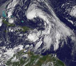
GOES-13 (The Geostationary Operational Environmental Satellite) visible image of Subtropical Depression 17 (top, center) at 1145 UTC (7:45 a.m. EDT) shows a tight circulation and a long \"tail\" of clouds and showers that extend to the southeast of the center, reaching the northern Leeward Islands and Puerto Rico. GOES is operated by NOAA, and the NASA GOES Project at NASA Goddard Space Flight Center, Greenbelt, Md., creates images and animations from the satellite data. Credit: NOAA/NASA GOES Project<br>
A subtropical storm is one where central convection (rapidly rising air that forms thunderstorms) is fairly near the center and it has a warming core in the mid-levels of the troposphere. Subtropical cyclones differ from tropical cyclones because they have broad wind patterns and their maximum sustained winds are located farther from the center of the system than tropical cyclones.
In addition, they usually have colder temperatures in upper levels of the atmosphere than tropical cyclones (which have very warm cores). Finally, sea surface temperatures required for the formation of sub-tropical storms are about 5 degrees Fahrenheit cooler than needed for a tropical cyclone to develop (80 F).
TD17 is forecast by the National Hurricane Center to move into a more favorable environment to develop, and its core may warm up making it into a tropical depression or tropical storm, if it intensifies.
The Geostationary Operational Environmental Satellite called GOES-13 captured an infrared image of TD17 on October 6 at 1231 UTC (8:31 a.m. EDT). GOES satellites are managed by NOAA. NASA's GOES Project at NASA's Goddard Space Flight Center in Greenbelt, Md. creates images and animations from the satellite data and created today's image that shows TD17 has a tight circulation and a long “tail” of clouds and showers that extend to the southeast of the center, reaching the northern Leeward Islands and Puerto Rico.
At 5 a.m. EDT on Oct. 6, TD17's maximum sustained winds were 35 mph. It was located about 270 miles north-northwest of San Juan, Puerto Rico and 710 miles south of Bermuda near 22.2 North and 67.0 West. It was moving northwest at 8 mph with minimum central pressure of 1001 millibars. TD17's “tail” extends to the southeast from the center of the system, and may bring some heavy rainfall in the northern Leeward Islands and Puerto Rico over the next day as it moves northwest then turns northeast to head out to the open waters of the Atlantic.
Media Contact
More Information:
http://www.nasa.govAll latest news from the category: Earth Sciences
Earth Sciences (also referred to as Geosciences), which deals with basic issues surrounding our planet, plays a vital role in the area of energy and raw materials supply.
Earth Sciences comprises subjects such as geology, geography, geological informatics, paleontology, mineralogy, petrography, crystallography, geophysics, geodesy, glaciology, cartography, photogrammetry, meteorology and seismology, early-warning systems, earthquake research and polar research.


Newest articles

Properties of new materials for microchips
… can now be measured well. Reseachers of Delft University of Technology demonstrated measuring performance properties of ultrathin silicon membranes. Making ever smaller and more powerful chips requires new ultrathin…

Floating solar’s potential
… to support sustainable development by addressing climate, water, and energy goals holistically. A new study published this week in Nature Energy raises the potential for floating solar photovoltaics (FPV)…

Skyrmions move at record speeds
… a step towards the computing of the future. An international research team led by scientists from the CNRS1 has discovered that the magnetic nanobubbles2 known as skyrmions can be…

