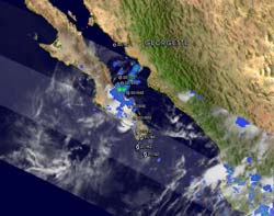
GOES-13's wide view of Atlantic's Tropical Storm Lisa and low, Pacific's Georgette
Georgette was a tropical depression with isolated moderate thunderstorms near the center when the Tropical Rainfall Measuring Mission satellite passed over on Sept. 22 at 0344 UTC. The yellow and green areas indicate moderate rainfall between .78 to 1.57 inches per hour. Credit: NASA/SSAI, Hal Pierce<br>
At 1445 UTC (10:45 a.m. EDT) today, Sept. 22, the Geostationary Operational Environmental Satellite called GOES-13 captured Tropical Storm Lisa in the far eastern Atlantic, a developing tropical low in the south-central Caribbean Sea, and Tropical Storm Georgette in the eastern Pacific Ocean, making landfall in Baja California. The GOES series of satellites are managed by NOAA, and NASA's GOES Project at NASA's Goddard Space Flight Center in Greenbelt, Md. creates images and animations from the satellite data.
Tropical Storm Lisa is struggling today in the eastern Atlantic Ocean because of wind shear and dry air. Lisa was producing a small area of deep convection near the surface of her center of her circulation. The center of circulation is also exposed to outside winds, which make the storm prime for weakening. In addition, there is a lot of dry air around Lisa at the middle levels of the troposphere (likely from the Saharan dust that has been blowing off the African coast). All of those things are indicators why Lisa has not been able to intensify.
The Tropical Rainfall Measuring Mission (TRMM) satellite passed above Lisa on Sept. 21 at 2309 UTC (7:09 p.m. EDT) and revealed a few areas of moderate to heavy thunderstorms with rain falling at about 2 inches per hour within the storm's circulation.
At 11 a.m. EDT on Sept. 22, Lisa had maximum sustained winds near 45 mph. The National Hurricane Center noted that some strengthening is possible over the next 48 hours, so the environmental conditions should become more conducive for the tropical cyclone. Lisa was 435 miles west of the Cape Verde Islands, near 17.1 North and 30.5 West. It was moving very little in a southeasterly direction at 3 mph and is forecast to move little in the next couple of days. Estimated minimum central pressure is 1002 millibars.
Meanwhile, there is a low pressure area in the south-central Caribbean Sea that forecasters are watching. Today's GOES-13 satellite image does show some circulation in the clouds associated with the low. NOAA's National Hurricane Center (NHC) noted that this low has the potential to become the 15th tropical depression of the Atlantic Ocean hurricane season over the next day or two. In fact, NHC gives the low a 60 percent chance of making the grade to tropical depression in 48 hours. That low is expected to bring showers and squalls over the Netherlands Antilles and the northern coasts of western Venezuela and Colombia today.
Further west, Tropical Depression Georgette has already crossed over Baja California and is now headed to another landfall on the mainland in Mexico. A tropical storm watch is in effect for the coast of mainland Mexico from Huatabampito Northward to Bahia Kino.
When the Tropical Rainfall Measuring Mission (TRMM) satellite passed over Georgette on Sept. 22 at 0344 UTC ( Sept. 21 11:44 p.m. EDT) the tropical depression had isolated moderate thunderstorms near the center with rainfall between .78 to 1.57 inches per hour.
Georgette is a tropical depression with maximum sustained winds near 35 mph. It is located in the Sea of Cortes (the Gulf of California) and is about 85 miles south of Guaymas, Mexico. It is centered near 26.8 North and 111.0 West, with a minimum central pressure of 1000 millibars.
The depression is moving toward the north-northwest near 14 mph and is expected to turn north later today making landfall tonight. The NHC noted that “Georgette is expected to produce total rainfall accumulations of 4 to 6 inches over the western portions of the state of Sonora with isolated maximum amounts of 10 inches possible.”
Media Contact
More Information:
http://www.nasa.govAll latest news from the category: Earth Sciences
Earth Sciences (also referred to as Geosciences), which deals with basic issues surrounding our planet, plays a vital role in the area of energy and raw materials supply.
Earth Sciences comprises subjects such as geology, geography, geological informatics, paleontology, mineralogy, petrography, crystallography, geophysics, geodesy, glaciology, cartography, photogrammetry, meteorology and seismology, early-warning systems, earthquake research and polar research.


Newest articles

Skyrmions move at record speeds
… a step towards the computing of the future. An international research team led by scientists from the CNRS1 has discovered that the magnetic nanobubbles2 known as skyrmions can be…
A flexible and efficient DC power converter for sustainable-energy microgrids
A new DC-DC power converter is superior to previous designs and paves the way for more efficient, reliable and sustainable energy storage and conversion solutions. The Kobe University development can…
Technical Trials for Easing the (Cosmological) Tension
A new study sorts through models attempting to solve one of the major challenges of contemporary cosmic science, the measurement of its expansion. Thanks to the dizzying growth of cosmic…

