1 by land and 1 by sea
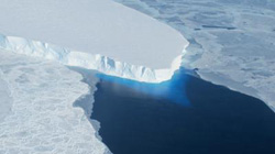
This photo shows the calving front of Thwaites Ice Shelf looking at the ice below the water's surface. Note how the water acts as a blue filter.<br><br>Credit: NASA / Jim Yungel<br>
NASA's Operation IceBridge got the 2012 Antarctic campaign off to a productive start with a land ice survey of Thwaites Glacier and a sea ice flight over parts of the Bellingshausen Sea.
During the first few weeks of a campaign, IceBridge typically concentrates on sea ice before it begins to melt as spring temperatures rise, but as often happens in the field, the weather had other ideas.
On Oct. 12, the IceBridge team met with meteorologists at the Punta Arenas airport to discuss weather conditions and make a final decision on where to fly. “The forecast for all sea ice science targets was hopeless,” said IceBridge project scientist Michael Studinger. “We decided to take advantage of the unusually good conditions over the Thwaites Glacier area.”
Thwaites Glacier is a rapidly-changing ice stream in West Antarctica that flows into Pine Island Bay. A high priority area, Thwaites has been the subject of repeated missions over the past several years by IceBridge and other organizations, such as the Institute for Geophysics at the University of Texas at Austin (UTIG). UTIG is one of IceBridge's partnering organizations, though their survey in this region was part of a project that occurred before IceBridge. Combining new measurements with these previously gathered data gives researchers a more detailed view of parts of Thwaites Glacier, and the resulting information will help with various computer models used to predict how ice sheets change over time.
On Oct. 13, the weather shifted somewhat, allowing for the first sea ice flight of the campaign, a high-priority mission in the Bellingshausen Sea along the west side of the Antarctic Peninsula. This marked the fourth year of data collection over this area. Repeated survey lines on both this flight and the previous one are vital for building a record of change in the Antarctic.
The DC-8 also flew over Burke Island in the Amundsen Sea. Using the DC-8's Coherent Radar Depth Sounder, IceBridge scientists were able to record ice thickness on the small island, something Studinger said is a subject of some interest in the science community.
Media Contact
More Information:
http://www.nasa.govAll latest news from the category: Earth Sciences
Earth Sciences (also referred to as Geosciences), which deals with basic issues surrounding our planet, plays a vital role in the area of energy and raw materials supply.
Earth Sciences comprises subjects such as geology, geography, geological informatics, paleontology, mineralogy, petrography, crystallography, geophysics, geodesy, glaciology, cartography, photogrammetry, meteorology and seismology, early-warning systems, earthquake research and polar research.


Newest articles

“Nanostitches” enable lighter and tougher composite materials
In research that may lead to next-generation airplanes and spacecraft, MIT engineers used carbon nanotubes to prevent cracking in multilayered composites. To save on fuel and reduce aircraft emissions, engineers…

Trash to treasure
Researchers turn metal waste into catalyst for hydrogen. Scientists have found a way to transform metal waste into a highly efficient catalyst to make hydrogen from water, a discovery that…

Real-time detection of infectious disease viruses
… by searching for molecular fingerprinting. A research team consisting of Professor Kyoung-Duck Park and Taeyoung Moon and Huitae Joo, PhD candidates, from the Department of Physics at Pohang University…

