'Groundwater inundation' doubles previous predictions of flooding with future sea level rise
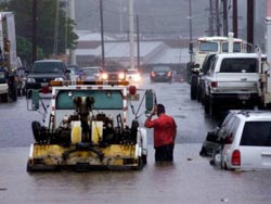
Sea level rise will cause drainage problems in low-lying areas due to groundwater inundation, as seen here in the Mapunapuna area, in Honolulu, Hawaii.<br><br>Credit: D. Oda<br>
Previous research has predicted that by the end of the century, sea level may rise 1 meter. Kolja Rotzoll, Postdoctoral Researcher at the UHM Water Resources Research Center and Charles Fletcher, UHM Associate Dean, found that the flooded area in urban Honolulu, Hawaii, including groundwater inundation, is more than twice the area of marine inundation alone.
Specifically, a 1-meter rise in sea level would inundate 10% of a 1-km wide heavily urbanized area along the shoreline of southern Oahu and 58% of the total flooded area is due to groundwater inundation.
“With groundwater tables near the ground surface, excluding groundwater inundation may underestimate the true threat to coastal communities,” said Rotzoll, lead author of the study.
“This research has implications for communities that are assessing options for adapting to SLR. Adapting to marine inundation may require a very different set of options and alternatives than adapting to groundwater inundation,” states Fletcher, Principle Investigator on the grant that funded the research.
Groundwater inundation is localized coastal-plain flooding due to a simultaneous rise of the groundwater table with sea level. Groundwater inundation is an additional risk faced by coastal communities and environments before marine flooding occurs because the groundwater table in unconfined aquifers typically moves with the ocean surface and lies above mean sea level at some distance from the shoreline.
Rotzoll and Fletcher combined measurements of the coastal groundwater elevation and tidal influence in urban Honolulu with a high-resolution digital elevation model. With this, they were able to assess vulnerability to groundwater inundation from SLR.
“We used the digital elevation model with our improved understanding of groundwater processes to identify areas vulnerable to marine inundation and groundwater inundation,” Rotzoll explained. “It turned out that groundwater inundation poses a significant threat that had not been previously recognized.”
Although effects of SLR on coastal areas have been discussed for a long time, this study is the first to explicitly assess the effects of including groundwater dynamics.
“Finding that the inundated areas double when including groundwater inundation in coastal flooding scenarios will certainly be a surprise for everyone assessing the effects of SLR without considering the local groundwater table,” said Rotzoll. “We hope other coastal communities use our research as the basis for conducting their own localized analysis.”
Strong evidence on climate change underscores the need for actions to reduce the impacts of SLR. Groundwater inundation has consequences for decision-makers, resource managers, and urban planners and may be applicable to many low-lying coastal areas, especially where the groundwater table is near the ground surface and groundwater withdrawal is not substantial. However, groundwater withdrawals can be used to mitigate effects of a rising water table, even if it means pumping brackish water to avoid inundation.
The authors will present the findings from this paper at two international meetings: the Geological Society of America Annual Meeting (Charlotte, NC) and the American Geophysical Union Fall Meeting (San Francisco, CA).
The study's authors plan to substantiate their assessment of the groundwater table with further measurements throughout the coastal Honolulu caprock aquifer and improve understanding of the dynamics of the water table.
Rotzoll, K. and Fletcher, C.H. Assessment of groundwater inundation as a consequence of sea-level rise. Nature Climate Change, DOI: 10.1038/NCLIMATE1725
Media Contact
More Information:
http://www.hawaii.eduAll latest news from the category: Earth Sciences
Earth Sciences (also referred to as Geosciences), which deals with basic issues surrounding our planet, plays a vital role in the area of energy and raw materials supply.
Earth Sciences comprises subjects such as geology, geography, geological informatics, paleontology, mineralogy, petrography, crystallography, geophysics, geodesy, glaciology, cartography, photogrammetry, meteorology and seismology, early-warning systems, earthquake research and polar research.


Newest articles

“Nanostitches” enable lighter and tougher composite materials
In research that may lead to next-generation airplanes and spacecraft, MIT engineers used carbon nanotubes to prevent cracking in multilayered composites. To save on fuel and reduce aircraft emissions, engineers…

Trash to treasure
Researchers turn metal waste into catalyst for hydrogen. Scientists have found a way to transform metal waste into a highly efficient catalyst to make hydrogen from water, a discovery that…

Real-time detection of infectious disease viruses
… by searching for molecular fingerprinting. A research team consisting of Professor Kyoung-Duck Park and Taeyoung Moon and Huitae Joo, PhD candidates, from the Department of Physics at Pohang University…

