Urban planning: City dynamics yield to computer modeling
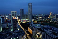
Land use in cities can now be modeled by computer software that allows researchers to predict details such as energy use on individual plots of land. © Brand X Pictures/Thinkstock<br>
The sustainability of cities is a challenge facing planners across the globe. The numerous complex and wide-ranging interactions between energy consumption, water use, transportation and population dynamics make cities intrinsically complicated systems to study.
Christopher Monterola and co-workers at A*STAR’s Institute of High Performance Computing, Singapore, have created a computer modeling system capable of characterizing land-use patterns in different cities1. This software provides planners with the ability to define the features of a particular city, as well as compare and contrast these features with those of other cities.
A city is a complex system, and complex systems evolve as a result of highly interacting units driven by a simple mechanism, Monterola notes. “Understanding the underlying simplicity in the growth of cities will allow us to model the emergence of city dynamics more accurately and, more importantly, learn to shape a city’s growth based on our desired outcomes.”
The team worked with high-resolution image data for Singapore and eight North American cities. They painstakingly categorized land-use into business, residential or industrial sectors, pixel by pixel, for each city. To analyze the dispersion and aggregation of land use types across the urban space, the computer model used two parameters — ‘spatial entropy’, which describes how a given sector is spread across space, and an ‘index of dissimilarity’, which measures the relative mixing of sectors.
“The lower the entropy number, the more densely clustered a given sector is,” explains Monterola. “In the cities studied, industrial areas were generally clustered and distinct from residential and business zones. There is ‘safety in numbers’, but only if the resources required by [a] specific sector are not compromised.”
The index of dissimilarity helped to define the efficiency of different urban factors, especially transportation and energy consumption. In follow-up work, the team successfully modeled the emergence of land use in cities, the surface temperatures for individual plots of land and even accurately estimated ridership — how many people are using public transport at any one time.
“The good visual and statistical resemblance of our simulations to actual cities hints at the robustness of this work so far,” says Monterola. “We will add more details, including schools, churches and so on, with the aim of capturing the day-to-day routines of people in a city.” Monterola believes that this groundwork will yield predictive models of different urban activities resulting from easily measured parameters that will be useful as guides for planners.
The A*STAR-affiliated researchers contributing to this research are from the Institute of High Performance Computing
Media Contact
All latest news from the category: Architecture and Construction


Newest articles

“Nanostitches” enable lighter and tougher composite materials
In research that may lead to next-generation airplanes and spacecraft, MIT engineers used carbon nanotubes to prevent cracking in multilayered composites. To save on fuel and reduce aircraft emissions, engineers…

Trash to treasure
Researchers turn metal waste into catalyst for hydrogen. Scientists have found a way to transform metal waste into a highly efficient catalyst to make hydrogen from water, a discovery that…

Real-time detection of infectious disease viruses
… by searching for molecular fingerprinting. A research team consisting of Professor Kyoung-Duck Park and Taeyoung Moon and Huitae Joo, PhD candidates, from the Department of Physics at Pohang University…

