Weakening post-Tropical Storm Olaf examined by NASA's GPM satellite
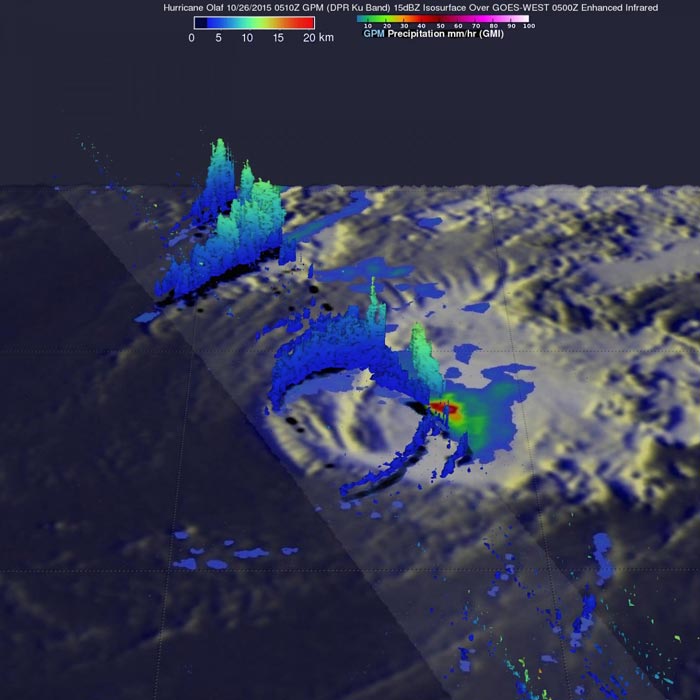
The GPM core satellite found that storms located in a small area within Olaf were still dropping rain at a rate of over 65 mm (2.6 inches) per hour on Oct. 26. Credits: NASA/JAXA/SSAI, Hal Pierce
The Global Precipitation Measurement mission or GPM core satellite is managed by both NASA and the Japan Aerospace Exploration Agency. It flew over Olaf on October 26, 2015 at 0510 UTC (1:10 a.m. EDT).
Rainfall data was derived from GPM's Microwave Imager (GMI) and Dual-Frequency Precipitation Radar (DPR) instruments. Olaf had moved over cooler waters that were sapping the tropical cyclone's energy. GPM's GMI found that storms located in a small area within Olaf were still dropping rain at a rate of over 65 mm (2.6 inches) per hour.
GPM's radar (DPR Ku band) sliced through Olaf's western side and revealed that rainfall was sparse in that area. In a 3-D image created at NASA's Goddard Space Flight Center in Greenbelt, Maryland, the precipitation structure on the storm's western side showed that the highest storm tops were reaching heights of 12 km (7.4 miles). Rain in these storms was measured by DPR falling at a rate of up to 62 mm (2.4 inches) per hour.
By October 27, Olaf had crossed the 140 degree latitude line and moved from the Central Pacific Ocean into the Eastern Pacific Ocean where it become post-tropical.
On Tuesday, October 27, 2015 at 11 a.m. EDT (1500 UTC), the center of Post-Tropical Cyclone Olaf was located near latitude 26.7 degrees north and longitude 135.1 degrees west. It was about 1,355 miles (2,180 km) east-northeast of Hilo, Hawaii.
The post-tropical cyclone was moving toward the east-northeast near 10 mph (17 kph), and the low pressure area is expected to turn toward the southwest and west-southwest on Wednesday, October 28. Maximum sustained winds were near 45 mph (75 kph) with higher gusts. The estimated minimum central pressure was 1000 millibars.
The National Hurricane Center forecast weakening over the next two days and issued its final bulletin on the storm. The post-tropical cyclone is expected to dissipate by Thursday, October 27, 2015.
###
For additional information on the remnant low please see High Seas Forecasts issued by the National Weather Service on the web at http://www.
Media Contact
All latest news from the category: Earth Sciences
Earth Sciences (also referred to as Geosciences), which deals with basic issues surrounding our planet, plays a vital role in the area of energy and raw materials supply.
Earth Sciences comprises subjects such as geology, geography, geological informatics, paleontology, mineralogy, petrography, crystallography, geophysics, geodesy, glaciology, cartography, photogrammetry, meteorology and seismology, early-warning systems, earthquake research and polar research.


Newest articles

Superradiant atoms could push the boundaries of how precisely time can be measured
Superradiant atoms can help us measure time more precisely than ever. In a new study, researchers from the University of Copenhagen present a new method for measuring the time interval,…

Ion thermoelectric conversion devices for near room temperature
The electrode sheet of the thermoelectric device consists of ionic hydrogel, which is sandwiched between the electrodes to form, and the Prussian blue on the electrode undergoes a redox reaction…

Zap Energy achieves 37-million-degree temperatures in a compact device
New publication reports record electron temperatures for a small-scale, sheared-flow-stabilized Z-pinch fusion device. In the nine decades since humans first produced fusion reactions, only a few fusion technologies have demonstrated…

