Watches up in Australia as NASA sees System 99P developing
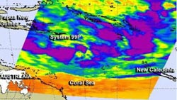
NASA's Aqua satellite passed over System 99P the Southern Pacific Ocean on Jan. 28 at 14:47 UTC/9:47 a.m. EST and saw some strong thunderstorms (high cloud tops) where temperatures exceeded -63F/-52C (purple).<br><br>Credit: NASA JPL, Ed Olsen<br>
Meanwhile, the Australian Bureau of Meteorology posted a Cyclone Watch for coastal areas from Port Douglas to Proserpine, Queensland that are expected to be affected by the storm.
NASA's Aqua satellite passed over System 99P the Southern Pacific Ocean on January 28 at 14:47 UTC/9:47 a.m. EST and saw that some of the thunderstorms had high cloud tops, where temperatures exceeded -63F/-52C. The Atmospheric Infrared Sounder instrument known as AIRS captured infrared data on the low's clouds and revealed that some of the thunderstorms surrounding the low-level center of circulation had the potential for dropping heavy rainfall.
The Joint Typhoon Warning Center noted that animated multi-spectral satellite imagery showed that the low-level center was consolidating and that strong bands of thunderstorms wrapping into the elongated circulation.
System 99P was centered near 15.2 south and 153.4 east in the Coral Sea (Southern Pacific Ocean basin), about 215 nautical miles/247.4 miles/398.2 km east-northeast of Willis Island, Australia. Maximum sustained winds are near the threshold for depression status, currently as high as 30 to 35 knots along the northern and southern edges of the low. The low is located over waters warm enough (28C/86.6F) to support further development.
Forecasters at the Joint Typhoon Warning Center give System 99P a high chance for becoming a tropical depression over the next day as it tracks to the southwest toward Willis Island, Australia. The Australian Bureau of Meteorology or ABM issued a forecast for the low and projected a path to make landfall just north of Townsville, Queensland on January 31. For updates from ABM, please visit: http://www.bom.gov.au/cyclone/index.shtml.
Media Contact
More Information:
http://www.nasa.govAll latest news from the category: Earth Sciences
Earth Sciences (also referred to as Geosciences), which deals with basic issues surrounding our planet, plays a vital role in the area of energy and raw materials supply.
Earth Sciences comprises subjects such as geology, geography, geological informatics, paleontology, mineralogy, petrography, crystallography, geophysics, geodesy, glaciology, cartography, photogrammetry, meteorology and seismology, early-warning systems, earthquake research and polar research.


Newest articles

Silicon Carbide Innovation Alliance to drive industrial-scale semiconductor work
Known for its ability to withstand extreme environments and high voltages, silicon carbide (SiC) is a semiconducting material made up of silicon and carbon atoms arranged into crystals that is…

New SPECT/CT technique shows impressive biomarker identification
…offers increased access for prostate cancer patients. A novel SPECT/CT acquisition method can accurately detect radiopharmaceutical biodistribution in a convenient manner for prostate cancer patients, opening the door for more…

How 3D printers can give robots a soft touch
Soft skin coverings and touch sensors have emerged as a promising feature for robots that are both safer and more intuitive for human interaction, but they are expensive and difficult…

