Volcano breath: Measuring sulfur dioxide from space
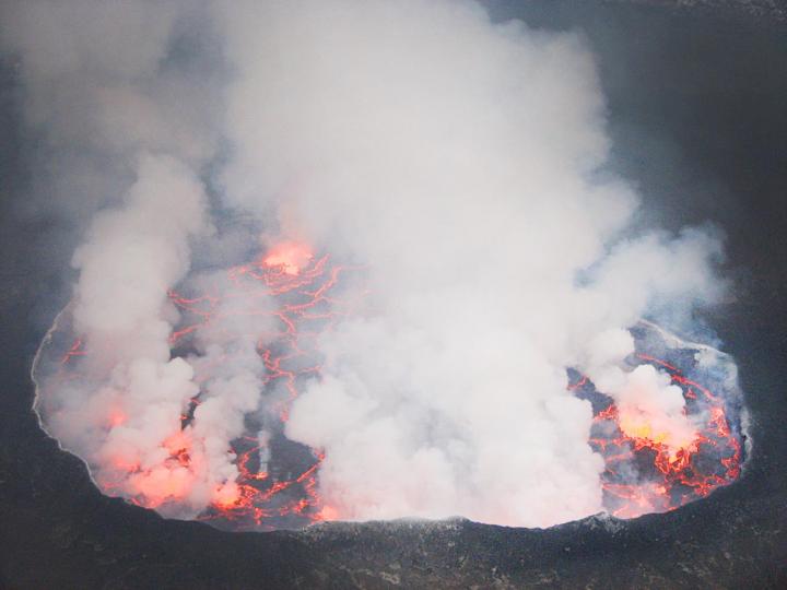
This is a lava lake in the crater of Mount Nyiragongo in the Democratic Republic of the Congo. Credit: Simon Carn/Michigan Technological University
Carn and his team found that each year volcanoes collectively emit 20 to 25 million tons of sulfur dioxide into the atmosphere. While this number is higher than the previous estimate made in the late 1990s based on ground measurements, the new research includes data on more volcanoes, including some that scientists have never visited, and it is still lower than human emissions of sulfur dioxide pollution levels.
Human activities emit about two times as much sulfur dioxide into the atmosphere, according to co-author Vitali Fioletov, an atmospheric scientist at Environment and Climate Change Canada in Toronto, Ontario. He led the effort to catalogue sulfur dioxide emissions sources from human activities and volcanoes and to trace emissions derived from the satellite observations back to their source by using wind data.
Human emissions however are on the decline in many countries due to more strict pollution controls on power plants like burning low-sulfur fuel and technological advances to remove it during and after combustion. As they decrease, the importance of persistent volcanic emissions rises. Volcanoes provide natural background levels of sulfur dioxide that need to be taken into account when studying the global atmosphere and regional effects.
Atmospheric processes convert the gas into sulfate aerosols–small suspended particles in the atmosphere–that reflect sunlight back into space, causing a cooling effect on climate. Sulfate aerosols near the land surface are harmful to breathe. In addition, sulfur dioxide is the primary source of acid rain and is a skin and lung irritant. Health concerns with sulfur dioxide plumes are ongoing in communities on the slopes of persistently degassing volcanoes like Kilauea in Hawaii and Popocatepetl in Mexico.
With daily observations, tracking sulfur dioxide emissions via satellite can also help with eruption forecasting. Along with measuring seismic activity and ground deformation, scientists monitoring satellite data can potentially pick up noticeable increases in gas emissions that may precede eruptions.
“It's complementary to ground-based monitoring,” Carn says, adding that his team says both are needed. “Ground-based measurements of volcanic gases that are more difficult to measure from space, such as carbon dioxide, are crucial. But the satellite data could allow us to target new ground-based measurements at unmonitored volcanoes more effectively, leading to better estimates of volcanic carbon dioxide emissions.”
Ground-based data are more detailed, and in areas like Central America where large sulfur dioxide-emitting volcanoes are close together, they better distinguish which specific volcano gas plumes come from. However, while field measurements of sulfur dioxide emissions are increasing, they still remain too sparse to piece together a cohesive global picture.
That's where this new inventory is handy; it reaches as far as the remote volcanoes of the Aleutian Islands and provides consistent measurements over time from the world's biggest emitters, including Ambrym in Vanuatu and Kilauea in Hawaii.
“Satellites provide us with a unique 'big picture' view of volcanic emissions that is difficult to obtain using other techniques,” Carn says. “We can use this to look at trends in sulfur dioxide emissions on the scale of an entire volcanic arc.”
The work highlights the necessity of consistent long-term data, according to co-author Nick Krotkov, an atmospheric scientist at NASA's Goddard Space Flight Center in Greenbelt, Maryland, which produces the sulfur dioxide data from the Aura satellite. “If you want to look at trends or do other science, the longer time-series is really critical. The value of the data increases with its duration,” he said.
The new volcanic emissions information pulls together opportunities to improve monitoring of natural hazards, human health risks and climate processes–one volcanic breath at a time.
###
Read the paper here.
For more information about past and current satellite sulfur dioxide data, visit NASA's global sulfur dioxide monitoring web site: https:/
To learn about atmospheric composition measurements from visit: https:/
Media Contact
All latest news from the category: Earth Sciences
Earth Sciences (also referred to as Geosciences), which deals with basic issues surrounding our planet, plays a vital role in the area of energy and raw materials supply.
Earth Sciences comprises subjects such as geology, geography, geological informatics, paleontology, mineralogy, petrography, crystallography, geophysics, geodesy, glaciology, cartography, photogrammetry, meteorology and seismology, early-warning systems, earthquake research and polar research.


Newest articles

Skyrmions move at record speeds
… a step towards the computing of the future. An international research team led by scientists from the CNRS1 has discovered that the magnetic nanobubbles2 known as skyrmions can be…
A flexible and efficient DC power converter for sustainable-energy microgrids
A new DC-DC power converter is superior to previous designs and paves the way for more efficient, reliable and sustainable energy storage and conversion solutions. The Kobe University development can…
Technical Trials for Easing the (Cosmological) Tension
A new study sorts through models attempting to solve one of the major challenges of contemporary cosmic science, the measurement of its expansion. Thanks to the dizzying growth of cosmic…

