Tropical Storm Arlene moves inland over Mexico: A GOES-13 satellite movie view
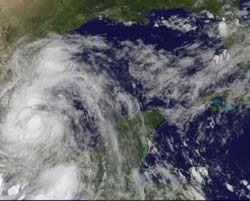
The GOES-13 satellite captured this image of Tropical Storm Arlene at 1431 UTC (10:31 a.m. EDT) on June 30, 2011 as it was inland and just west of Cabo Rojo, Mexico. Credit: Credit: NASA/NOAA GOES Project<br>
Tropical Storm Arlene never made to hurricane strength, but did become a strong tropical storm with maximum sustained winds near 65 mph. To be classified hurricane strength maximum winds need to be 74 mph or greater.
As a strong tropical storm, Arlene is creating a lot of problems with very heavy rainfall causing flash flooding and mudslides in mountainous areas. Arlene is dropping between 4 and 8 inches of rain as it tracks through northern Mexico with isolated amounts up to 15 inches falling in mountainous areas.
Arlene made landfall near Cabo Rojo in northeastern Mexico this morning, June 30 at 7 a.m. EDT. It continues to move west through northern Mexico. By 11 a.m. EDT, Arlene's center was just west of Cabo Rojo as it tracks slowly to the west at 7 mph (11 kmh). It was centered near 21.6 North and 97.7 West. That's about 45 miles north-northwest of Tuxpan and the same distance from Tampico, although south-southeast of that city. Minimum central pressure is 994 millibars.
GOES-13 is one of several satellites keeping track of Tropical Storm Arlene. Because GOES-13 monitors the eastern U.S. and the Atlantic, and Arlene is moving west, the GOES-11 satellite is going to pick up watching Arlene's movements. GOES-11 monitors the western U.S. and the eastern Pacific Ocean.
Both GOES-13 and GOES-11 are operated by NOAA. NASA's GOES Project creates images and animations from both satellites, and used the continuous data from GOES-13 to make a two-day movie showing Arlene's landfall today. NASA's GOES Project works out of the NASA Goddard Space Flight Center in Greenbelt, Md.
The animation shows Arlene from June 28 at 1415 (10:15 a.m. EDT) to June 30 at 1415. In those two days, the circulation of Arlene became more apparent as the center moved away from the Yucatan Peninsula and into the southwestern Gulf of Mexico. Satellite imagery also showed that eastern side of the storm contained more cloud cover when it was over open ocean.
The National Hurricane Center noted that the center of Arlene should continue moving inland over mainland Mexico today and will likely dissipate over the central Mexico mountains sometime on Friday, July 1.
Media Contact
More Information:
http://www.nasa.govAll latest news from the category: Earth Sciences
Earth Sciences (also referred to as Geosciences), which deals with basic issues surrounding our planet, plays a vital role in the area of energy and raw materials supply.
Earth Sciences comprises subjects such as geology, geography, geological informatics, paleontology, mineralogy, petrography, crystallography, geophysics, geodesy, glaciology, cartography, photogrammetry, meteorology and seismology, early-warning systems, earthquake research and polar research.


Newest articles

Properties of new materials for microchips
… can now be measured well. Reseachers of Delft University of Technology demonstrated measuring performance properties of ultrathin silicon membranes. Making ever smaller and more powerful chips requires new ultrathin…

Floating solar’s potential
… to support sustainable development by addressing climate, water, and energy goals holistically. A new study published this week in Nature Energy raises the potential for floating solar photovoltaics (FPV)…

Skyrmions move at record speeds
… a step towards the computing of the future. An international research team led by scientists from the CNRS1 has discovered that the magnetic nanobubbles2 known as skyrmions can be…

