91S Becomes Tropical Cyclone 24S as NASA's TRMM Captures its Rainfall
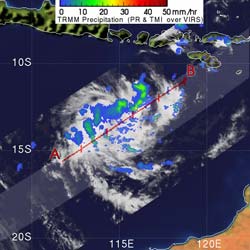
TRMM\'s analysis of rainfall within Tropical Storm 24S on April 22 at 0708 UTC (3:08 a.m. EDT) showed areas of light to moderate rainfall. The yellow and green areas indicate moderate rainfall between .78 to 1.57 inches per hour. Credit: NASA/SSAI, Hal Pierce <br>
TRMM, managed by NASA and the Japanese Space Agency (JAXA) passed over System 91S early today, April 22 at 3:08 Eastern Daylight Time (0708 UTC) and captured a look at the rainfall rates in the storm. TRMM found that there were some areas of light to moderate rainfall between .78 to 1.57 inches per hour.
Rain rates are created from different instruments aboard TRMM. The rain rates in the center of TRMM images are derived from the TRMM Precipitation Radar, the only space borne radar of its kind, while those in the outer portion are from the TRMM Microwave Imager. The rain rates are then overlaid on infrared data from the TRMM Visible Infrared Scanner to create the entire image. The images are created at NASA's Goddard Space Flight Center, in Greenbelt, Md.
At 11 a.m. EDT (1500 UTC) this morning, April 22, Tropical Cyclone 24S had maximum sustained winds near 35 knots (40 mph) making it of tropical storm strength. 24S was about 570 nautical miles north of Learmonth, Australia, near 13.1 South and 115.4 East. It was moving in a southerly direction at 6 mph (5 knots) but it is forecast to turn westward and head into open waters and away from Australia.
Animated infrared satellite imagery shows increased central convection (thunderstorm development) and improved banding of thunderstorms around the center of the cyclone. Because 24S is in an environment of low vertical wind shear, it is expected to further intensify for a couple of days. After that, the wind shear will kick up again and weaken the storm.
Text credit: Rob Gutro, NASA's Goddard Space Flight Center
Media Contact
All latest news from the category: Earth Sciences
Earth Sciences (also referred to as Geosciences), which deals with basic issues surrounding our planet, plays a vital role in the area of energy and raw materials supply.
Earth Sciences comprises subjects such as geology, geography, geological informatics, paleontology, mineralogy, petrography, crystallography, geophysics, geodesy, glaciology, cartography, photogrammetry, meteorology and seismology, early-warning systems, earthquake research and polar research.


Newest articles

Bringing bio-inspired robots to life
Nebraska researcher Eric Markvicka gets NSF CAREER Award to pursue manufacture of novel materials for soft robotics and stretchable electronics. Engineers are increasingly eager to develop robots that mimic the…

Bella moths use poison to attract mates
Scientists are closer to finding out how. Pyrrolizidine alkaloids are as bitter and toxic as they are hard to pronounce. They’re produced by several different types of plants and are…

AI tool creates ‘synthetic’ images of cells
…for enhanced microscopy analysis. Observing individual cells through microscopes can reveal a range of important cell biological phenomena that frequently play a role in human diseases, but the process of…

