Steep rise of the Bernese Alps
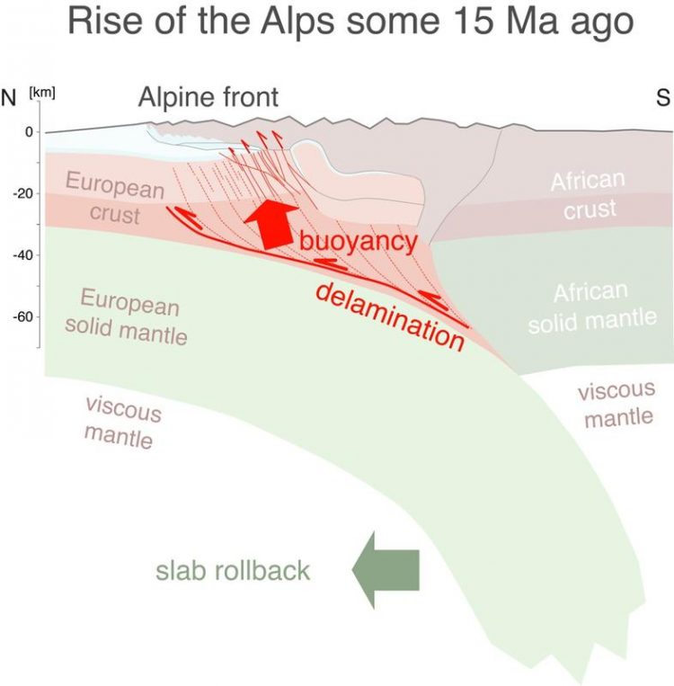
Vertical cross-section through the Alps 15 million years ago. Schematic drawing © M. Herwegh, Institute for Geology, University of Bern.
Mountains often emerge when two tectonic plates converge, where the denser oceanic plate subducts beneath the lighter continental plate into the earth’s mantle according to standard models. But what happens if two continental plates of the same density collide, as was the case in the area of the Central Alps during the collision between Africa and Europe?
Geologists and geophysicists at the University of Bern and ETH Zürich examined this question. They constructed the 3D geometry of deformation structures through several years of surface analysis in the Bernese Alps. With the help of seismic tomography, similar to ultrasound examinations on people, they also gained additional insight into the deep structure of the earth’s crust and beyond down to depths of 400 km in the earth’s mantle.
Viscous rocks from the depths
A reconstruction based on this data indicated that the European crust’s light, crystalline rocks cannot be subducted to very deep depths but are detached from the earth’s mantle in the lower earth’s crust and are consequently forced back up to the earth’s surface by buoyancy forces.
Steep fault zones are formed here, which push through the earth’s crust and facilitate the steep rise of rocks from the depths. There are textbook examples of these kinds of fault zones in the Hasli valley, where they appear as scars in form of morphological incisions impressively cutting through the glacially polished granite landscape.
The detachment of the earth’s crust and mantle takes place at a depth of 25-30 kilometres. This process is triggered by the slow sinking and receding of the European plate in the upper earth’s mantle towards the north. In specialist terminology, this process is called slab rollback. The high temperatures at these depths make the lower crust’s rocks viscous, where they can subsequently be forced up by buoyant uplift forces.
Together with surface erosion, it is this steep rise of the rocks from lower to mid-crustal levels which is responsible for the Bernese Alps’ steep north front today (Titlis – Jungfrau region – Blüemlisalp range). The uplift data in the range of one millimetre per year and today’s earthquake activity indicate that the process of uplift from the depths is still in progress. However, erosion on the earth’s surface causes continuous ablation which is why the Alps do not carry on growing upwards endlessly.
Important for natural hazards and geothermal energy
The analysis of the steep fault zones are not just of scientific interest though. The seismic partly still active faults are responsible for the rocks weathering more intensively on the surface and therefore landslides and debris flows occurring, for example in the Halsi valley in the extremely steep areas of the Spreitlaui or Rotlaui. The serious debris flows in the Guttannen area are based, among other things, on this structural preconditioning of the host rocks.
The leakage of warm hydrothermal water, which it is important to explore for geothermal energy and the 2050 energy policy, can be traced directly back to the brittle fracturing of the upper earth’s crust and the seeping in of cold surface waters. The water is heated up in the depths and arrives at the surface again through the steep fault zones – for example, in the Grimsel region. In this sense, the new findings lead to a deeper understanding of surface processes, which influence our infrastructures, for example the transit axes (rail, roads) through the Alps.
Publication details:
Marco Herwegh, Alfons Berger, Roland Baumberger, Philip Wehrens & Edi Kissling: «Large-Scale Crustal-Block-Extrusion During Late Alpine Collision», Scientific Reports, 24.03.2017, doi: 10.1038/s41598-017-00440-0
Contact:
Prof. Marco Herwegh, Institute of Geological Sciences, University of Bern
Tel. +41 31 631 87 61 / 87 64 / marco.herwegh@geo.unibe.ch
Prof. Edi Kissling, Institute for Geophysics at ETH Zürich
Tel. +41 44 633 26 23 / kiss@tomo.ig.erdw.ethz.ch
http://www.unibe.ch/aktuell/medien/media_relations/medienmitteilungen/2017/index…
Media Contact
All latest news from the category: Earth Sciences
Earth Sciences (also referred to as Geosciences), which deals with basic issues surrounding our planet, plays a vital role in the area of energy and raw materials supply.
Earth Sciences comprises subjects such as geology, geography, geological informatics, paleontology, mineralogy, petrography, crystallography, geophysics, geodesy, glaciology, cartography, photogrammetry, meteorology and seismology, early-warning systems, earthquake research and polar research.


Newest articles

Superradiant atoms could push the boundaries of how precisely time can be measured
Superradiant atoms can help us measure time more precisely than ever. In a new study, researchers from the University of Copenhagen present a new method for measuring the time interval,…

Ion thermoelectric conversion devices for near room temperature
The electrode sheet of the thermoelectric device consists of ionic hydrogel, which is sandwiched between the electrodes to form, and the Prussian blue on the electrode undergoes a redox reaction…

Zap Energy achieves 37-million-degree temperatures in a compact device
New publication reports record electron temperatures for a small-scale, sheared-flow-stabilized Z-pinch fusion device. In the nine decades since humans first produced fusion reactions, only a few fusion technologies have demonstrated…

