Purdue scientist adds third dimension to earth beneath our feet
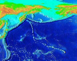
Under the boundary between two crustal plates, zones in the mantle with different temperatures swirl together like storm fronts in the atmosphere. Over the millennia, these subterranean warm and cold fronts produce storms in the mantle that can move mountains up on the crust. (Image provided by Scott D. King) <br>
The swirl of malleable rock in the earth’s mantle – located between the earth’s crust and core – may have greater effect on the earth’s surface than was once believed, a Purdue research team reports.
Using computer technology to create three-dimensional models of the earth’s mantle, Purdue’s Scott King has found evidence that some dramatic features of the earth’s surface could be the result of relatively rapid shifts in the direction in which crustal plates move. Rather than simply drifting along in straight lines over millions of years, plates can be pushed aside or even be made to reverse direction due to convection in the mantle far beneath them.
“This is not an idea that has been seriously considered before,” said King, professor of earth and atmospheric sciences. “Up until this point, plates were thought to change direction more or less independently from the slow-moving mantle. But with the aid of better computer technology, now we are beginning to realize that they are interconnected. The third dimension is important – we have to consider the earth’s depths if we are ever to understand its surface.”
The research, which will appear in the Oct. 15 print issue of Earth and Planetary Science Letters, could spur a rethinking of how major geological features, such as continents and mountain ranges, change shape over time.
Past theories considered crustal plates to be essentially flat objects that either broke into smaller pieces or slid under one another when they collided. The remote depths of the earth’s mantle were thought to have little effect on plate motion because of their own comparatively slow movement.
“The crustal plates themselves move very slowly – only a few inches a year,” King said. “But the depths of the mantle were believed to move even more slowly than that. The accepted theory was that all the fast action was taking place near the surface, so the earth’s depths could be safely neglected when considering changes in plate motion.”
But King and his colleagues were suspicious of some of the earth’s surface features, such as the Hawaii-Emperor seamount chain. This long string of undersea mountains formed one by one as the crust moved across a hot spot in the mantle, which over millions of years left a string of volcanoes on the Pacific’s floor. The chain of seamounts – some of which pierce the surface to form the Hawaiian Islands – takes a sharp turn from the northwest to the north around Midway Island, then stretches nearly as far as the Aleutians. While scientists had known about the bend in the seamount chain for years, no one had found a testable explanation for its existence.
“If the crust was just drifting along in the same direction, a mountain range would not have grown with such a sharp angle in it,” King said. “We started to think that the crust was originally drifting northward, but that some other force must have changed its direction halfway along the line. However, until recently, it was difficult to peer deep enough into the earth to find that force.”
A new perspective became possible when King and his colleagues gained access to powerful computer systems at Los Alamos National Laboratory and Purdue. These computers were able to crunch the huge quantities of data necessary to model the earth’s interior in three dimensions.
“The computers are like a window into the mantle,” King said. “For the first time, we had tools that could translate a complicated set of equations about the mantle into visual maps the human eye can read.”
Much as a CAT scan shows slices of the body, the 3-D maps King’s group produced show different slices of the planet. The cooler and warmer regions of the mantle, which are in constant flux hundreds of miles below our feet, twist around each other like gathering storm clouds. Over the millennia, these subterranean warm and cold fronts produce storms in the mantle that can move mountains up on the crust.
“In a sense, we’re trying to figure out the weather of the earth’s mantle,” King said. “The ’storms’ take eons to manifest themselves, but over time they exert powerful force on crustal plates – enough, for example, to make a large part of the Pacific Ocean floor change its direction by about 45 degrees. That’s what we think we are seeing in the Hawaii-Emperor seamount chain.”
King is optimistic that the group’s work will shed light on the movement of the earth’s crustal plates, but emphasizes that their theory – like others before it – is not yet the complete picture.
“One of the criticisms that our colleagues have made is that we concentrate on the third dimension, depth, at the expense of surface effects,” King said. “Our computer model considers crustal plates as having a constant surface area. But we know that they can grow, crumble and shrink over time. We are working to include these factors in our computer models to improve our knowledge of the ground we walk on even further.”
This research was a collaboration between King, Carl W. Gable of Los Alamos National Laboratory, and Julian Lowman of Leeds University. Funding was provided by the National Science Foundation, Los Alamos National Laboratory Institute of Geophysics and Planetary Physics, and Purdue.
Writer: Chad Boutin, (765) 494-2081, cboutin@purdue.edu
Sources: Scott D. King, (765) 494-3696, sking@purdue.edu
Carl W. Gable, (505) 665-3533, gable@lanl.gov
Julian Lowman, (113) 343-5212, j.lowman@earth.leeds.ac.uk
Media Contact
All latest news from the category: Earth Sciences
Earth Sciences (also referred to as Geosciences), which deals with basic issues surrounding our planet, plays a vital role in the area of energy and raw materials supply.
Earth Sciences comprises subjects such as geology, geography, geological informatics, paleontology, mineralogy, petrography, crystallography, geophysics, geodesy, glaciology, cartography, photogrammetry, meteorology and seismology, early-warning systems, earthquake research and polar research.


Newest articles

Bringing bio-inspired robots to life
Nebraska researcher Eric Markvicka gets NSF CAREER Award to pursue manufacture of novel materials for soft robotics and stretchable electronics. Engineers are increasingly eager to develop robots that mimic the…

Bella moths use poison to attract mates
Scientists are closer to finding out how. Pyrrolizidine alkaloids are as bitter and toxic as they are hard to pronounce. They’re produced by several different types of plants and are…

AI tool creates ‘synthetic’ images of cells
…for enhanced microscopy analysis. Observing individual cells through microscopes can reveal a range of important cell biological phenomena that frequently play a role in human diseases, but the process of…

