NASA spots Tropical Storm Jangmi moving into Sulu Sea
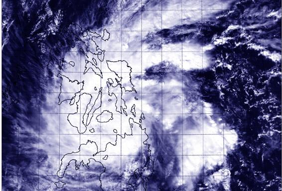
NASA's Aqua satellite captured this image of Tropical Storm Jangmi over the central and southern Philippines on Dec. 29 at 5:05 UTC. Image Credit: NASA/NRL
Many warnings remain in effect as Jangmi continues moving west toward the South China Sea. On Dec. 29, public storm warning signal #1 is in effect in the Visayas provinces of Leyte, Southern Leyte, Camotes Island, rest of Cebu, rest of Negros Occidental, Guimaras, southern part of Iloilo and southern part of Antique. The public storm warning #1 is also in effect in the Mindanao provinces of Bukidnon, Lanao del Norte and Sur, Misamis Occidental Zamboanga del Norte and Sur and Sibugay, Agusan del Sur.
The public storm warning signal #2 is in effect in the Visayas provinces of Bohol, Siquijor, Southern Cebu, Negros Oriental, Southern part of Negros Occidental. It is also in effect in the Mindanao provinces of Surigao del Norte, Siargao Island, Agusan del Norte, Misamis Oriental, Camiguin, and the Dinagat Province.
Tropical Storm Jangmi made landfall in northeastern Mindanao, Philippines on Dec. 28 and has moved across the central part of the country. NASA's Aqua satellite passed over Jangmi on Dec. 29 at 05:05 UTC (12:05 a.m. EST) and saw that the storm was over the Visayas (central) and Mindanao (southern) regions of the country. Bands of thunderstorms wrapped into the center from the northeastern and southeastern quadrants stretching back over the Philippine Sea (east of the country).
On Dec. 29 at 1500 UTC (10 a.m. EST), Jangmi had maximum sustained winds near 40 knots. It was moving to the northwest at 9 knots. Jangmi was centered near 10.0 north latitude and 124.2 east longitude, about 352 nautical miles southeast of Manila.
The Joint Typhoon Warning Center (JTWC) looked at animated enhanced infrared satellite imagery and a radar animation from Cebu Station, Philippines that showed Jangmi intensified as it tracked across the Surigao Strait. The low level circulation had become more tightly wrapped and better defined despite a weakening in the bands of thunderstorms as the system made landfall across Bohol Island.
JTWC's forecast on Dec. 29 calls for Jangmi to move in a west-southwesterly direction through the Sulu Sea and over southern Palawan before moving into the South China Sea while maintaining strength as a tropical storm. The current JTWC forecast track takes Jangmi toward the border of southern Thailand and northern Malaysia around January 3, 2015.
Rob Gutro
NASA's Goddard Space Flight Center
Media Contact
All latest news from the category: Earth Sciences
Earth Sciences (also referred to as Geosciences), which deals with basic issues surrounding our planet, plays a vital role in the area of energy and raw materials supply.
Earth Sciences comprises subjects such as geology, geography, geological informatics, paleontology, mineralogy, petrography, crystallography, geophysics, geodesy, glaciology, cartography, photogrammetry, meteorology and seismology, early-warning systems, earthquake research and polar research.


Newest articles

Silicon Carbide Innovation Alliance to drive industrial-scale semiconductor work
Known for its ability to withstand extreme environments and high voltages, silicon carbide (SiC) is a semiconducting material made up of silicon and carbon atoms arranged into crystals that is…

New SPECT/CT technique shows impressive biomarker identification
…offers increased access for prostate cancer patients. A novel SPECT/CT acquisition method can accurately detect radiopharmaceutical biodistribution in a convenient manner for prostate cancer patients, opening the door for more…

How 3D printers can give robots a soft touch
Soft skin coverings and touch sensors have emerged as a promising feature for robots that are both safer and more intuitive for human interaction, but they are expensive and difficult…

