NASA Sees Newborn Twenty-ninth Depression in the Philippine Sea
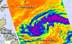
The AIRS instrument aboard NASA's Aqua satellite captured infrared data on Tropical Depression 29W on Oct. 29 at 04:23 UTC/12:23 a.m. EDT and saw strong thunderstorms (purple) west and east of the center. <br>Image Credit: NASA JPL, Ed Olsen<br>
The Philippine Sea is located within the northwestern Pacific Ocean. It's located east and north of the Philippines and covers about 2 million square miles (5 million square kilometers).
The Atmospheric Infrared Sounder or AIRS instrument aboard NASA's Aqua satellite captured infrared data on Tropical Depression 29W on Oct. 29 at 04:23 UTC/12:23 a.m. EDT. AIRS data revealed strong thunderstorms with cloud top temperatures exceeding -63F/-52C that indicated they were high in the troposphere. They thunderstorms appeared in bands west and east of the center. Those thunderstorms were part of bands that formed around the circulation center.
On Oct. 29 at 11 a.m. EDT/1500 UTC, Tropical Depression 29W had maximum sustained winds near 30 knots/34.5 mph/55.5 kph. It was located near 15.7 north and 131.3 east, about 634 nautical miles/729.6 miles/1,174 km east of Manila, Philippines. 29W is moving to the west at 14 knots/16.1 mph/21.3 kph and is expected to continue moving in that general direction over the next couple of days.
Forecasters at the Joint Typhoon Warning Center noted that warm sea surface temperatures in the Philippine Sea (where it is currently moving through) will enable 29W to strengthen into a typhoon in the next one or two days.
29W is expected to move west crossing over Luzon (the northern Philippines) as a tropical storm sometime on Oct. 31 then move into the South China Sea.
Text credit: Rob Gutro
NASA's Goddard Space Flight Center
Media Contact
All latest news from the category: Earth Sciences
Earth Sciences (also referred to as Geosciences), which deals with basic issues surrounding our planet, plays a vital role in the area of energy and raw materials supply.
Earth Sciences comprises subjects such as geology, geography, geological informatics, paleontology, mineralogy, petrography, crystallography, geophysics, geodesy, glaciology, cartography, photogrammetry, meteorology and seismology, early-warning systems, earthquake research and polar research.


Newest articles

Bringing bio-inspired robots to life
Nebraska researcher Eric Markvicka gets NSF CAREER Award to pursue manufacture of novel materials for soft robotics and stretchable electronics. Engineers are increasingly eager to develop robots that mimic the…

Bella moths use poison to attract mates
Scientists are closer to finding out how. Pyrrolizidine alkaloids are as bitter and toxic as they are hard to pronounce. They’re produced by several different types of plants and are…

AI tool creates ‘synthetic’ images of cells
…for enhanced microscopy analysis. Observing individual cells through microscopes can reveal a range of important cell biological phenomena that frequently play a role in human diseases, but the process of…

