NASA sees heavy rain in Tropical Cyclone Emeraude
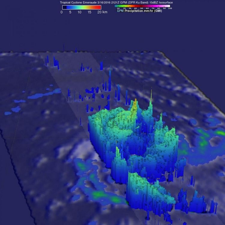
On March 16 GPM measured rainfall just northwest of Emeraude's eye falling at a rate of over 209 mm (8.2 inches) per hour. The powerful thunderstorms that were creating that heavy rain reached altitudes above 15.7 km (9.7 miles). Credits: NASA/JAXA/SSAI, Hal Pierce
Tropical Cyclone Emeraude formed on March 15, 2016 from a tropical low pressure area and intensified rapidly. By March 16 it was a tropical storm and a hurricane on March 17.
The GPM core observatory satellite flew above intensifying Emeraude on March 16, 2016 at 2121Z 5:21 p.m. EDT) after the tropical cyclone's maximum sustained winds had increased to greater than 90 knots (103.5 mph). At that time GPM's Dual-Frequency Precipitation Radar (DPR) instrument measured rainfall just northwest of Emeraude's eye falling at a rate of over 209 mm (8.2 inches) per hour. The powerful thunderstorms producing this extreme rainfall were measured by GPM's radar (DPR) reaching an altitude above 15.7 km (9.7 miles).
Emeraude continued to intensify after GPM passed overhead, with maximum sustained winds peaking on March 17 at 0900 UTC (5 a.m. EST) at 125 knots. Emeraude then started a weakening trend.
By March 18 at 0900 UTC (5 a.m. EDT), Tropical Cyclone Emeraude's maximum sustained winds had dropped to 85 knots (97.8 mph/157.4 kph). It was centered near 10.1 degrees south latitude and 84.5 degrees east longitude, about 734 nautical miles (844.7 miles/1,359 km) east-southeast of Diego Garcia and far from any land areas. Emeraude was moving to the east at 3 knots (3.4 mph/5.5 kph).
Emeraude is expected to re-intensify as it curves toward the southwest continuing over open waters of the Southern Indian Ocean.
Media Contact
All latest news from the category: Earth Sciences
Earth Sciences (also referred to as Geosciences), which deals with basic issues surrounding our planet, plays a vital role in the area of energy and raw materials supply.
Earth Sciences comprises subjects such as geology, geography, geological informatics, paleontology, mineralogy, petrography, crystallography, geophysics, geodesy, glaciology, cartography, photogrammetry, meteorology and seismology, early-warning systems, earthquake research and polar research.


Newest articles

Silicon Carbide Innovation Alliance to drive industrial-scale semiconductor work
Known for its ability to withstand extreme environments and high voltages, silicon carbide (SiC) is a semiconducting material made up of silicon and carbon atoms arranged into crystals that is…

New SPECT/CT technique shows impressive biomarker identification
…offers increased access for prostate cancer patients. A novel SPECT/CT acquisition method can accurately detect radiopharmaceutical biodistribution in a convenient manner for prostate cancer patients, opening the door for more…

How 3D printers can give robots a soft touch
Soft skin coverings and touch sensors have emerged as a promising feature for robots that are both safer and more intuitive for human interaction, but they are expensive and difficult…

