NASA Sees a Weaker Tropical Storm Julio Far North of Hawaii
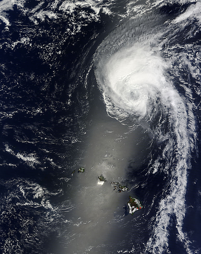
NASA's Terra satellite captured this visible image of Tropical Storm Julio far north of Hawaii on August 11 at 21:25 UTC. Image Credit: NASA Goddard MODIS Rapid Response Team
NASA's Terra satellite passed over Julio and saw that the bulk of the clouds and precipitation were being pushed to the34 north of the center as the storm tracked far north of the Hawaiian Islands.
NASA's Terra satellite passed over Julio on August 11 at 21:25 UTC (5:25 p.m. EDT) and the Moderate Resolution Imaging Spectroradiometer or MODIS instrument aboard took a visible picture of the storm.
The MODIS image revealed a circular center, but most of the clouds and showers associated with the storm were pushed north of the center. Drier air, located over the southern quadrant of the storm is sapping the development of thunderstorms.
Julio tracked far enough away from the Hawaiian Islands so that no watches or warnings were generated for the storm.
At 5 a.m. HST local time (1500 UTC/11 a.m. EDT) on August 12, the center of Tropical Storm Julio was located near latitude 28.6 north, longitude 157.1 west, about 505 miles (815 km) north of Honolulu Hawaii.
Julio was moving toward the northwest near 6 mph (9 kph) and NOAA's Central Pacific Hurricane Center (CPHC) expects that motion to continue over the next day before the storm gradually turns north.
Maximum sustained winds were near 65 mph (100 kph) and a slow weakening is forecast over the next two days.
The CPHC expects that cooler waters and increasing wind shear will weaken Julio into a depression by August 14.
Text credit: Rob Gutro
NASA's Goddard Space Flight Center
Media Contact
All latest news from the category: Earth Sciences
Earth Sciences (also referred to as Geosciences), which deals with basic issues surrounding our planet, plays a vital role in the area of energy and raw materials supply.
Earth Sciences comprises subjects such as geology, geography, geological informatics, paleontology, mineralogy, petrography, crystallography, geophysics, geodesy, glaciology, cartography, photogrammetry, meteorology and seismology, early-warning systems, earthquake research and polar research.


Newest articles

Superradiant atoms could push the boundaries of how precisely time can be measured
Superradiant atoms can help us measure time more precisely than ever. In a new study, researchers from the University of Copenhagen present a new method for measuring the time interval,…

Ion thermoelectric conversion devices for near room temperature
The electrode sheet of the thermoelectric device consists of ionic hydrogel, which is sandwiched between the electrodes to form, and the Prussian blue on the electrode undergoes a redox reaction…

Zap Energy achieves 37-million-degree temperatures in a compact device
New publication reports record electron temperatures for a small-scale, sheared-flow-stabilized Z-pinch fusion device. In the nine decades since humans first produced fusion reactions, only a few fusion technologies have demonstrated…

