NASA paints a panorama of Pacific tropical cyclones
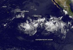
NOAA's GOES-15 satellite captured and image of Hurricane Henriette and two trailing and developing low pressure areas in the Eastern Pacific ocean on Aug. 9 at 1200 UTC (8 a.m. EDT).<br><br>Credit: NASA GOES Project<br>
An image from NOAA's GOES-West satellite on Aug. 9 at 1200 UTC (8 a.m. EDT) captured all three tropical systems. The storm farthest west is Hurricane Henriette, followed by System 92E to the east.
System 92E is trailed by System 93E even further east. The GOES-West imagery shows that System 92E has a more developed circulation, and the National Hurricane Center gives that low pressure area a much higher chance to develop in the next couple of days than System 93E.The GOES-West image was created at NASA's GOES Project at NASA's Goddard Space Flight Center in Greenbelt, Md.
Henriette Losing its Punch
On Aug. 9 at 1500 UTC (11 a.m. EDT), Hurricane Henriette has been weakening and maximum sustained winds have dropped to 75 mph/120 kph. Henriette was centered near 16.4 north and 141.4 west, about 930 miles/1,495 km east-southeast of Hilo, Hawaii. Henriette was moving to the west-southwest at 14 mph/22 kph and had a minimum central pressure of 992 millibars.
GOES-West imagery showed that Henriette has become more asymmetric, a sign of weakening. Tropical cyclones need to be circular in shape to maintain strength or strengthen. When they begin losing the circular shape, they start to “spin down” and slow down like a tire going flat. Infrared satellite data showed that the thunderstorm cloud top temperatures on the southern side of the storm were warming, indicating cloud heights were dropping. Warmer cloud top temperatures indicate lower storms, which means that they don't have as much uplift or strength in them as they did before.
The Central Pacific Hurricane Center noted that Henriette is expected to weaken to tropical storm force later on Aug. 9 and dissipate by Monday, Aug. 12.
System 93E a Slow-Developing Storm
System 93E is not developing as fast as its “sister” low pressure area, System 92E that trails to the east. GOES-West satellite imagery shows that this elongated area of low pressure (trough) is producing disorganized showers and thunderstorms. It is centered about 1,600 miles southwest of the southern tip of Baja California, Mexico. The National Hurricane Center noted that conditions are expected to be marginally conducive for gradual development of this system during the next few days, so the system has a low chance, about 20 percent, of becoming a tropical cyclone during the next two days.
System 92E on a Faster Tropical Track
System 92E is unlike its sister, 93E, and appears to be developing faster. Showers and thunderstorms associated with low pressure System 92E appear much more organized on the GOES-West satellite data. The low is centered about 800 miles southwest of Manzanillo, Mexico, near 10.6 north and 111.4 west. It is moving to the west at 10 to 15 mph. The National Hurricane Center gives System 92E a medium chance, about 50 percent, of becoming a tropical cyclone during the next two days.
Media Contact
More Information:
http://www.nasa.govAll latest news from the category: Earth Sciences
Earth Sciences (also referred to as Geosciences), which deals with basic issues surrounding our planet, plays a vital role in the area of energy and raw materials supply.
Earth Sciences comprises subjects such as geology, geography, geological informatics, paleontology, mineralogy, petrography, crystallography, geophysics, geodesy, glaciology, cartography, photogrammetry, meteorology and seismology, early-warning systems, earthquake research and polar research.


Newest articles

Silicon Carbide Innovation Alliance to drive industrial-scale semiconductor work
Known for its ability to withstand extreme environments and high voltages, silicon carbide (SiC) is a semiconducting material made up of silicon and carbon atoms arranged into crystals that is…

New SPECT/CT technique shows impressive biomarker identification
…offers increased access for prostate cancer patients. A novel SPECT/CT acquisition method can accurately detect radiopharmaceutical biodistribution in a convenient manner for prostate cancer patients, opening the door for more…

How 3D printers can give robots a soft touch
Soft skin coverings and touch sensors have emerged as a promising feature for robots that are both safer and more intuitive for human interaction, but they are expensive and difficult…

